Climate of Little Rock, Arkansas
Little Rock has a humid subtropical climate (Köppen Cfa), with hot, usually humid summers, but subject to drought, primarily in late summer. According to the Trewartha climate classification system, Little Rock is subtropical because nine of its months exceed 50 °F (10 °C) in average temperature. Summers are usually hot, occasionally extremely hot; winters are short and cool, but with marked temperature variations, as the area is subject to alternating incursions of warm, moist air from the Gulf of Mexico (possibly producing daily high temperatures in the 70s F.) and cold, dry air from Canada (possibly producing daily high temperatures below freezing, 32 F., even in the 20s F.). The Little Rock area has nearly 50 inches of precipitation per year, on average. Little Rock experiences a prolonged spring wet season, with heavy rainfall a distinct possibility from March to May, and a secondary wet season peaking in November and December. On average, August is the driest month, and July through September is the driest period of the year. Little Rock averages more rain than the national average, but also averages more sunny days than the national average. Thunderstorms can occur any month of the year, but are especially frequent and severe in spring, when torrential rainfall, damaging thunderstorm winds, hail, and tornadoes are all significant threats; a secondary severe weather season peaks in November. Snow, sleet and freezing rain are rare, but can occur during the winter season, when cold Canadian air at ground level is overrun by warm, moist air from the Gulf of Mexico. Unless otherwise indicated, all normal data presented below are based on data at Bill and Hillary Clinton National Airport the official Little Rock climatology station, from the 1981−2010 normals period.
General climatology
Temperature
| Climate data for Little Rock (Little Rock Nat'l Airport), 1981−2010 normals,[lower-alpha 1] extremes 1875−present[lower-alpha 2] | |||||||||||||
|---|---|---|---|---|---|---|---|---|---|---|---|---|---|
| Month | Jan | Feb | Mar | Apr | May | Jun | Jul | Aug | Sep | Oct | Nov | Dec | Year |
| Record high °F (°C) | 83 (28) |
87 (31) |
91 (33) |
95 (35) |
98 (37) |
107 (42) |
112 (44) |
114 (46) |
106 (41) |
98 (37) |
86 (30) |
81 (27) |
114 (46) |
| Mean maximum °F (°C) | 71.6 (22.0) |
75.9 (24.4) |
81.6 (27.6) |
86.4 (30.2) |
91.3 (32.9) |
96.2 (35.7) |
100.3 (37.9) |
100.9 (38.3) |
96.1 (35.6) |
88.5 (31.4) |
80.0 (26.7) |
71.9 (22.2) |
102.6 (39.2) |
| Average high °F (°C) | 50.5 (10.3) |
55.1 (12.8) |
64.0 (17.8) |
73.1 (22.8) |
81.1 (27.3) |
88.9 (31.6) |
92.5 (33.6) |
92.6 (33.7) |
85.6 (29.8) |
74.8 (23.8) |
63.0 (17.2) |
52.3 (11.3) |
72.9 (22.7) |
| Average low °F (°C) | 31.2 (−0.4) |
34.5 (1.4) |
42.7 (5.9) |
51.0 (10.6) |
61.1 (16.2) |
69.4 (20.8) |
73.2 (22.9) |
72.4 (22.4) |
64.5 (18.1) |
52.6 (11.4) |
42.2 (5.7) |
33.7 (0.9) |
52.5 (11.4) |
| Mean minimum °F (°C) | 15.5 (−9.2) |
19.3 (−7.1) |
26.7 (−2.9) |
35.8 (2.1) |
47.0 (8.3) |
58.0 (14.4) |
64.8 (18.2) |
62.9 (17.2) |
48.2 (9.0) |
36.8 (2.7) |
26.5 (−3.1) |
18.2 (−7.7) |
11.3 (−11.5) |
| Record low °F (°C) | −8 (−22) |
−12 (−24) |
11 (−12) |
28 (−2) |
38 (3) |
46 (8) |
54 (12) |
52 (11) |
37 (3) |
27 (−3) |
10 (−12) |
−1 (−18) |
−12 (−24) |
| Average precipitation inches (mm) | 3.55 (90) |
3.66 (93) |
4.68 (119) |
5.14 (131) |
4.87 (124) |
3.65 (93) |
3.27 (83) |
2.59 (66) |
3.18 (81) |
4.91 (125) |
5.28 (134) |
4.97 (126) |
49.75 (1,264) |
| Average snowfall inches (cm) | 1.6 (4.1) |
1.3 (3.3) |
0.4 (1.0) |
0 (0) |
0 (0) |
0 (0) |
0 (0) |
0 (0) |
0 (0) |
0 (0) |
trace | 0.2 (0.51) |
3.5 (8.9) |
| Average precipitation days (≥ 0.01 in) | 8.9 | 9.1 | 9.8 | 9.4 | 11.1 | 8.7 | 8.2 | 6.4 | 7.3 | 8.2 | 8.9 | 9.7 | 105.7 |
| Average snowy days (≥ 0.1 in) | 0.6 | 0.6 | 0.3 | 0 | 0 | 0 | 0 | 0 | 0 | 0 | 0 | 0.2 | 1.7 |
| Mean monthly sunshine hours | 180.9 | 188.2 | 244.5 | 276.7 | 325.3 | 346.2 | 351.0 | 323.0 | 271.9 | 251.0 | 176.9 | 166.2 | 3,101.8 |
| Percent possible sunshine | 58 | 62 | 66 | 71 | 75 | 80 | 80 | 78 | 73 | 72 | 57 | 54 | 70 |
| Source: NOAA (sun 1961−1990 at North Little Rock Airport),[1][2][3] The Weather Channel[4] | |||||||||||||
Other data
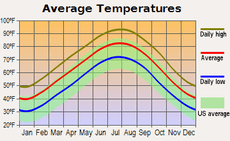 Temperature averages for each month. |
|
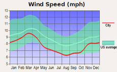 Wind speeds during the various months. | |
See also

Notes
- Mean monthly maxima and minima (i.e. the expected highest and lowest temperature readings at any point during the year or given month) calculated based on data at said location from 1981 to 2010.
- Official records for Little Rock began on 28 February 1875 at the State Capitol and maintained there until 30 April 1942. The next day, and until 7 August 1942, temperature and precipitation were recorded separately at two different locations in and around Little Rock, and the official climatology station has been Adams Field since 8 August 1942. For more information, see Threadex
References
- "NowData – NOAA Online Weather Data". National Oceanic and Atmospheric Administration. Retrieved 2018-10-18.
- "Station Name: AR LITTLE ROCK AP ADAMS FLD". National Oceanic & Atmospheric Administration. Retrieved 2014-03-28.
- "NOAA". NOAA.
- "Monthly Averages for Little Rock, AR (72201)". The Weather Channel. Retrieved 2012-02-17.