Camino of Rancho San Antonio
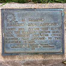
The Camino of Rancho San Antonio is a former road that was located in Alameda County, California. The camino originally reached from Fruitvale to Mission San José.[1] It eventually expanded to travel from the Temescal area of Oakland to San Pablo.[1]
| Camino of Rancho San Antonio | |
|---|---|
 | |
| Location | SW corner of Oakland and Santa Clara Aves. Oakland, California |
| Coordinates | 37.824444°N 122.258889°W |
| Designated | March 22, 1939[1] |
| Reference no. | 299[1] |
 Location in Oakland/East Bay | |
History
The historical road transported users from Fruitvale to Mission San José. Eventually, it expanded further north through Oakland to the Temescal neighborhood, and the towns of San Leandro and San Lorenzo, and finally San Pablo.[2]
A portion of the old camino was visible, as depressions left from wheels that once used the road, until 1870 around 60 Santa Clara Avenue in Oakland. A section of Santa Clara Avenue, near Grand Avenue to Harrison Street, travels along the camino route.[2]
Legacy
Camino of Rancho San Antonio is no longer a functioning road. It is listed on the California Historical Landmarks listing as #299.[1]
See also

References
- "Camino of Rancho San Antonio". Office of Historic Preservation, California State Parks. Retrieved 2012-10-05.
- Abeloe, William N. (1966). Historic Spots in California (3rd ed.). Stanford, CA: Stanford University Press. p. 11. ISBN 978-0-8047-4020-3. Retrieved August 29, 2012.