Callejones
Callejones is a barrio in the municipality of Lares, Puerto Rico. Its population in 2010 was 4,575.[3][4][5] Machos Cave (Spanish: Cueva Machos) and Pajita Cave (Spanish: Cueva Pajita) are located in Callejones.[6]
Callejones | |
|---|---|
Barrio | |
 Callejones street sign | |
 Location of Callejones barrio within the municipality of Lares shown in red | |
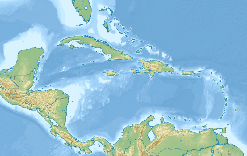 Callejones Location of Puerto Rico | |
| Coordinates: 18°19′38″N 66°50′56″W[1] | |
| Commonwealth | |
| Municipality | |
| Area | |
| • Total | 8.39 sq mi (21.7 km2) |
| • Land | 8.39 sq mi (21.7 km2) |
| • Water | 0 sq mi (0 km2) |
| Elevation | 1,207 ft (368 m) |
| Population (2010) | |
| • Total | 4,575 |
| • Density | 545.3/sq mi (210.5/km2) |
| Source: 2010 Census | |
| Time zone | UTC−4 (AST) |
History
The United States took control of Puerto Rico from Spain in the aftermath of the Spanish-American War under the terms of the Treaty of Paris of 1898. In 1899, the US conducted its first census of Puerto Rico finding that the population of Callejones barrio was 2,152.[7]
Sectors
Barrios (which are like minor civil divisions)[8] in turn are further subdivided into smaller local populated place areas/units called sectores (sectors in English). The types of sectores may vary, from normally sector to urbanización to reparto to barriada to residencial, among others.[9][10][11]
The following sectors are in Callejones barrio:[12]
Arco Iris, Berrocal, Camino Emau, Camino Julito Nieves, Carmelo Mercado, Copa de Oro, Demetrio Otaño, El Maná, Las Lajas, Los Adames, Los Chayotes, Los Luciano, Los Otaño, Miro Torres, Monchín Rivera, Sector Crematorio, Sector Cueva Pajita, Sector El 21, Sector El Taino, Sector Gregorio Rivera, Sector La Gallera, Sector La Pista, Sector La Sierra, Sector Las Campanas, Sector León Vega, Sector Los Nieves, Sector Los Santiago, Sector Pagán, Sector Pedro Colón, Sector Zenón Rivera, Sico Torres, Tramo Carretera 129, Tramo Carretera 134, and Tramo Carretera 454.
Archeological site
An archeological site consisting of a batey (a large clearing where ceremonies took place) is located in Callejones.[13] It is of the Early Ostionoid (pre-Taino) (AD 600-1200) and Late Ostionoid (Taino) (AD 1200-1500) prehistoric eras and has been researched by Jose Oliver, a researcher from Yale University,[14] and Samuel Kirkland Lothrop.[15]
References
- "US Gazetteer 2019". US Census. US Government.
- U.S. Geological Survey Geographic Names Information System: Callejones barrio
- Picó, Rafael; Buitrago de Santiago, Zayda; Berrios, Hector H. Nueva geografía de Puerto Rico: física, económica, y social, por Rafael Picó. Con la colaboración de Zayda Buitrago de Santiago y Héctor H. Berrios. San Juan Editorial Universitaria, Universidad de Puerto Rico,1969.
- Gwillim Law (20 May 2015). Administrative Subdivisions of Countries: A Comprehensive World Reference, 1900 through 1998. McFarland. p. 300. ISBN 978-1-4766-0447-3. Retrieved 25 December 2018.
- Puerto Rico:2010:population and housing unit counts.pdf (PDF). U.S. Dept. of Commerce, Economics and Statistics Administration, U.S. Census Bureau. 2010.
- "Lares: Ciudad de cielos abiertos". Nueva Isla (in Spanish). SG Communications.
- Joseph Prentiss Sanger; Henry Gannett; Walter Francis Willcox (1900). Informe sobre el censo de Puerto Rico, 1899, United States. War Dept. Porto Rico Census Office (in Spanish). Imprenta del gobierno. p. 160.
- "US Census Barrio-Pueblo definition". factfinder.com. US Census. Archived from the original on 13 May 2017. Retrieved 5 January 2019.
- "Agencia: Oficina del Coordinador General para el Financiamiento Socioeconómico y la Autogestión (Proposed 2016 Budget)". Puerto Rico Budgets (in Spanish). Retrieved 28 June 2019.
- Rivera Quintero, Marcia (2014), El vuelo de la esperanza: Proyecto de las Comunidades Especiales Puerto Rico, 1997-2004 (first ed.), San Juan, Puerto Rico Fundación Sila M. Calderón, ISBN 978-0-9820806-1-0
- "Leyes del 2001". Lex Juris Puerto Rico (in Spanish). Retrieved 24 June 2020.
- "PRECINTO ELECTORAL LARES 053" (PDF). Comisión Estatal de Elecciones (in Spanish). PR Government. 14 June 2019. Retrieved 19 June 2019.
- "Archived copy". Archived from the original on 2019-06-26. Retrieved 2019-06-26.CS1 maint: archived copy as title (link)
- Oliver, José R.; Rivera Fontán, Juan. "(2007) -NRHP Bateyes de Vivi (U-1), Utuado, Puerto Rico". Academia. Retrieved 26 June 2019.
- "CALLEJONES SITE" (PDF). Agencias PR Gov. United States Department of the Interior, National Park Service. Retrieved 26 June 2019.