California Historical Landmarks in Siskiyou County, California
This list includes properties and districts listed on the California Historical Landmark listing in Siskiyou County, California. Click the "Map of all coordinates" link to the right to view a Google map of all properties and districts with latitude and longitude coordinates in the table below.
width = 8% class="unsortable" style="background-color:
|
style="background-color:
|
width = 18% style="background-color:
|
style="background-color:
|
City or town | style="background-color:
|
|---|---|---|---|---|---|
style="background-color:
|
Canby's Cross | Lava Beds National Monument 41°49′18″N 121°30′18″W |
Tulelake | ||
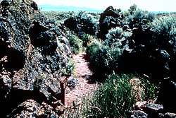 Captain Jack's Stronghold |
style="background-color:
|
Captain Jack's Stronghold | Lava Beds National Monument 41°52′47″N 121°21′56″W |
Tulelake | Coordinates bring visitor to the marker not the actual cross (cross directions on marker) |
style="background-color:
|
Emigrant Crossing of present highway | State Hwy 97 at Military Pass Rd. |
Weed | ||
style="background-color:
|
Fort Jones | Fort Jones, California |
Fort Jones | ||
style="background-color:
|
Guillem's Graveyard | Lava Beds National Monument |
Tulelake | ||
style="background-color:
|
Strawberry Valley Station | W. Jessie St. and Old Stage Rd. |
Mt. Shasta | ||
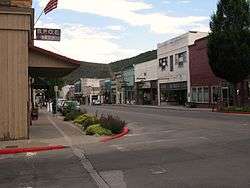 West Miner Street-Third Street Historic District |
style="background-color:
|
West Miner Street-Third Street Historic District | Historic district 41°43′36″N 122°38′15″W |
Yreka |
References
- "California Historical Landmarks By County". Ohp.parks.ca.gov. Retrieved 2019-04-03.
See also
| Wikimedia Commons has media related to California Historical Landmarks in Siskiyou County, California. |
- List of California Historical Landmarks
- National Register of Historic Places listings in Siskiyou County, California
| |||||||||||||||||||||
| |||||||||||||||||||||
| |||||||||||||||||||||
| |||||||||||||||||||||
| |||||||||||||||||||||
| |||||||||||||||||||||
| |||||||||||||||||||||
| |||||||||||||||||||||
This article is issued from Wikipedia. The text is licensed under Creative Commons - Attribution - Sharealike. Additional terms may apply for the media files.