California Historical Landmarks in San Benito County, California
List table of the properties and districts — listed on the California Historical Landmarks — within San Benito County, Northern California.
- Note: Click the "Map of all coordinates" link to the right to view a Google map of all properties and districts with latitude and longitude coordinates in the table below.
Listings
width = 8% class="unsortable" style="background-color:
|
style="background-color:
|
width = 18% style="background-color:
|
style="background-color:
|
City or town | style="background-color:
|
|---|---|---|---|---|---|
Fremont Peak |
style="background-color:
|
Fremont Peak | Fremont Peak State Park 36°45′26″N 121°30′15″W |
San Juan Bautista | |
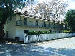 Jose Castro House |
style="background-color:
|
Jose Castro House | San Juan Bautista State Historic Park 36°50′41″N 121°32′09″W |
San Juan Bautista | |
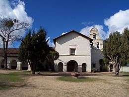 Mission San Juan Bautista |
style="background-color:
|
Mission San Juan Bautista | 2nd and Mariposa Sts. 36°50′42″N 121°32′09″W |
San Juan Bautista | |
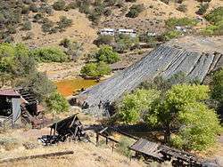 New Idria Mine |
style="background-color:
|
New Idria Mine | 36°25′01″N 120°40′24″W |
New Idria | |
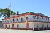 Plaza Hotel |
style="background-color:
|
Plaza Hotel | San Juan Bautista State Historic Park 36°50′42″N 121°32′10″W |
San Juan Bautista |
References
- "California Historical Landmarks By County". Ohp.parks.ca.gov. Retrieved 2019-04-03.
See also
| Wikimedia Commons has media related to California Historical Landmarks in San Benito County, California. |
- List of California Historical Landmarks
- National Register of Historic Places listings in San Benito County, California
| |||||||||||||||||||||
| |||||||||||||||||||||
| |||||||||||||||||||||
| |||||||||||||||||||||
| |||||||||||||||||||||
| |||||||||||||||||||||
| |||||||||||||||||||||
| |||||||||||||||||||||
This article is issued from Wikipedia. The text is licensed under Creative Commons - Attribution - Sharealike. Additional terms may apply for the media files.