California Historical Landmarks in Sacramento County, California
This list includes properties and districts listed on the California Historical Landmark listing in Sacramento County, California. Click the "Map of all coordinates" link to the right to view a Google map of all properties and districts with latitude and longitude coordinates in the table below.
width = 8% class="unsortable" style="background-color:
|
style="background-color:
|
width = 18% style="background-color:
|
style="background-color:
|
City or town | style="background-color:
|
|---|---|---|---|---|---|
style="background-color:
|
Adams and Company Building | Old Sacramento Historic District, 1014 2nd St. |
Sacramento | ||
 African Methodist Episcopal Church |
style="background-color:
|
African Methodist Episcopal Church | 715 Seventh St. 38°35′03″N 121°29′46″W |
Sacramento | |
 B.F. Hastings Building |
style="background-color:
|
B.F. Hastings Building | Old Sacramento State Historic Park, 1000 2nd St. 38°34′59″N 121°30′15″W |
Sacramento | |
 Booth Company |
style="background-color:
|
Booth Company | 1015-17 Front St. 38°35′00″N 121°30′20″W |
Sacramento | |
style="background-color:
|
California Almond Growers exchange process facility | 1809 C St. 38°35′06″N 121°28′43″W |
Sacramento | ||
style="background-color:
|
California’s First Passenger Railroad | 3rd and R Sts. 38°34′26″N 121°30′24″W |
Sacramento | ||
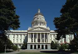 California State Capitol |
style="background-color:
|
California State Capitol | 10th St and Capitol Mall 38°34′36″N 121°29′36″W |
Sacramento | |
style="background-color:
|
Camp Union, Sutterville | Sutterville and Land Park Dr. 38°32′16″N 121°30′15″W |
Sacramento | ||
style="background-color:
|
Chevra Kaddisha Cemetery | 3230 J St. |
Sacramento | ||
style="background-color:
|
China Slough | Sacramento Station |
Sacramento | ||
style="background-color:
|
Coloma Road - Nimbus Dam | Folsom Lake State Recreation Area |
Granite Bay | ||
style="background-color:
|
Coloma Road - Sutter's Fort | 28th and L Sts. 38°34′19″N 121°28′13″W |
Sacramento | ||
style="background-color:
|
D.O. Mills Bank Building | Old Sacramento State Historic Park, 2nd and J Sts |
Sacramento | ||
 E.B. Crocker Art Gallery |
style="background-color:
|
E.B. Crocker Art Gallery | 216 O St. 38°34′37″N 121°30′18″W |
Sacramento | |
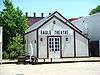 Eagle Theatre (Sacramento, California) |
style="background-color:
|
Eagle Theatre (Sacramento, California) | Old Sacramento State Historic Park, 925 Front St 38°35′01″N 121°30′19″W |
Sacramento | |
 First and second state capitols |
style="background-color:
|
First and second state capitols | 7th and I Sts. 38°34′57″N 121°29′49″W |
Sacramento | |
 Ebner's Hotel |
style="background-color:
|
Ebner's Hotel | 116 1/2 K St. |
Sacramento | |
style="background-color:
|
Elk Grove Free Library | 9125 Elk Grove Blvd. 38°24′33″N 121°21′41″W |
Elk Grove | ||
style="background-color:
|
Fifteen Mile House - Overland Pony Express Route | White Rock & Gold Valley Rds. |
Rancho Cordova | ||
 First Jewish Synagogue owned by a congregation on the west coast |
style="background-color:
|
First Jewish Synagogue owned by a congregation on the west coast | 7th St between Capitol and L 38°34′41″N 121°29′57″W |
Sacramento | |
style="background-color:
|
Five Mile House - Overland Pony Express Route | California State University, 6000 "J" St., left on State University Drive East to Guy West Bridge over-crossing and plaza. Plaque located in plaza. |
Sacramento | ||
style="background-color:
|
Folsom - Overland Pony Express Route | 819 Sutter St. |
Folsom | ||
style="background-color:
|
Folsom Terminal | Leidesdorff Plaza 38°40′33″N 121°10′49″W |
Sacramento | ||
 Folsom Powerhouse |
style="background-color:
|
Folsom Powerhouse | Folsom Powerhouse State Historic Park 38°40′50″N 121°10′32″W |
Folsom | |
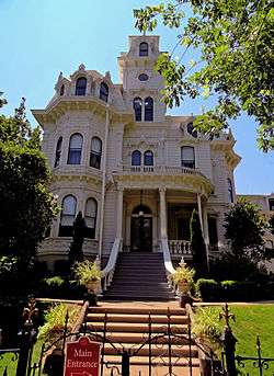 Governor's Mansion |
style="background-color:
|
Governor's Mansion | Governor's Mansion State Historic Park 38°34′49″N 121°29′01″W |
Sacramento | |
style="background-color:
|
Grave of Alexander Hamilton Willard | Franklin Cemetery 38°22′37″N 121°27′22″W |
Franklin | ||
style="background-color:
|
Grave of Elitha Cumi Donner Wilder | Elk Grove Masonic Cemetery, Row C, Lot 2 38°24′31″N 121°23′07″W |
Elk Grove | ||
 Lady Adams Building |
style="background-color:
|
Lady Adams Building | Old Sacramento Historic District, 117-19 K St. 38°34′57″N 121°30′19″W |
Sacramento | |
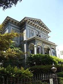
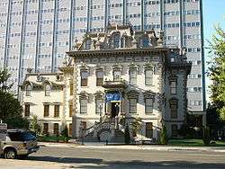 Leland Stanford Mansion State Historic Park |
style="background-color:
|
Leland Stanford Mansion State Historic Park | 800 N St. 38°34′34″N 121°29′52″W |
Sacramento | |
Michigan Bar |
style="background-color:
|
Michigan Bar | State Hwy 16. 38°29′10″N 121°03′11″W |
Rancho Murieta | |
style="background-color:
|
Murphy's Corral | Grant Line Rd and Hwy 99 38°22′29″N 121°21′43″W |
Elk Grove | Also called Murphy's Ranch | |
style="background-color:
|
New Helvetia Cemetery | Alhambra Blvd. and J St. 38°34′22″N 121°27′54″W |
Sacramento | ||
style="background-color:
|
Nisipowinan | Address restricted |
Sacramento | ||
 Old Folsom Powerhouse Station |
style="background-color:
|
Old Folsom Powerhouse Station | NE corner of 6th and H Sts 38°35′02″N 121°29′52″W |
Sacramento | |
 Old Sacramento |
style="background-color:
|
Old Sacramento | Old Sacramento State Historic Park 38°34′58″N 121°30′12″W |
Sacramento | |
Original Sacramento Bee building |
style="background-color:
|
Original Sacramento Bee building | Under N-bound offramp of I-5, W side of 3rd St between J and K Sts |
Sacramento | |
style="background-color:
|
Orleans Hotel | Old Sacramento Historic District, 1018 2nd St. |
Sacramento | ||
style="background-color:
|
Overton Building | Old Sacramento State Historic Park, 2nd and J Sts. |
Sacramento | ||
style="background-color:
|
Pioneer Congregational United Church of Christ | 915 6th St. |
Sacramento | ||
style="background-color:
|
Pioneer Mutual Volunteer Firehouse | 200 ft NE of intersection of 3rd and J Sts |
Sacramento | ||
style="background-color:
|
Prairie City | Prairie City Rd, 500 ft N of State Hwy 50 38°38′37″N 121°09′26″W |
Folsom | ||
style="background-color:
|
Pioneer Telegraph Station | 1015-2nd St, Old Sacramento 38°34′57″N 121°30′15″W |
Sacramento | ||
style="background-color:
|
Sacramento Assembly Center aka Camp Kohler | Walerga Park 38°40′06″N 121°21′05″W |
Sacramento | ||
 Sacramento Historic City Cemetery |
style="background-color:
|
Sacramento Historic City Cemetery | Broadway and 10th Sts. 38°33′49″N 121°30′03″W |
Sacramento | |
style="background-color:
|
Sacramento Union | Old Sacramento Historic District, 121 J St. |
Sacramento | ||
style="background-color:
|
Sheldon Grist Mill | Meiss Rd and Hwy 16 38°29′47″N 121°11′50″W |
Sloughhouse | ||
style="background-color:
|
Site of Stage and Railroad | Old Sacramento State Historic Park |
Sacramento | ||
_Wiki.jpg) Sam Brannan House |
style="background-color:
|
Sam Brannan House | Old Sacramento Historic District, 112 J. St. |
Sacramento | |
style="background-color:
|
Sloughhouse | Meiss St & Hwy 16. 38°29′47″N 121°11′47″W |
Sacramento | ||
style="background-color:
|
State Indian Museum | 2618 K St. |
Sacramento | ||
style="background-color:
|
Sutterville | Sutterville Rd, vicinity of Land Park Dr. 38°32′45″N 121°30′30″W |
Sacramento | ||
style="background-color:
|
Sutter's Landing | 28th and C Sts. 38°34′53″N 121°27′57″W |
Sacramento | ||
style="background-color:
|
First Transcontinental Railroad | Old Sacramento State Historic Park, California State Railroad Museum |
Sacramento | ||
style="background-color:
|
First Transcontinental Railroad - Western base of Sierra Nevada | Haggin Oaks Municipal Golf Course, N side of clubhouse, 3645 Fulton Ave. |
Sacramento | ||
style="background-color:
|
Western Hotel | Parking lot, 200 ft NE of intersection of 2nd and K Sts. |
Sacramento | ||
style="background-color:
|
What Cheer House | Front and K Sts. |
Sacramento |
References
- "California Historical Landmarks By County". Ohp.parks.ca.gov. Retrieved 2019-04-03.
See also
| Wikimedia Commons has media related to California Historical Landmarks in Sacramento County, California. |
This article is issued from Wikipedia. The text is licensed under Creative Commons - Attribution - Sharealike. Additional terms may apply for the media files.