Cabo Touriñán
Cabo Touriñán is a small peninsula that is the most westerly point of Peninsular Spain.[1] It is located in the municipality of Muxía.
Description
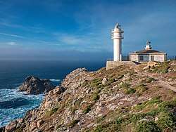
The cape is a small peninsula that juts about 1 km into the sea, the narrowest section being an isthmus 150 metres wide between the coasts of Balal and Cuño. Its maximum altitude is 93 metres above sea level. The rock it's made of is granite, the erosion of which has caused the formation of deposits of pebbles, known as coídos, and stony bars, forming an islet such as the so-called A Ínsua on the west side of the cape. The western point of the cape, called Os Buxeirados, has a series of rocks that go into the sea around 300 to 400 metres, known as A Laxe de Buxeirados or Bajos de Buxeirados. These rocks have proved dangerous for navigation, causing some serious shipwrecks. Due to its rugged landscape, the vegetation of the cape is basically just thorny reed or gorse like Ulex eruopaeus. In the northern part of the cape, there is a lighthouse and complementary buildings established 15 December 1898.[2]
Name
The name comes from the nearby parish of Touriñán, in which the cape is located, and that must go back to the Latin name, which is supposed to be "Taurinius" or "Taurinianus" through the genitive "Tauriniani".
Gallery
 Illa do Castelo.

See also
- Cape Finisterre
- Extreme points of Spain
- Touriñán Lighthouse
References
- Molina, César Antonio (Nov 2003). Viaje a la costa de la muerte (in Spanish). Huerga Y Fierro Editores. p. 222. ISBN 978-8483743904. Retrieved 26 April 2015.
- José., Baña Heim (D.L. 1980). Viaje a la Costa de la Muerte con la historia y anecdotario de sus naufragios. Venus (4a. ed. rev. y aum ed.). [S.l.]: J. Baña. ISBN 8440400285. OCLC 434519936. Check date values in:
|date=(help)CS1 maint: ignored ISBN errors (link)