Cabeço Gordo
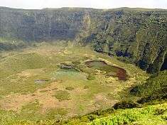
Cabeço Gordo (Portuguese for "fat mountain") is the highest mountain, massive stratovolcano and the largest geomorphological structure that forms the island of Faial. The mountain/volcano is 1,043 meters above sea level, consisting of a two kilometer wide caldera, that is 400 m in depth below the crater rim. From Cabeço Gordo, on a clear day, the islands of the central group of the Azores are visible: Pico, Sao Jorge, and Graciosa, although normally the caldera may be covered in clouds and fog.
| Cabeço Gordo | |
|---|---|
| Caldeira | |
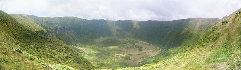 The Caldeira crater of Cabeço Gordo, located on the island of Faial | |
| Highest point | |
| Elevation | 1,043 m (3,422 ft) |
| Prominence | 1,043 m (3,422 ft) |
| Coordinates | 38°35′08″N 28°42′52″W |
| Naming | |
| English translation | fat mountain |
| Language of name | Portuguese |
| Geography | |
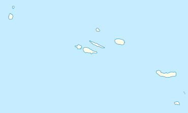 Cabeço Gordo Location of Cabeço Gordo, relative the islands of the Azores | |
| Location | Azores, Portugal |
| Parent range | Mid-Atlantic Ridge |
| Geology | |
| Age of rock | 470,000 - 11,000 Years |
| Mountain type | Volcanic crater/Stratovolcano |
| Last eruption | 1958 |
| Climbing | |
| Easiest route | YDS Grade I |
History
Along the western edge of the Ribeirinha Volcano, the Central Volcanic Complex formed about 410,000 years ago,[1] along with several structures that arose from tectonics. Evidence of this process has not been preserved due to subsistence, but it is generally believed[2] that two formations (an Upper and Lower group) reflecting a geochemical variation that occurred about 16,000 years ago. The Lower group (from 410,000 years ago), was marked by the predominance of a Hawaiian/Strombolian eruptive process, that was composed of basaltic and benmoreitic rocks. The secondary, Upper group, was a highly explosive period (sub-Plinian in character), which produced a series of twelve deposits of pumice and surge deposits (pyroclastic flows of trachytic and benmoreitic).
Although the central volcano has not been active within the past two centuries, it has seen activity related to the eruption of Capelinhos (1957–58). During this period, fumaroles in the caldera became active, and the minor lakes/swamps were dried-up by excessive heat.
Cabeço Gordo, due to its central nature, is part of each parish on the island (except for Matriz, Conceição and Angustias).
Geography
Cabeço Gordo is the main geomorphological unit, corresponding to a polygenetic volcano two kilometers at the top and one kilometer at the base. The walls of the crater rim are abrupt, although their slopes increase with altitudes. The superficial cover of the volcano is covered in pyroclastic material, such as pumice rock, phreatic and phreatomagmatic deposits, evidence of pyroclastic flows and lahars. The flanks of the stratovolcano also include the Morro de Castelo Branco and peninsula of denser material that have resisted erosion.
References
- Notes
- Serralheiro et al, 1989
- Pacheco, 2001
- Sources
- "Fayal". Global Volcanism Program. Smithsonian Institution.
- Pacheco, J. (2001), Processos associados ao desenvolvimento de erupções vulcânicas hidromagmáticas na ilha do Faial e sua interpretação numa perspectiva de availação do hazard e minimização do risco [Associated Processes in the Hydromagmatic Eruptions of Volcanoes on the island of Faial and their Interpretation for the Evaluation of Hazards and Minimization of Risk] (in Portuguese), Ponta Delgada, Azores: Departamento de Geociencias, Universidade dos Açores
- Serralheiro, A.; Matos Alves, C.A.; Forjaz, Victor Hugo; Rodrigues, B. (1989), Carta Vulcanológica dos Açores: ilha do Faial à escala 1:15000 [Volcanological Map of the Azores: Island of Faial (Scale: 1:15000)] (in Portuguese), Universidade dos Açores e Centro de Vulcanologia do INIC
- Machado, Adriane; Azevedo, José M. M.; Alemeida, Delia P.M.; Farid Chemale Jr. (2008). "Geochemistry of Volcanic Rocks from Faial Island (Azores)" (PDF). 5, 1. Lisbon: e-Terra, GEOTIC – Sociedade Geológica de Portugal: 1–14. Archived from the original (PDF) on 2011-05-11. Retrieved 2010-08-22. Cite journal requires
|journal=(help)