Brighton Airport
Brighton Airport (FAA LID: 45G) is a public use airport located three nautical miles (6 km) north of the central business district of Brighton, in Livingston County, Michigan, United States.[1]
Brighton Airport | |||||||||||
|---|---|---|---|---|---|---|---|---|---|---|---|
 Airport runway area | |||||||||||
| Summary | |||||||||||
| Airport type | Public | ||||||||||
| Owner/Operator | Brighton Airport Association | ||||||||||
| Serves | Brighton, Michigan | ||||||||||
| Elevation AMSL | 973 ft / 297 m | ||||||||||
| Coordinates | 42°34′11″N 083°46′43″W | ||||||||||
| Website | BrightonAirport.org | ||||||||||
| Runways | |||||||||||
| |||||||||||
| Statistics (2008) | |||||||||||
| |||||||||||

The airport opened in July 1947[3] and is used primarily for privately owned light recreational aircraft, however it is open to the public.[2] It is owned by the Brighton Airport Association, a not-for-profit organization,[4] and managed by William Bertrand.
Facilities and aircraft
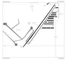
Brighton Airport covers an area of 47 acres (19 ha) at an elevation of 973 feet (297 m) above mean sea level. It has one runway designated 4/22 with an asphalt surface measuring 3,120 by 24 feet (951 x 7 m).[1]
For the 12-month period ending December 31, 2008, the airport had 17,600 general aviation aircraft operations, an average of 48 per day. At that time there were 91 aircraft based at this airport: 98% single-engine, 1% multi-engine and 1% ultralight.[1]
Notable projects
Brighton Airport is home to two major projects. One of which is a B-25 restoration project run by the Warbirds of Glory Museum [5] Build a Plane project where youth
References
- FAA Airport Master Record for 45G (Form 5010 PDF). Federal Aviation Administration. effective 29 July 2010.
- FAA Airports GIS for 45G
- Brighton Airport (45G) at AirNav
- Brighton Airport, official website
- There is also the Brighton
External links
| Wikimedia Commons has media related to Brighton Airport. |
- Brighton Airport, official website
- Brighton Field (45G) airport diagram from Michigan DOT
- Aerial image as of 28 April 1992 from USGS The National Map
- Resources for this airport:
- FAA airport information for 45G
- AirNav airport information for 45G
- FlightAware airport information and live flight tracker
- SkyVector aeronautical chart for 45G