Black River (North Carolina)
The Black River is a tributary of the Cape Fear River, approximately 50 mi (80 km) long, in southeastern North Carolina in the United States.
| Black River Tributary to Cape Fear River | |
|---|---|
 | |
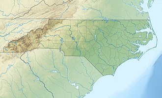 Location of Black River mouth | |
| Location | |
| Country | United States |
| State | North Carolina |
| Counties | Bladen Pender Sampson |
| Physical characteristics | |
| Source | confluence of Six Runs Creek and Great Coharie Creek |
| • location | about 3 NW of Clear Run, North Carolina |
| • coordinates | 34°47′23″N 078°18′45″W[1] |
| • elevation | 44 ft (13 m)[2] |
| Mouth | Cape Fear River |
• location | Wilmington, North Carolina[2] |
• coordinates | 34°19′55″N 078°01′57″W[1] |
• elevation | 0 ft (0 m)[2] |
| Length | 53.1 mi (85.5 km)[3] |
| Basin size | 1,417.37 square miles (3,671.0 km2)[4] |
| Discharge | |
| • location | Wilmington, North Carolina |
| • average | 1,609.9 cu ft/s (45.59 m3/s) at mouth with Cape Fear River[4] |
| Basin features | |
| Progression | generally southeast |
| River system | Cape Fear River |
| Tributaries | |
| • left | Six Runs Creek Clear Run Big Run Canty Mill Creek Wildcat Creek Kings Branch Haw Mill Creek Colvins Creek Moores Creek Bear Branch Cane Creek Cross Way Creek Machine Creek |
| • right | Great Coharie Creek Devane Branch Keith Branch South River Rowan Creek Colly Creek Lyon Creek Line Creek |
It is formed in southern Sampson County, approximately 15 mi. (24 km) south of Clinton, by confluence of two creeks: Great Coharie Creek and Six Runs Creek.[2] It flows SSE, receiving the South River approximately 30 mi (48 km) south of Clinton. It flows southeast through Pender County, past the Moores Creek National Battlefield, and joins the Cape Fear approximately 10 mi (16 km) northwest of Wilmington, near the broadening of the Cape Fear into a tidal estuary.
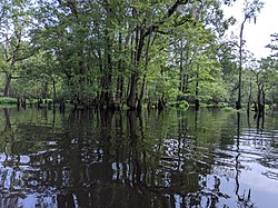
The river is known for having a wide variety of fish species, ranging from several types of sunfish and catfish, as well as largemouth bass. Ancient Bald cypress trees in excess of 2600 years old were discovered along the river in 2019.[5]
See also
- List of North Carolina rivers
References
- "GNIS Detail - Black River". geonames.usgs.gov. US Geological Survey. Retrieved 23 July 2019.
- "Black River Topo Map, Pender County NC (Leland Area)". TopoZone. Locality, LLC. Retrieved 31 July 2019.
- "ArcGIS Web Application". epa.maps.arcgis.com. US EPA. Retrieved 23 July 2019.
- "Black River Watershed Report". Waters Geoviewer. US EPA. Retrieved 23 July 2019.
- "A 2,624-Year-Old Tree Has Just Been Found Growing in a Swamp in America". ScienceAlert. 10 May 2019.
Further reading
- Burgess, Carla B. (March–April 1994). "Waking to the River". Coastwatch. pp. 2–9. ISSN 1068-784X – via Internet Archive.
- Hart, Kathy (March–April 1994). "The Legend of Black Beauty". Coastwatch. pp. 10–15. ISSN 1068-784X – via Internet Archive.
- Faris, Jeannie (March–April 1994). "The Black River and Beyond: Old Forests May Be Last Refuge for Rare Bat". Coastwatch. pp. 16–21. ISSN 1068-784X – via Internet Archive.