Atoyac de Álvarez (municipality)
Atoyac de Álvarez is one of the 81 municipalities of Guerrero, in south-western Mexico. The municipal seat lies at Atoyac de Álvarez. The municipality covers an area of 1638.4 km².
Atoyac de Álvarez | |
|---|---|
Municipality | |
 Coat of arms | |
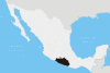
 Municipality of Atoyac de Álvarez in Guerrero | |
Atoyac de Álvarez Location in Mexico | |
| Coordinates: 17°03′N 100°05′W | |
| Country | |
| State | Guerrero |
| Municipal seat | Atoyac de Álvarez |
| Area | |
| • Total | 1,638.4 km2 (632.6 sq mi) |
| Population (2005) | |
| • Total | 58,452 |
Geography
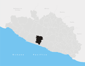
Atoyac is located on the Costa Grande of the state of Guerrero, about 84 kilometers west of the port of Acapulco, which is the main city of the state. It has an extension of 1,638.4 km2. It limits to the north with San Miguel Totolapan, Ajuchitlán del Progreso and General Heliodoro Castillo; to the east with Coyuca de Benítez; to the west with Tecpan de Galeana and to the south with Benito Juárez. The extreme coordinates of the municipality are 17 ° 03 '- 18 ° 32' north latitude, and 100 ° 05 '- 100 ° 34' west longitude.
In 2005, the municipality had a total population of 58,452.[1]
References
- "Atoyac de Álvarez". Enciclopedia de los Municipios de México. Instituto Nacional para el Federalismo y el Desarrollo Municipal. Archived from the original on September 30, 2007. Retrieved December 23, 2008.
Chilpancingo (capital) | |
| Municipalities/ (seats) |
|