Ashmore and Cartier Islands
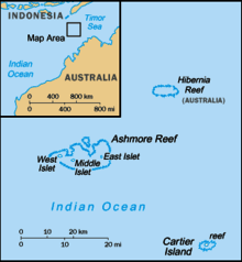
The Territory of Ashmore and Cartier Islands[1] is an uninhabited external territory[2] of Australia consisting of four low-lying tropical islands in two separate reefs, and the 12-nautical-mile (22 km; 14 mi) territorial sea generated by the islands.[3] The territory is located in the Indian Ocean situated on the edge of the continental shelf, about 320 km (199 mi) off the northwest coast of Australia and 144 km (89 mi) south of the Indonesian island of Rote.[3]
.svg.png) Location of the Ashmore and Cartier Islands | |
| Geography | |
|---|---|
| Location | Indian Ocean |
| Coordinates | |
| Major islands | 4 |
| Administration | |
| Demographics | |
| Population | 0 (1 January 2011) |
Ashmore Reef is called Pulau Pasir by Indonesians and Nusa Solokaek in the Rotenese language. Both names have the meaning "sand island".[4]
Geography
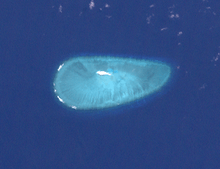
The Territory comprises Ashmore Reef, which includes West, Middle, and East Islands, and two lagoons, and Cartier Reef, which includes Cartier Island. Ashmore Reef covers approximately 583 km2 (225.1 sq mi) and Cartier Reef 167 km2 (64 sq mi), both measurements extending to the limits of the reefs.[5]
West, Middle, and East Islands have a combined land area variously reported as 54 hectares (130 acres),[6] 93 hectares (230 acres)[7] and 112 hectares (280 acres).[8] Cartier Island has a reported land area of 0.4 hectares (0.99 acres).[7]
History
According to Australian literature[9], Cartier Island was discovered by Captain Nash in 1800, and named after his ship Cartier. Ashmore Island was discovered by Captain Samuel Ashmore in 1811 from his ship HMS Hibernia and named after him. Ashmore Island was annexed by the United Kingdom in 1878, as was Cartier Island in 1909.[10]
A British order-in-council dated 23 July 1931 stated that Ashmore and Cartier Islands would be placed under the authority of the Commonwealth of Australia when Australia passed legislation to accept them. The Commonwealth's resulting Ashmore and Cartier Islands Acceptance Act 1933 came into operation on 10 May 1934, when the islands formally became a territory. The act authorised the Governor of Western Australia to make ordinances for the territory. In July 1938 the territory was annexed to the Northern Territory, then also administered by the Commonwealth, whose laws, ordinances and regulations applied to the Territory. When self-government was granted to the Northern Territory on 1 July 1978, administration of Ashmore and Cartier Islands was retained by the Commonwealth.[3][11]
In 1983 the territory was declared a nature reserve under the National Parks and Wildlife Conservation Act 1975,[3] now replaced by the Environment Protection and Biodiversity Conservation Act 1999.[12]
After the islands became a first point of contact with the Australian migration zone, in September 2001, the Australian government excised the Ashmore and Cartier Islands from the Australian migration zone.[3]
Indonesian heritage and memorandum
Ashmore has been regularly visited and fished by Indonesian fishermen since the early eighteenth century. A 1974 Memorandum of Understanding (MOU) between Australia and Indonesia sets out arrangements by which traditional fishers can access resources in Australia's territorial sea in the region. This allows traditional Indonesian fishermen to access parts of Ashmore for shelter, freshwater and to visit grave sites. The area, known as the MOU Box, contains the Ashmore and Cartier Islands Territory.[13]
Governance
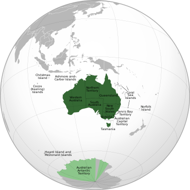
Today, the Territory is administered from Canberra by the Department of Infrastructure, Regional Development and Cities, which is also responsible for the administration of the territories of Christmas Island, Cocos (Keeling) Islands, the Coral Sea Islands, Jervis Bay Territory and Norfolk Island.[14]
The Attorney-General's Department had been responsible for the administration of Australian territories until the 2010 federal election. In that year the responsibility for Australian territories was transferred to the then Department of Regional Australia, Local Government, Arts and Sport,[3] and from 18 September 2013 the Department of Infrastructure and Regional Development has administered Australian territories.
Defence of Ashmore and Cartier Islands is the responsibility of Australia, with periodic visits by the Royal Australian Navy, Royal Australian Air Force and Australian Customs and Border Protection Service.
Nearby Hibernia Reef, 42 km (26 mi) northeast of Ashmore Reef, is not part of the Territory, but belongs to Western Australia.[15] It has no permanently dry land area, although large parts of the reef become exposed during low tide.
Environment and protection
The Ashmore Reef Marine Park and Cartier Island Marine Park are both classed as strict nature reserves (IUCN Ia) and protect biodiverse areas of significant and international importance, as well as cultural heritage.
Economy
There is no economic activity in the Territory, Ashmore and Cartier Islands being uninhabited. Cartier Island is an unvegetated sand island.[7] Access to Cartier Island is prohibited because of the risk of unexploded ordnances. There are no ports or harbours, only offshore anchorage. The customs vessel ACV Ashmore Guardian is stationed off the reef for up to 330 days per year.[16] The islands are also visited by seasonal caretakers and occasional scientific researchers.
The area has been a traditional fishing ground of Indonesian fishermen for centuries, and continues. In the 1850s, American whalers operated in the region. Mining of phosphate deposits took place on Ashmore Island in the latter half of the 19th century.[3] Today, all the wells in the Territory are infected with cholera or contaminated and undrinkable.[17]
Petroleum extraction activities take place at the Jabiru and Challis oil fields, which are adjacent to the Territory, and which are administered by the Northern Territory Department of Mines and Energy on behalf of the Commonwealth.[3]
Migration
As Ashmore Reef is the closest point of Australian territory to Indonesia, it was a popular target for people smugglers transporting asylum seekers en route to Australia.[18] Once they had landed on Ashmore Island, asylum seekers could claim to have entered Australian migration zone and request to be processed as refugees. The use of Ashmore Island for this purpose created great notoriety during late 2001, when refugee arrivals became a major political issue in Australia. The Australian Government argued that as Australia was not the country of first asylum for these "boat people", Australia did not have a responsibility to accept them.
A number of things were done to discourage the use of the Territory for this purpose, such as attempting to have the people smugglers arrested in Indonesia; the so-called Pacific Solution of processing them in third countries; the boarding and forced turnaround of the boats by Australian military forces; and finally excising the Territory and many other small islands from the Australian migration zone.
Two boatloads of asylum seekers were each detained for several days in the lagoon at Ashmore Island after failed attempts by the Royal Australian Navy to turn them back to Indonesia in October 2001.
See also
References
Notes
- The Central Intelligence Agency (2010). The World Factbook. Potomac Books, Inc. p. 39. ISBN 978-1-59797-541-4.
- "10: External territories". Legal Risk in International Transactions (ALRC Report 80). Australian Law Reform Commission (ALRC), Australian Government. 2006. ISBN 0642254877. Retrieved 14 April 2014.
- "Ashmore and Cartier Islands". Territories of Australia. Department of the Infrastructure and Regional Development, Australian Government. 29 January 2014. Retrieved 14 April 2014.
- "A STUDY OF SOCIO-ECONOMIC ISSUES FACING TRADITIONAL INDONESIAN FISHERS WHO ACCESS THE MOU BOX" (PDF). Archived from the original (PDF) on 27 August 2006.
- Australia, Geoscience. "Ashmore and Cariter Islands". Australian Government Geoscience Australia. Australian Government. Retrieved 21 February 2019.
- Carter, Mike; Clarke, Rohan; Pierce, Frank; Dooley, Sean; Swann, George; Grant, Murray (2010). "Lesser Coucal 'Centropus bengalensis' on Ashmore Reef: First Record for Australia". Australian Field Ornithology. 27 (3). ISSN 1448-0107.
Within the reef are three small islands: West, Middle and east Islands (total land area 54 ha). The largest and most heavily vegetated is West Island...
- Taylor & Francis Group (2004). The Europa World Year Book 2004 (45th ed.). Europa Publications, Taylor & Francis Group. p. 611. ISBN 978-1-85743-254-1.
- "Ashmore Reef National Nature Reserve and Cartier Island Marine Reserve". Marine Protected Areas. Department of Sustainability, Environment, Water, Population and Communities, Australian Government. Archived from the original on 9 July 2011.
- "Pulau Pasir (Ashmore Reef) belongs to Indonesia". Retrieved 13 August 2019.
- Luscombe, Stephen (2019). "Ashmore and Cartier Islands". The British Empire. Retrieved 16 March 2019.
- Year Book Australia, 1981, p.2
- Environment Protection and Biodiversity Conservation Act 1999
- "Ashmore Reef and Cartier Island Commonwealth Marine Reserves: Information for visitors" (PDF). Commonwealth of Australia 2014. Retrieved 17 August 2018.
- Assistant Director, Territories and Disaster Reconstruction Division (16 June 2012). "Territories of Australia". Department of Regional Australia, Local Government, Arts and Sport. Archived from the original on 11 February 2011. Retrieved 7 February 2008.
- "States of Australia". p. Administrative Divisions of Countries. Retrieved 23 June 2011.
- "Australian Customs Vessel Ashmore Guardian" (PDF). Australian Customs and Border Protection Service.
- "Bizarre Happenings at Reef". Navy News. Royal Australian Navy. 28 June 1999. Archived from the original on 27 May 2013. Retrieved 27 August 2018.
- Anita Roberts "Don't let them drown" Inside Indonesia Apr–Jun 2001, vol. 64
External links
| Wikivoyage has a travel guide for Ashmore and Cartier Islands. |
| Wikimedia Commons has media related to Ashmore and Cartier Islands. |
- "Ashmore and Cartier Islands". The World Factbook. Central Intelligence Agency.
- Geoscience Australia—Ashmore and Cartier Islands
- Department of the Environment and Heritage—Ashmore Reef National Nature Reserve
- Department of the Environment and Heritage—Cartier Island Commonwealth Marine Reserve
- First on list of Australian islands
- "Ashmore Reef Belongs to Indonesia," posted on East Timor Action Network.
- "Ashmore Islands are member of ARABOSAI"
| ||||||||||||||||||||||||||||||||||||||||||||
.svg.png)