Arnhem Land tropical savanna
The Arnhem Land tropical savanna is a tropical and subtropical grasslands, savannas, and shrublands ecoregion in Australia's Northern Territory.[2]
| Arnhem Land tropical savanna | |
|---|---|
%2C_Kakadu_National_Park%2C_Nadap_Lookout_--_2019_--_4200.jpg) Nadap Lookout in Kakadu National Park | |
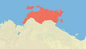 Map of the Arnhem Land tropical savanna ecoregion | |
| Ecology | |
| Realm | Australasian |
| Biome | tropical and subtropical grasslands, savannas, and shrublands |
| Borders | Carpentaria tropical savanna and Kimberley tropical savanna |
| Geography | |
| Area | 154,737 km2 (59,744 sq mi) |
| Country | Australia |
| States | Northern Territory |
| Conservation | |
| Conservation status | Relatively stable/intact |
| Protected | 55,398 km² (36%)[1] |
Geography
The ecoregion occupies the peninsula of Arnhem Land and its offshore islands, including the Tiwi Islands and Groote Eylandt.
It is bounded on the northwest by the Timor Sea, on the north by the Arafura Sea, and on the east by the Gulf of Carpentaria. The Kimberley tropical savanna ecoregion lies to the southwest, and the Carpentaria tropical savanna to the southeast.
IBRA regions
The ecoregion includes six IBRA regions – Arnhem Coast, Arnhem Plateau, Central Arnhem, Darwin Coastal, Pine Creek, and Tiwi Cobourg.
Protected areas
Protected areas in the ecoregion include Kakadu National Park, Djukbinj National Park, Nitmiluk National Park, and Garig Gunak Barlu National Park, and Litchfield National Park.
External links
- "Arnhem Land tropical savanna". Terrestrial Ecoregions. World Wildlife Fund.
References
- Eric Dinerstein, David Olson, et al. (2017). An Ecoregion-Based Approach to Protecting Half the Terrestrial Realm, BioScience, Volume 67, Issue 6, June 2017, Pages 534–545; Supplemental material 2 table S1b.
- "Arnhem Land tropical savanna". Terrestrial Ecoregions. World Wildlife Fund.