Arkansas Highway 392
Arkansas Highway 392 (also called AR 392 and Hwy. 392) is a 10.44-mile (16.80 km) state highway in the Ozark Mountains in northern Arkansas. The highway runs from U.S. Highway 62 (US 62) and US 412 in Little Arkansaw east to AR 7 in Harrison. The route is located entirely in Boone County, and also serves the communities of Batavia and Capps. AR 392 is maintained by the Arkansas State Highway and Transportation Department.
| ||||
|---|---|---|---|---|
| ||||
| Route information | ||||
| Maintained by ArDOT | ||||
| Length | 10.44 mi[1] (16.80 km) | |||
| Major junctions | ||||
| West end | ||||
| East end | ||||
| Location | ||||
| Counties | Boone | |||
| Highway system | ||||
| ||||

Route description
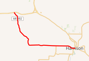
AR 392 begins at an intersection with US 62 and US 412 in Little Arkansaw, 3.2 miles (5.1 km) east of Alpena. From here the route heads south, leaving Little Arkansaw and heading through a rural area. The highway turns southeast to pass through Batavia; past the community, it briefly heads south before turning eastward. After passing through Capps, the road crosses the Dry Jordan Creek before meeting northbound AR 397. The two highways are briefly concurrent before AR 397 turns south; AR 392 continues eastward toward Harrison as Capps Road. In Harrison, the route enters a residential area before curving southeast toward Stephenson Avenue. It follows Stephenson Avenue east for two blocks before turning south into a business district on Pine Street. After following Pine Street for a block, the route terminates at AR 7.[2][3]
History
AR 392 entered the state highway system in 1991, replacing a segment of AR 206.[4][5] The route has not changed since its establishment.
The original AR 392 was designated on July 24, 1968 from US 67 north of Gurdon westward to a plywood plant. This route was cancelled on October 26, 1977 because the plant ceased operations.[6]
Major intersections
The entire route is in Boone County.
| Location | mi[2] | km | Destinations | Notes | |
|---|---|---|---|---|---|
| Little Arkansaw | 0.0 | 0.0 | Western terminus | ||
| | 8.0 | 12.9 | West end of AR 397 concurrency; to Boone County Regional Airport | ||
| | 8.2 | 13.2 | East end of AR 397 concurrency | ||
| Harrison | 10.5 | 16.9 | Eastern terminus | ||
1.000 mi = 1.609 km; 1.000 km = 0.621 mi
| |||||
References
- "Arkansas Road Log Data". Arkansas State Highway and Transportation Department. 2010. Archived from the original on 23 June 2011. Retrieved June 14, 2011.
- Google (January 6, 2012). "Overview map of Highway 392" (Map). Google Maps. Google. Retrieved January 6, 2012.
- Boone County, Arkansas General Highway Map (PDF) (Map). Arkansas State Highway and Transportation Department. 2002. Retrieved January 6, 2012.
- 1990 Highway Map of Arkansas (Map). Arkansas State Highway and Transportation Department. 1990. Archived from the original (TIFF) on October 13, 2011. Retrieved January 6, 2012.
- 1991 Highway Map of Arkansas (Map). Arkansas State Highway Department. 1991. Archived from the original (TIFF) on October 12, 2011. Retrieved January 6, 2012.
- "Order 77-689 - Minute Orders for 1977" (PDF). p. 566. Retrieved November 20, 2019.