Arkansas Highway 220
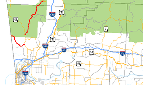
Arkansas Highway 220 is a designation for two state highways in west Arkansas. The southern segment of 7.89 miles (12.70 km) runs from Oklahoma State Highway 101 near Uniontown to AR 59.[1][2] A northern segment of 17.04 miles (27.42 km) runs from AR 59 north to AR 170 in Devil's Den State Park.[3] The route is not paved within Devil's Den State Park, and was the only Arkansas state highway that remains unpaved until a January 2016 announcement that paving would begin.[4] As of summer 2018, the entire route is now fully paved.
| ||||
|---|---|---|---|---|
 | ||||
| Route information | ||||
| Maintained by AHTD | ||||
| Southern segment | ||||
| Length | 7.89 mi[1] (12.70 km) | |||
| West end | ||||
| East end | ||||
| Northern segment | ||||
| Length | 17.04 mi[1] (27.42 km) | |||
| South end | ||||
| North end | ||||
| Location | ||||
| Counties | Crawford, Washington | |||
| Highway system | ||||
| ||||

Route description
AR 220 begins at SH 101 at the Oklahoma state line and runs as the Uniontown Highway to meet AR 59 south of Cedarville.
The route begins again 4 miles (6.4 km) north, when the route turns northeast, ending at AR 170 in Devil's Den State Park.
Major intersections
Southern segment
The entire route is in Crawford County.
| Location | mi[2] | km | Destinations | Notes | |
|---|---|---|---|---|---|
| Uniontown | 0.0 | 0.0 | |||
| Dripping Springs | 7.9 | 12.7 | |||
| 1.000 mi = 1.609 km; 1.000 km = 0.621 mi | |||||
Northern segment
| County | Location | mi[2][3] | km | Destinations | Notes |
|---|---|---|---|---|---|
| Crawford | Cedarville | 0.0 | 0.0 | ||
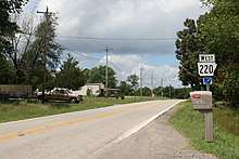
| Ozark National Forest | 9.8 | 15.8 | Pavement ends; route continues on unpaved road | ||
| Washington | Devil's Den State Park | 17.0 | 27.4 | ||
| 1.000 mi = 1.609 km; 1.000 km = 0.621 mi | |||||
See also
References
- "[Arkansas] State Highways 2009 (Database)." April 2010. AHTD: Planning and Research Division. Database. Archived 2011-07-07 at the Wayback Machine Retrieved April 24, 2011.
- General Highway Map - Crawford County, Arkansas (PDF) (Map) (1/3/11 ed.). Arkansas State Highway and Transportation Department. Retrieved April 24, 2011.
- General Highway Map - Washington County, Arkansas (PDF) (Map) (10/3/08 ed.). Arkansas State Highway and Transportation Department. Retrieved April 24, 2011.
- Bowden, Bill (January 25, 2016). "Last gravel highway in state, near Devil's Den, to be paved". Arkansas Online. Retrieved 26 January 2016.
External links
![]()