Angang-eup
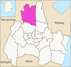
Angang-eup is an eup or a town and is the second-largest subdivision of Gyeongju City. Its 139 square kilometers are home to about 33,300 people, and is served by six elementary schools and two joint middle-high schools.[2] Situated next to Gangdong-myeon in the city's northern tip, it is a significant town in its own right. Angang Station is a regular stop on the Donghae Nambu Line. The town center lies on the Hyeongsan River, near where it meets the small Chilpyeongcheon stream. Important local products include rice, apples, and grapes.[1]
Angang-eup | |
|---|---|
eup | |
| Korean transcription(s) | |
| • Hangul | 안강읍 |
| • Hanja | 安康邑 |
| • Revised Romanization | Angang-eup |
| • McCune–Reischauer | Ankang-ŭp |
 | |
 Angang-eup | |
| Coordinates: 35.990°N 129.227°E | |
| Country | South Korea |
| Administrative divisions | 45 administrative ri (15 legal ri), 362 ban |
| Government | |
| • Type | Gyeongju City |
| Area | |
| • Total | 139.08 km2 (53.70 sq mi) |
| Population (2008)[1] | |
| • Total | 33,333 |
| • Density | 240/km2 (600/sq mi) |
| Dialect | Gyeongsang dialect |
Administrative divisions
- Gapsan-ri (갑산리)
- Ganggyo-ri (강교리)
- Geomdan-ri (검단리)
- Geungye-ri (근계리)
- Nodang-ri (노당리)
- Daedong-ri (대동리)
- Duryu-ri (두류리)
- Sabang-ri (사방리)
- Sandae-ri (산대리)
- Angang-ri (안강리)
- Yangwol-ri (양월리)
- Oksan-ri (옥산리)
- Uktong-ri (육통리)
- Cheongnyeong-ri (청령리)
- Hagok-ri (하곡리)
References
- "안강읍 Angang-eup 安康邑" (in Korean). Doosan Encyclopedia. Retrieved 2009-08-17.
- 교육기관 [Educational institution] (in Korean). Gyeongju City. Retrieved 2009-08-17.
External links
- (in Korean) The official site of Gampo-eup
4 eup, 8 myeon, 11 dong | ||
| Eup (town) |  | |
| Myeon (township) | ||
| Dong (neighborhood) | ||
| See also | ||
Website: www.gyeongju.go.kr | ||
This article is issued from Wikipedia. The text is licensed under Creative Commons - Attribution - Sharealike. Additional terms may apply for the media files.