Alabama State Route 289
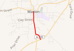
State Route 289 (SR 289) is a 1.202-mile-long (1.934 km) route that serves as a connection between both SR 5/183 and SR 14 within Marion in Perry County. It is known as Washington Street and Fikes Ferry Access for its entire length.
| ||||
|---|---|---|---|---|
| ||||
| Route information | ||||
| Maintained by ALDOT | ||||
| Length | 1.202 mi[1] (1.934 km) | |||
| Major junctions | ||||
| South end | ||||
| North end | ||||
| Location | ||||
| Counties | Perry | |||
| Highway system | ||||
| ||||

Route description
The southern terminus of SR 289 is located at its junction with SR 5 and SR 183 in southern Marion.[2] The route then takes a generally northward track along Fikes Ferry Access before curving to the west and coming to an intersection with Washington Street, where it turns north again to its northern terminus at SR 14 in the central business district of Marion.[3]
Major intersections
The entire route is in Marion, Perry County.
| mi[1] | km | Destinations | Notes | ||
|---|---|---|---|---|---|
| 0.000 | 0.000 | Southern terminus | |||
| 1.202 | 1.934 | Northern terminus | |||
| 1.000 mi = 1.609 km; 1.000 km = 0.621 mi | |||||
References
- Milepost Map of Perry County (PDF) (Map). Cartography by ALDOT Bureau of Transportation Planning, Survey & Mapping Division. Alabama Department of Transportation. 1999. Archived from the original (PDF) on 2008-06-25.
- Google (April 30, 2010). "SR-289 southern terminus" (Map). Google Maps. Google. Retrieved April 30, 2010.
- Google (April 30, 2010). "SR-289 northern terminus" (Map). Google Maps. Google. Retrieved April 30, 2010.
External links
This article is issued from Wikipedia. The text is licensed under Creative Commons - Attribution - Sharealike. Additional terms may apply for the media files.