Alabama State Route 129
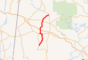
State Route 129 (SR 129) is a 41.2-mile-long (66.3 km) state highway in Fayette and Marion counties in the northwestern part of the U.S. state of Alabama. The southern terminus of the highway is at U.S. Route 43 (US 43) and SR 171 north of Fayette. The northern terminus of the highway is at an intersection with SR 13 in Haleyville.
| ||||
|---|---|---|---|---|
| ||||
| Route information | ||||
| Maintained by ALDOT | ||||
| Length | 41.2 mi[1] (66.3 km) | |||
| Major junctions | ||||
| South end | ||||
| North end | ||||
| Highway system | ||||
| ||||

Route description
.jpg)
SR 129 begins at an intersection with US 43/SR 171 north of Fayette. After only 1.3 miles (2.1 km), SR 129 intersects SR 102. While going through the town of Glen Allen, SR 129 intersects the southern terminus of SR 233. Then, SR 129 enters Marion County. Before reaching Winfield, SR 129 has a concurrency with SR 118 for 1.4 miles (2.3 km). While heading north toward Brilliant, SR 129 has an interchange with Interstate 22 (I-22)/US 78/SR 4 then heads north to Brilliant through wooded areas. Before reaching its northern terminus, SR 129 intersects US 278 (internally designated as SR 74) and SR 241. SR 129 reaches its northern terminus, at an intersection with SR 13 in Haleyville.[2]
Major intersections
| County | Location | mi[1] | km | Destinations | Notes |
|---|---|---|---|---|---|
| Fayette | Fayette | 0.0 | 0.0 | Southern terminus | |
| | 1.3 | 2.1 | |||
| Marion | Glen Allen | 13.8 | 22.2 | Southern terminus of SR 233 | |
| Winfield | 15.3 | 24.6 | Southern end of SR 118 concurrency | ||
| 16.7 | 26.9 | Northern end of SR 118 concurrency | |||
| 20.9 | 33.6 | I-22/US 78/SR 4 exit 30 | |||
| Brilliant | 22.9 | 36.9 | Eastern terminus of SR 44 | ||
| | 31.4 | 50.5 | |||
| Haleyville | 41.2 | 66.3 | Northern terminus | ||
1.000 mi = 1.609 km; 1.000 km = 0.621 mi
| |||||
See also


References
- Alabama Department of Transportation. "Milepost Maps". Archived from the original on July 27, 2011. Retrieved April 2, 2011.
- Google (December 14, 2019). "Alabama State Route 129" (Map). Google Maps. Google. Retrieved December 14, 2019.
External links
