Al-Bustan, Oman
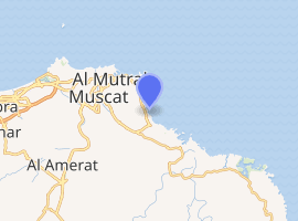
Al Bustān (Arabic: البستان) is a village in Muscat, in eastern Oman.[2] (23°34'15.02"; 58°36'32.70"E, 8 m altitude). This cemetery was used during the Samad Late Iron Age.
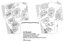
Excavated Late Iron Age graves at al-Bustan, Oman. Left: excavated, right: prior to excavation.
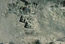
Aerial view of excavated Late Iron Age graves at al-Bustan.
Al Bustān البستان | |
|---|---|
Village | |
| Country | |
| Governorate | Muscat Governorate |
| Time zone | UTC+4 (Oman Standard Time) |
Archaeological site in Oman.
 Oman | |
| |
| Location | Al Bustan Oman |
|---|---|
| Coordinates | 23°35′03.8″N 58°36′28.2″E |
| Foundation | concrete base |
| Construction | metal post |
| Tower shape | cylindrical post |
| Tower height | 7 metres (23 ft) |
| Focal height | 9 metres (30 ft) |
| Range | 3 nautical miles (5.6 km; 3.5 mi) |
| Characteristic | Fl (2) R 5s. |
| Admiralty number | D7318.4 |
| NGA number | 28610 [1] |
Overview
In 1991 the Ministry of National Heritage and Culture became aware of this cemetery, close to the Al-Bustan Palace.
In the same year a team from the German Mining Museum in Bochum excavated seven graves.
Sources
- Paul Yule, Die Gräberfelder in Samad al-Shan (Sultanat Oman): Materialien zu einer Kulturgeschichte (2001), Taf. 482-500 ISBN 3-89646-634-8.
- Paul Yule, Cross-roads – Early and Late Iron Age South-eastern Arabia, Abhandlungen Deutsche Orient-Gesellschaft, vol. 30, Wiesbaden 2014, 89 ISBN 978-3-447-10127-1
- Paul A. Yule, Valourising the Samad Late Iron Age, Arabian Archaeology and Epigraphy 27/1, 2016, 31‒71.
See also
References
- NGA List of Lights – Pub.112 Retrieved 13 October 2016
- National Geospatial-Intelligence Agency. Geonames database entry. (search) Accessed 2011-05-12.
This article is issued from Wikipedia. The text is licensed under Creative Commons - Attribution - Sharealike. Additional terms may apply for the media files.