Ak Chut Vaya, Arizona
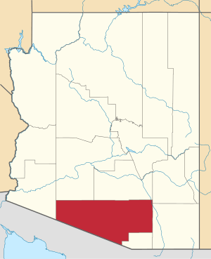
Ak Chut Vaya is a populated place located in Pima County.[2] It has an estimated elevation of 2,434 feet (742 m) above sea level.
Ak Chut Vaya, Arizona | |
|---|---|
Populated place | |
 Ak Chut Vaya, Arizona Location of Ak Chut Vaya in Arizona | |
| Coordinates: 31°37′50″N 111°48′34″W | |
| Country | United States |
| State | Arizona |
| County | Pima |
| Elevation | 2,434 ft (742 m) |
| Time zone | UTC-7 (Mountain (MST)) |
| • Summer (DST) | UTC-7 (MST) |
| ZIP codes | 85634 |
| Area code(s) | 520 |
| FIPS code | 04-01100 |
| GNIS feature ID | 24296 |
The settlement is located on the Tohono Oʼodham Indian Reservation.[3] The Tohono Oʼodham name "Ak Chut Vaya" translates to "arroyo well" in English.[3]
References
- "Feature Detail Report for: Ak Chut Vaya". Geographic Names Information System. United States Geological Survey.
- "Ak Chut Vaya (in Pima County, AZ) Populated Place Profile". AZ Hometown Locator. Retrieved December 13, 2015.
- Bright, William (2013). Native American Placenames of the Southwest: A Handbook for Travelers. University of Oklahoma Press. p. 5.
This article is issued from Wikipedia. The text is licensed under Creative Commons - Attribution - Sharealike. Additional terms may apply for the media files.