Aguadilla barrio-pueblo
Aguadilla barrio-pueblo is a barrio and the administrative center (seat) of Aguadilla, a municipality of Puerto Rico. Its population in 2010 was 3,627.[1][3][4][5]
Aguadilla barrio-pueblo Barrio Pueblo Aguadilla | |
|---|---|
Municipality Seat[1] | |
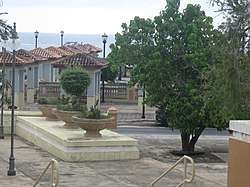 Central Plaza of Aguadilla with ocean view. | |
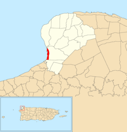 | |
 Aguadilla barrio-pueblo Aguadilla barrio-pueblo, Aguadilla, Puerto Rico  Aguadilla barrio-pueblo Aguadilla barrio-pueblo (Caribbean) | |
| Coordinates: 18°25′47″N 67°09′20″W[2] | |
| Commonwealth | |
| Municipality | |
| Area | |
| • Total | 0.74 sq mi (1.9 km2) |
| • Land | 0.37 sq mi (1.0 km2) |
| • Water | 0.37 sq mi (1.0 km2) |
| Population (2010) | |
| • Total | 3,627 |
| • Density | 9,802.7/sq mi (3,784.8/km2) |
| Source: 2010 Census | |
| Time zone | UTC−4 (AST) |
As was customary in Spain, in Puerto Rico, the municipality has a barrio called pueblo which contains a central plaza, the municipal buildings (city hall), and a Catholic church. Fiestas patronales (patron saint festivals) are held in the central plaza every year.[6][7]
The central plaza history
The central plaza, or square, is a place for official and unofficial recreational events and a place where people can gather and socialize from dusk to dawn. The Laws of the Indies, Spanish law, which regulated life in Puerto Rico in the early 19th century, stated the plaza's purpose was for "the parties" (celebrations, festivities) (Spanish: a propósito para las fiestas), and that the square should be proportionally large enough for the number of neighbors (Spanish: grandeza proporcionada al número de vecinos). These Spanish regulations also stated that the streets nearby should be comfortable portals for passersby, protecting them from the elements: sun and rain.[6]
Sectors
Barrios (which are like minor civil divisions)[5] in turn are further subdivided into smaller local populated place areas/units called sectores (sectors in English). The types of sectores may vary, from normally sector to urbanización to reparto to barriada to residencial, among others.[8][9][10][11][12]
The following sectors are in Barrio Pueblo (Norte):[13]
Avenida Los Robles, Calle Barbosa, Calle Ceiba, Calle Duda, Calle Fuerte, Calle Reguero, Calle Stahl, Callejón del Fuerte, Cerro Juan Vega, Condominio Cuesta Vieja, El Chapey, El Perú, Joya Las Marinas, Residencial Cuesta Vieja, Residencial Puesta del Sol, Sector Cerro Los Condenados (Cuesta Vieja), Sector Cerro Reguero, Sector Cuesta Nueva, Sector Cuesta Vieja, Sector La Vía (Norte), Sector Llanos Jiménez, Sector Luquillo, and Sector Tamarindo.
The following sectors are in Barrio Pueblo (Sur y Centro):[13]
Avenida San Carlos, Barriada Visbal, Barrio Higuey, Barrio Iglesias, Calle Mercado, Calle Mercedes Moreno, Calle Progreso, Cerro Cabrera, Cerro Calero, Cerro Echevarría, Cerro Gonzalo, Condominio Torres del Sol, Condominio Villa Mar, Residencial Villamar, Salsipuedes, Santa Bárbara, Sector Campo Alegre, Sector Cerro Las Ánimas, Sector Gregorio Vélez Vaz, Sector Joyas San Carlos, and Sector La Vía (Sur).
Gallery
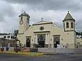 Catholic church in Aguadilla Central plaza
 Aguadilla Central plaza
 Colorful buildings adjacent to Aguadilla Central plaza
 Street art adjacent to Aguadilla Central plaza
 Statue of José de Diego in Aguadilla Central plaza
 Police headquarters in Aguadilla barrio-pueblo
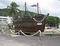 Wooden boat on Aguadilla waterfront road
 Aguadilla police
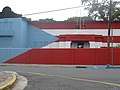 Flag painted on building in Aguadilla barrio-pueblo
 Aguadilla nickname on side of Aguadilla Electronic Library
References
- Puerto Rico:2010:population and housing unit counts.pdf (PDF). U.S. Dept. of Commerce, Economics and Statistics Administration, U.S. Census Bureau. 2010. Archived (PDF) from the original on 2017-02-20. Retrieved 2019-01-09.
- "US Gazetteer 2019". US Census. US Government. Archived from the original on 2020-01-16. Retrieved 2020-06-24.
- Picó, Rafael; Buitrago de Santiago, Zayda; Berrios, Hector H. Nueva geografía de Puerto Rico: física, económica, y social, por Rafael Picó. Con la colaboración de Zayda Buitrago de Santiago y Héctor H. Berrios. San Juan Editorial Universitaria, Universidad de Puerto Rico,1969. Archived from the original on 2018-12-26. Retrieved 2019-01-09.
- Gwillim Law (20 May 2015). Administrative Subdivisions of Countries: A Comprehensive World Reference, 1900 through 1998. McFarland. p. 300. ISBN 978-1-4766-0447-3. Retrieved 25 December 2018.
- "US Census Barrio-Pueblo definition". factfinder.com. US Census. Archived from the original on 13 May 2017. Retrieved 5 January 2019.
- Santullano, Luis A. (10 March 2019). Mirada al Caribe. 54. Colegio de Mexico. pp. 75–78. doi:10.2307/j.ctvbcd2vs.12. JSTOR j.ctvbcd2vs.12.
- Pariser, Harry S. (2003). Explore Puerto Rico, Fifth Edition. San Francisco: Manatee Press. pp. 52–55. Retrieved 10 February 2019.
- Mari Mut, José A. (28 August 2013). "Los pueblos de Puerto Rico y las iglesias de sus plazas" (in Spanish). Retrieved 19 June 2020 – via archive.org.
- "Agencia: Oficina del Coordinador General para el Financiamiento Socioeconómico y la Autogestión (Proposed 2016 Budget)". Puerto Rico Budgets (in Spanish). Archived from the original on 28 June 2019. Retrieved 28 June 2019.
- Rivera Quintero, Marcia (2014), El vuelo de la esperanza : Proyecto de las Comunidades Especiales Puerto Rico, 1997-2004 (Primera edición ed.), San Juan, Puerto Rico Fundación Sila M. Calderón, ISBN 978-0-9820806-1-0
- "Leyes del 2001". Lex Juris Puerto Rico (in Spanish). Archived from the original on 14 September 2018. Retrieved 24 June 2019.
- "Comunidades Especiales de Puerto Rico" (in Spanish). 8 August 2011. Archived from the original on 24 June 2019. Retrieved 24 June 2019.
- "PRECINTO ELECTORAL AGUADILLA 035" (PDF). Comisión Estatal de Elecciones (in Spanish). PR Government. 30 January 2019. Retrieved 21 June 2020.