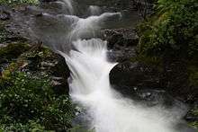
Afon Dulas
The Afon Dulas (also referred to as the North Dulas) is a river forming the border between Merionethshire/Gwynedd and Montgomeryshire/Powys in Wales.
Route
It rises from a source in the hills above Aberllefenni and passes through Corris, Esgairgeiliog and Pantperthog before joining the Afon Dyfi at Ffridd Gate near Machynlleth.[1]
History
The Dulas is recorded as an important land boundary in 1200, in a document written in 1428. This document describes the land owned by Einion ap Seisyllt, in the time of Llywelyn the Great, as "tota terra inter aquas de Dyfi et Delwas" (Latin, meaning: all the land between the rivers Dyfi and Dulas).[2]
Roads and Railways in the Dulas valley
- The A487 trunk road follows the valley from Ffridd Gate to Corris
- The Roman road Sarn Helen probably followed the valley from Aberllefenni to Ffridd Gate
- The Corris Railway ran through the valley from Aberllefenni to Ffridd Gate
Tributaries
- Nant y Darren
- Nant Cwm Cadian near Pantperthog[3]
- Afon Glesyrch at Esgairgeiliog
- Nant y Goedwig south of Maespoeth Junction
- Afon Deri (formerly known as Afon Corris) at Corris
- Afon Llefenni at Aberllefenni
- Nant Llwydiarth at Pont Cymerau, Aberllefenni[3]
- Nant Ceiswyn at Pont Cymerau, Aberllefenni[4]
South Dulas
Another river also called the Afon Dulas joins the Dyfi from the south, upstream of its confluence with the North Dulas. Locally this is referred to as the South Dulas. It rises in Glaslyn, below the slopes of Foel Fadian, and passes the hamlet of Forge and Plas Dolguog before joining the Dyfi.
References
- W. T. Pratt; D. G. Woodhall; Malcolm Fletcher Howells; M. J. Leng (1995). Geology of the Country Around Cadair Idris. H.M. Stationery Office. ISBN 978-0-11-884509-0.
- Owen, George (1892). "The Description of Pembrokshire". Cymmrodorion record series. London: Society of Cymmrodorion. 1: 221.
- Cylchgrawn Cymdeithas Hanes a Chofnodion Sir Feirionydd. The Society. 1957.
- Edwyn Jervoise; Society for the Protection of Ancient Buildings (London, England) (1936). The ancient bridges of Wales and western England. The Architectural press.