Ertholmene
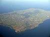
Ertholmene (formerly spelled Ærtholmene) is a small archipelago in Denmark. The largest island is Christiansø, and its name often refers to the entire archipelago.[2] Ertholmene is situated 18 kilometres (11 mi) northeast of Gudhjem, Bornholm, and contains Denmark's easternmost point.[2] Two of its islands, Christiansø and Frederiksø, are inhabited,[2] and their combined permanent population (as of 2020) is 84.[3] The archipelago have a total area of 39 hectares. Its name is derived from the Danish for "pea islands".
| Fæstningen Christiansø | |
|---|---|
| Northeast of Bornholm, Denmark | |
 | |
| Type | Naval fortress |
| Site information | |
| Controlled by | Denmark |
| Site history | |
| Built | 1684 |
| In use | 1684-1855 (1863) |
| Battles/wars | Gunboat War |
| Designations | |
|---|---|
| Official name | Ertholmene |
| Designated | 9 February 1977 |
| Reference no. | 165[1] |
Together with Bornholm it is part of Landsdel Bornholm. Ertholmene makes up the Parish of Christiansø in the Church of Denmark and is served by Christiansø Church. On 1 January 2017 out of 78 inhabitants in total there were 69 members of the Church of Denmark (88.46% of the population). Ertholmene has never been part of a municipality, county, or region. The islands are administered by the Ministry of Defence.
Islands
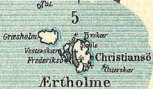
Ertholmene consists of three main islands, Christiansø, Frederiksø and Græsholm, plus a number of rocks and skerries.
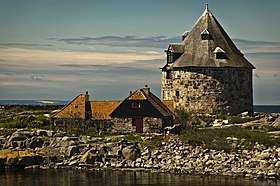
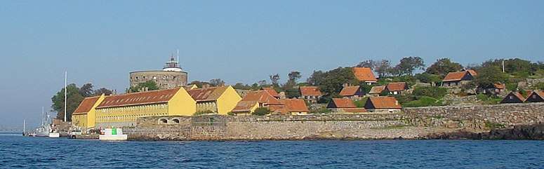
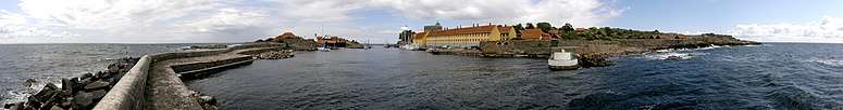
- Christiansø, named after King Christian V, is with an area of 22.3 hectares the largest island in the archipelago. It is home to Christiansø Church and Christiansø Lighthouse. The highest point of Ertholmene is Møllebakken on Christiansø, 22 m above the sea level.
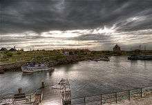
- Frederiksø, named after King Frederick IV, have an area of 4 hectares. It is the only other inhabited island besides Christiansø. It is located just west of Christiansø, and connected to it via a 30 m swing bridge for pedestrians. The sound between Christiansø and Frederiksø is a well-sheltered natural harbour. Frederiksø is home to Christiansø Museum, which is situated inside Lille Tårn (Little Tower).
- Græsholm, have an area of 11 hectares. It is uninhabited and serves as a bird reserve.
- Østerskær is skerry located 300 m east of Christiansø. It is the easternmost point of Denmark, at 15° 11' 55" eastern longitude.
- Tat is a skerry located 1.1 km northwest of Christiansø and Frederiksø. It is 100 m long and 75 m wide, and surrounded by a number of smaller skerries. It contains a lighthouse, and serves as a bird reserve.
History
Fishermen from Bornholm have used Ertholmene for temporary shelter since the Middle Ages. The first permanent settlement was the result of the Danish-Swedish conflicts in the late 17th century. As Denmark needed a naval base in the central Baltic Sea, a fort was built on Christiansø and Frederiksø in 1684 which served as an outpost for the Danish Navy until 1855. Christiansø Church originally served the garrison.[4] The population peaked at the census in 1810 which showed 829 inhabitants. They were soldiers and were there because of the Gunboat War.
Many of the historical buildings now serve as living quarters for the local population, and some are rented, year after year, to regular summer residents. The islands' external appearance has changed very little in over 300 years. Girdled by thick granite walls with old cannons pointed seaward, Christiansø is a picturesque tourist spot seemingly frozen in time. A former part of the fort, Store Tårn has housed the Christiansø Lighthouse for the past 200 years,[5] and a small round tower on Frederiksø, Lille Tårn, serves as a museum.
Administrative status
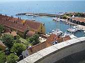
The islands form an unincorporated area that does not belong to either a municipality or a region. Instead they are state property governed by an administrator, appointed by the Danish ministry of defence, with the responsibility being the tasks normally performed by municipalities and other public sector civil services. The major sources of income are fishery and tourism. There are 80,000 tourists per year, mostly day visitors arriving via Bornholm. Ertholmene is also a popular destination for yachts.
Taxation
The islanders, who do not pay municipal taxes of any kind and were never part of a municipality, were exempt from the central government "Health Contribution" tax (Sundhedsbidrag) which stood at 8% when it was introduced on 1 January 2007 with Kommunalreformen ("The Municipal Reform" of 2007), because it was thought that the relatively isolated islets would otherwise be abandoned. This tax replaced the county tax, which the islanders were also exempt from paying, not being part of a county. From 1 January 2019 this tax has been abolished, while income taxes in the lowest bracket have been raised simultaneously instead with this tax being phased out. From 2012, the tax was lowered by one percentage point per year.[6][7]
Gallery
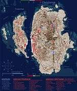 Buildings and water on Christiansø and Frederiksø
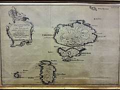 Ertholmene, 1756
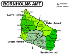 Bornholm and Christiansø hundreds and 5 municipalities (1970-2002) in green color and 21 municipalities until 31 March 1970
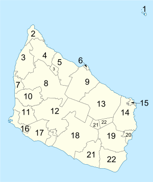 Parishes numbered. Ertholmene is the parish mentioned with the number "1" in the upper right hand corner.

Notes
- "Ertholmene". Ramsar Sites Information Service. Retrieved 25 April 2018.
- Jørgensen, Jens Riis (7 December 2016). "Ertholmene". Den Store Danske. Gyldendal. Retrieved 24 April 2020.
- "Population 1. January by islands". StatBank Denmark. Statistics Denmark. Retrieved 24 April 2020.
- Otto Norn, C. G. Schultz, Erik Skov, "Christiansø Kirke": Bornholms Nørre Herred, Danmarks Kirker, Bornholm, Nationalmuseet, Gad, 1954, pp. 576–583. (in Danish) Retrieved 2 October 2012
- Anker E. Kofoed: Christiansøs Historie, Christiansøs Museum, 1984. (in Danish)
- Bornholm.nu » Christiansø » Ingen sundhedsskat på Chr.ø
- Bornholm.nu » Christiansø » Bornholm kan få Christiansø
External links
![]()
 | |
| Towns & villages | |
| Localities | |
| Churches | |
| Culture | |
| Fortifications | |
| Lighthouses | |
| Windmills | |
| Beauty spots |
|
| Transport | |
| Attractions |
|