Wayanad District
Wayanad is a region of Kerala state in India. It is a forest district with a small population engaged in agricultural activities. The whole district is part of the Western Ghats range of hills.

Cities

Other destinations
- Begur Wildlife Sanctuary — has a huge variety of animals such as elephants, deer, tigers, boars, and leopards as well as a diverse population of birds
- 🌍 Wayanad Wildlife Sanctuary — at Muthanga, near Sultan Battery, home to large population of elephants, and other wildlife, including some tigers
Understand
Wayanad is the best place in Kerala for hill tourism. Most parts of the district are protected forest and the remaining area is lush green cultivation with a relatively thinner population. Urbanization has reached only 4% of the district. The altitude reaches up to 2,100 ft in some parts of Wayanad.
Talk
Malayalam is the common language here. English is understood by half the people. They can also reply in English but there is a mysterious 'shyness' among the locals. Wayanad is very close to Karnataka but Kannada language is not understood.
Get in

Wayanad District has no railway lines. Buses are available from Kozhikode and Mysore. Access from Kerala is difficult because of the mountain passes or 'ghat roads'. Access from Mysore and Madikeri is easier as no Ghat Roads are involved. The nearest airports are at Kondotty and Bangalore. Mysore airport is functional without any flights ! Night traffic is banned towards Mysore, Bangalore side. However, night traffic is allowed through Mananthavady.
Main Routes
- Bangalore-Mysore-Gundalpet-MuthangaForest-Sultanbathery.256 km (good roads with too many humps inside the forest.. You can expect six humps every six kilometer).
- Sultan Bathery-Kolagappara-Kakkavayal-Muttil-Kalpetta-Chundale-Vythiri. 35 km (Wayanad Main Road)
- Ooty-Gudalur-Devarshola-Sultan Bathery. 92 km
- Kozhikode-Thamarassery-Vythiri-Kalpetta. 70 km.
- Kannur-Iritty-Kottiyoor-Boystown-Mananthavady.94 km(Very steep and risky climb)
- Thalassery-Kuthuparamba-Nedumpoyil-Periya-Boystown-Mananthavady. 82 km
- Vadakara-Kuttiady-Niravilpuzha-Kanhirangad-Kallody-Mananthvady. 67 km
- Vadakara-Kuttiady-Kanhirangad-Vellamunda-Tharuvana-Padincharethara- Kalpetta. 88 km
- Malappuram-Nilambur-Vazhikkadavu-Gudalur-Sultanbathery. 120 km
- Mananthavady-Kutta-Gonikupa-Virajpet-Madikeri.115 km. Night traffic is allowed only in this route.
- Mysore-HDKote-Bavali-Mananthavady.112 km (No hump issue, night traffic is not allowed).
- Mananthavady-Nalammile-Panamaram-Kambalakkad-Kalpetta. 37 km
Get around
- Autorikshaws charge ₹15.00 per km
- Buses charge only ₹.00 for three km.
- Walking is impossible as numerous noisy motorcycles pester you even in village roads.
KSRTC buses are available to longer distances.
- bus stations in Wayanad tend to disappoint you with the shortage of buses and no facility for sitting. But the KSRTC bus station at Sultan Battery has good connections to places inside Wayanad or outside Wayanad.
- Cars can be rented for as cheap as ₹1800 a day with a driver. The rate is even cheaper if you rent without a driver.
You can drink coffee at this bus station, but any snacks purchased will be immediately snatched by the ubiquitous monkey groups.
See

The attractions in this region can be broadly categorized into three based on proximity. A 3-4 day tour allows covering all or most of these attractions. For further info, refer details on each town.
Kalpetta area
- Banasura Sagar Dam
- Chembra Hills.
- Karappuzha Dam
- Meenmutty Falls
- Pookode Lake
- Meppadi Hills
Sultan Battery area
- Jain Temple
- Tholpetty Sanctuary
- Agricultural University
- Edakkal Caves
- Wayanad (Muthanga) wildlife sanctuary

Mananthavady area
- Kuruva Islands
- Latin Church
- Pakshipathalam
- Pazhassi Raja Museum
- Thirunelli Temple
- Kutta Forest
- Nagarhole National Park
- Pulpally - Bathery forest road
Do
- Hiking in the hills
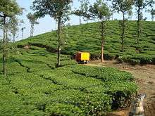
- Walking in the tea estates
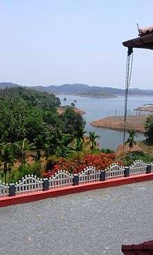
- Enjoying lakes and rivers
- Watching the Wildlife
- Walking in the serene villages
Eat

Kerala food is available in restaurants. European food is available in resorts and home stays only.
Bamboo rice (called Mulayari by locals) can be found in Wayanad. These are seeds of the Bamboo plant, richer in protein than rice and wheat, but tasting like rice. Bamboo rice payasam stalls can be spotted near Edakkal caves walkway. Bamboo is said to yield seeds after a long span, so it is said that harvesting bamboo rice is a 'once-in-a-lifetime' experience.
Home-made chocolates and local Wayanad tea and coffee are also sold in many places. Shops near Edakkal caves offer many options such as spiced versions.
Drink
Beer and wine are easily available. Stronger drinks come under a recent prohibition. Kambalakkad though does not have beer- you'd have to get it from Kalpetta or a neighboring town.
Sleep
Lodges in Wayanad have the cheapest tariff compared to other parts of Kerala. Resorts and home stays are expensive options. Accommodation below ₹500 per night are available in Kalpetta and Sultan Bathery towns. Mananthavady is even cheaper. Resorts and homestays charge between ₹2,000 and ₹4,000 per night. They can also arrange tours and trips.
Stay safe
- The eastern hills of Kerala are vulnerable to attacks from an Indian communist group called Maoists. Recently they attacked the ticket counter of Silent Valley National Park, Mukkali. As the Maoists are armed and dangerous, be careful when you trek in lonely areas.
- Leeches are common in the hills. Carry some table salt to dislodge the leeches.
- Monkeys can be a nuisance, especially at places like Lakkidi viewpoint. Be careful and keep your car windows closed, and food items hidden.