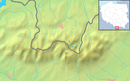
Tatra National Park (Poland)
The Tatra Mountains are a mountain range which forms a natural border between Poland and Slovakia, and are the highest mountain range in the Carpathian Mountains.
In both countries, the english translation of their part is "Tatra National Park". However, in Polish, it's Tatrzański Park Narodowy - while the Slovakian side the name is Tatranský Národný Park.
Cities

Other destinations
- 🌍 Western Tatras - the western part of the park
Understand
Talk
Tatra mountains span across border between Poland and Slovakia, so most people you may meet there will speak in languages of these countries, but communicative English is also very common. Staff at mountain refuges should be able to communicate in English too.
Get in
Get around
By foot
Most interesting part of these mountains is under national park protection, so if you want to see it, you will have to walk a lot. Mountain range has many trails for both experienced and novice hikers, so navigation is not a problem, but checking difficulty of trail before setting of is mandatory if you want to avoid unpleasant surprises. Another thing worth noticing is that some harder trails are one-way only, and can be pretty dangerous under bad weather conditions.
By bus
On the Polish side, the bus is the best way to get around outside the national park, because buses are cheap (3zł ~ €0.7), arrive and depart very often, and sometimes it is possible to negotiate the route.
By train
There is a railway parallel to mountain range in Slovakia, so in addition to being convenient means of transport it provides astonishing views on High Tatras. In the winter it is also good for getting from one ski resort to another.
See
Do
Eat
Drink
Sleep
Lodging
- 🌍 PTTK Shelter Murowaniec, ☎ +48 18 201 26 33. Lodge in the mountains. In the rooms with 5 people and more, a fee for linen (10 zł/person) is required. 45-85 zł per person depending on room size.
- 🌍 Shelter Kalatówki (Schronisko Kalatówki), ☎ +48 18 206 36 44, e-mail: recepcja@kalatowki.pl. 55-125 zł per person depending on room size and period of traveling.
- 🌍 Shelter Hala Kondratowa (Schronisko Hala Kondratowa), ☎ +48 18 201 91 14, e-mail: schronisko@halakondratowa.pl. Shelter with two rooms for 6 and one big room for 8 people. 37 zł per person.