Taroko Gorge
Taroko Gorge (太魯閣: Tàilǔgé) is an impressive 19-km-long canyon near Taiwan's east coast. The area of the gorge is also identified as Taroko Gorge National Park (太魯閣國家公園; Tàilǔgé gúojiā gōngyuán).
Understand
The Taroko Gorge is composed mainly metomorphic rocks, such as marble, gneiss, and schist. The name, Taroko, means the "magnificent and splendid" in the language of Truku, the aboriginal tribe residing in the area.
.jpg)
History
When Taroko National Park was established on November 28, 1986, it was of special significance for the environmental protection movement in Taiwan: it showed that both the public and the government agencies had realized despite the nation's four decades of extraordinary economic success, serious damage was being done to its natural resources.
Landscape
The most phenomenal aspect of the park is the amazing relief. In a single afternoon you can travel from rugged coastal cliffs through a maze of subtropical forested canyons to high elevation sub-alpine coniferous forests. In about 60 km the landscape rises from sea level to some of the tallest peaks in Taiwan at over 3400 m. That's steep!
The force behind the steep valleys and narrow canyons is a (geologically speaking) relatively fast rate of uplift combined with ample water. Over the last 70 million years, these two forces collaborated to form the world's deepest marble canyon. The slot canyons here are remarkable with narrows sections 300 m high and only a dozen meters apart, reminiscent of the Virgin River in Zion National Park in Utah, USA. Ignore the fact that Zion is in the desert, and made of sandstone and Taroko is subtropical and comprised of marble, and these two gorges have a lot in common.
Flora and fauna
The park has 144 species of birds, 10% of which are indigenous to Taiwan. It also hosts over 30 large species of mammals, including deer, boar, and bear. 251 species of butterflies, 32 species of reptiles and 18 species of fish have been identified, but considering the rugged terrain of the park, this is probably only a fraction of the species that actually live in the park.
Climate
The climate is subtropical and generally mild. Rainfall is abundant year round so be prepared and be especially cautious about entering the gorge during typhoons or periods of extended heavy rain due to the danger of landslides and rockfall.
The weather in the gorge can often be surprisingly well with open and blue sky, even when it is raining in Hualien.
According the Taiwan Central Weather Bureau, average temperatures at low elevations in the park range from 14°C in January to 27°C in July. At higher elevation it is much cooler with winter temperatures at 2000 m being about 5.5°C in the winter and 17.5°C in the summer and at 3400 m at the top of Hehuan, temperatures average -3°C in January and 9°C in July.
Get in
The nearest major city is Hualien. Flights and trains are available from Taipei and most major cities.
By bus
- Shuttle bus from Hualien (Left when coming out of the Hualien TRA station, where also you can find the ticket office.), ☎ +886 38322065, +886 38320431, +886 38360634 (08:00-20:00). The buses leave from Hualien at 07:00 (wheel chair access), 08:30, 09:10, 10:00, 11:10 (wheel chair access), 12:00, 13:20, 14:10 and 15:10 (wheel chair access) daily - it's about 40 minutes to the Park HQ, 1:15 hr to Tianxiang, and the full loop about 2½ hours. Buses from Tianxiang to Hualien leave at 08:40 (wheel chair access), 10:00, 10:40, 11:40, 12:50 (wheel chair access), 14:10, 15:00, 15:50 and 17:00 (wheel chair access), and 30 min later from the Park HQ aka Taroko Visitor Center.. The bus stops at Qixintan Beach, Xincheng Railway Station, Taroko Archway, Taroko National Park HQ & Visitor Center (太管處), Changchun Shrine, Yanzikou (Swallow Grotto, 燕子口), Jiuqudong (Tunnel of Nine Turns, 九曲洞), Lushui (合流.綠水), Tianxiang (天祥) and then back along the a similar, but not absolutely identical route. But it stops also where hailed. Make sure you are standing on the right side of the road and hail at the bus if you wish to get on. It goes quite slow, so you will not feel your stomach that much. On the way back, do not catch the bus at the Taroko Visitor Center at the entrance of the gorge, otherwise it might be full in the evening. However, during the week this will seldom happen.
- Regular buses from Hualien. +886 38322065. Regular buses depart from the Hualien TRA station at 06:30 (to Luoshao), 08:40 (to Lishan), 10:50 (to Tianxiang) and 13:50 (to Tianxiang). All buses stop at Tzuchi Vihara, Xincheng Taroko Station (太魯閣火車站), Taroko Visitor Center (park entrance), Shakadang (砂卡礑) and Buluowan (布落灣). Although the distance is not large, buses should take at least 2 hours to Tianxiang, due to very frequent stops and reduced speed inside the gorge. The buses no. 1126, 1133 and 1141 can also be used with the 1- and 2-day shuttle bus passes. Otherwise, the price is about NT$170, with no change given. So, be sure to bring the exact amount. EasyCard can also be used.
The Visitor Center offers free maps of the area. They can also provide you with up-to-date information on which trails are closed, as the weather and earthquakes may make them unsafe.
By train
A journey by train from Taipei to Hualien takes 2 hr by express train (NT$440) and 3-4 hr by local trains. The trains are cheap, reliable and comfortable. Station names are announced in English and Chinese so you should have no problem identifying your stop. The closest train station to the park entrance is 🌍 'Sincheng' (Xincheng, 新城). From there, you can use the before mentioned shuttle or regular buses, or there is the choice of one way taxi rides for about NT$200 or a taxi day tour for about NT$2,000.
By taxi
A taxi from the Hualien train station to Tianxiang (town in Taroko National Park, where the Grand Formosa hotel is located) costs about NT$1200 and takes about 1 hour.
By scooter
You can rent a scooter near the train station in Hualien. It takes around 30 min to reach Taroko Gorge. However in some cases you may need a local drivers license to do so.
You can also rent a scooter by the Xincheng train station, which is closer to the park. The price quoted in April 2012 was NT$500 per day. An American or European drivers license (and possibly other countries as well) and a passport will suffice at this shop.
Fees and permits
Entry to the park is free but if you want to go to some of the wilderness or into areas designated as Eco-protection areas or restricted mountain areas, you will need an entry permit. Be sure to apply for the permits early (at least 1 week before) as some permits are limited by a small number per day. Refer to the official Taroko National Park information website for application procedures.
Get around
Note, many tunnels can also be traversed on foot, in case you want to get from one to another just nearby sight.
By bus
The shuttle bus and regular buses, see above.
Furthermore, there are numerous bus tours visiting the gorge every weekend. And, while the buses are comfortable and air-conditioned, the tours tend to have a tight itinerary (including, of course, the obligatory stop at some local gift shop), leaving little time for extended hiking. Tour buses leave from the Hualien visitor information center and cost about NT$988 per person for a whole day tour.
From Tianxiang, the regular buses depart to inside the gorge at 08:00 to LuoShao (洛韶) and 10:05 to LiShan (梨山). Starting from Tianxiang (169.5 km of highway 8; altitude: 480 m), the bus to Lishan runs through Wenshan (167 km, 575 m), Huitouwan (163.4 km, 750 m), Xibao (161.4 km, 915 m), Luoshao (洛韶, 154 km, 1,117 m), Xinbaiyang (143 km, 1,644 m), Ci'en (132.8 km, 1,995 m), Bilü Sacred Tree (128.3 km, 2,150 m), Guanyuan (117.3 km, 2,374 m), Dayuling (112.5 km, 2,565 m), Lishan (1,800 m). The bus to Lishan arrives there at 13:00, and departs from Lishan to Tianxiang at 15:00.
By car
Renting a car in Hualien is definitely an option, though be very cautious; the roads through the gorge are extremely narrow with numerous bends. In addition, there are pedestrians, scooters, cars and massive tour buses all vying for the tight space.
By scooter
The Gorge is not the best place for a first scooter experience. However, it's a fantastic place to ride for those with experience. Scooters are available to rent in Hualien. If you run low on fuel, the locals often stock a small supply that they'll part with for a miraculously uninflated price. There is also a gas station 50 km passed Taroko on the number 8 road (around km 118). The drive there climbs to an impressive 3 km altitude. Bring warmer clothes and rain gear. Also make sure to get a helmet with a rain visor.
You can rent a scooter from Pony near the train station in Hualien (around NT$400/day).
By bicycle
For the truly adventurous, cycling is a wonderful way to traverse the park. You can rent a bike in front of the entrance of the Taroko national park. It costs NT$250 for a day.
On foot
If you do not have any of the above you can see some parts of the national park by foot. The closest hiking trail to the park entrance is the Shakadang Trail, which departs from the road after the first tunnel approximately 1 km from the park headquarters. The eternal spring shrine is only 1.4 km further trough the tunnels. Taking this tour takes about 4-5h, don't forget to take enough water with you.
By thumb
Although Taiwan is not a hitchhiking paradise, it is pretty easy to hitchhike in the Taroko gorge and, more generally, on Highway 8, especially if you are a foreigner.
See
The following sights will be encountered in a westward order from the entrance of the park, though starting early in the morning at Baiyang Waterfall trail and heading eastwards will lead to far less crowds.
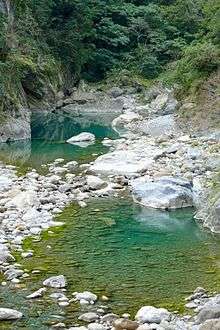
- 🌍 Shakadang Trail (砂卡噹步道). Shakadang Trail is also known as "Mysterious Valley Trail", which is named because more than 40 years ago a group of young folks entered the river valley and found it very secretive. This place has attracted more and more travellers, and thus everyone is used to calling it "Mysterious Valley". However, its name was reverted to "Shakadang Trail" in 2001, according to the name of the river. This trail is built along the river cliff so travelers can easily observe both the folded rocks and ecosystem beside the river shore. 4½ km after passing Sanjianwu (3D Cabin), the trail leads to an old Datong tribe village, which is a favorite of travelers. After the first curve, you can see running water from the cliff to the lake, a sight which has astonished many people. May is the season for You Tong flowers and makes the trail a pleasant floral walkway.
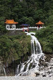
- 🌍 The Eternal Spring Shrine (長春祠) (Drive from the west exit of the Changchun Shrine Tunnel of Central Cross-Island Highway, then turn south to Liwu River Valley). The shrine and its walkways are sometimes closed, due to (supposedly) Typhoons. It seems like you are supposed to stay on the road, take your pictures and leave. But it is nevertheless impressive. The Changchun Shrine (Eternal Spring Shrine) recognizes the personnel who died during the construction of Central Cross-Island Highway. Rivers adjacent to the Changchun Shrine become the scattering falls, and the Highway Bureau named it after "Chanchun Falls" which is now the significant landmark on Central Cross-Island Highway. In 1987 the cliffs of the rivers destroyed the pavilion nearby the Changchun Shrine, but it was restored and reopened to the public 10 years later. In the back of the Changchun Shrine, there are stairs leading to Kuanyin Caves, Taroko Tower, the Bell Tower, and through a hanging bridge called "Heaven Trail", to Changuang Temple. The river valley next to the Changuang Temple has a calabash shape, and is accordingly named Calabash Valley (Hu-lu Gu).
- 🌍 Buluowan (布洛灣).
- 🌍 Swallow Grotto. The Swallow Grotto is a short easy walk along very nice views of the gorge, finishing under the impressive Zhuliu cliffs. Kiosk with restrooms available halfway.
- 🌍 The Tunnel of Nine Turns. The tunnel has been closed for some time, though; as of October 2013, this trail was even marked as "closed" on the free maps, so it may be closed longer-term. Check with the Visitor Center for up-to-date information.
- 🌍 Xiangde Temple.
- 🌍 Cave of Water Curtains / Baiyang Trail (水簾洞) (Entrance 1 km up the highway from Tiansiang bus stop.). Named for the cave at the end of the trail, where water literally pours down in sheets from the roof. Pack a poncho or use one discarded by other considerate hikers (or inconsiderate, depending on your point of view). Hiking to this point on the Baiyang Waterfall Trail takes you through many very long, completely unlit tunnels — an experience in and of itself. Be sure to take a torch, or you'll be walking in pitch black darkness.
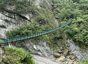
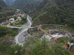
- 🌍 Lushui Trail (Suspension bridge & waterfall) (Alight at either Lushui or Heliu bus stops). Great and picturesque view. Further down the road in addition a great view from the 🌍 bridge.
Do
Hiking
Taroko national park features a lot of different hiking trails. For most of them solid sneakers are enough, if you want to leave the well prepared paths you need to get permission of the park administration. Don't forget to take enough water with you when hiking. Also, ask the information centre about the weather. At certain times of the year there is predictable heavy rainfall about the same time everyday and you want to make sure you aren't hiking at those times. Often rains start around 3pm, in which case you need to get an early start to do a couple of hikes in a day.

- 🌍 Dali Datong Trail (大禮大同步道). The trail starts near the Visitor Center and goes up through a forest, offering expansive views of the area and the Liwu river. The trail is of medium difficulty, consisting of mainly stairs and dirt paths. Once arrived at the top, you will hit some restricted areas. It takes about 2-3 hr total to go up and back down.
- 🌍 Lushui-Heliu Trail. An easy 2 km/1.3 mile (45 min) walk from the park office at Lushui to Heliu. Winds around short cliffs above the main road. Does pass through one dark tunnel, so bring a flashlight.
- 🌍 Jhuilu Old Trail (錐麓古道). Used to be part of an old cross-mountain trail through Taroko Gorge, starting near Swallows Grotto as it winds upwards through the green forest and coming out on a narrow cliffside path 700 m above the road but not more than a couple of meters across. Stops at the 3.1-km marker, as further tracks have high risks of rockfall and landslides. Hikers are limited to about 50 a day, so the trail is peaceful compared to the relative crowds below. Apply as early as you can as permits do run out. Apply at https://npm.cpami.gov.tw/en/index.aspx NT$500 for permit.
River tracing
- 🌍 Sanjhan. River tracing is available from the community centre in the nearby town of Sanjhan. There is a community centre from which you can rent all relevant gear for about NT$500. However, if you want to rappel down waterfalls or do anything complicated, it is recommended that you contact a tour agency as the community centre of Sanjhan does not arrange tours.
Taroko International Marathon
Every year in early November the Taipei Road Running Association and Taroko National Park closes the winding road through the gorge and host a marathon, half marathon, and 5-km fun run. The event is open to the public and anyone can participate by contacting the CTRRA through their website. If you plan on attending this event or just visiting the gorge during the marathon weekend, make sure you make your hotel and transportation reservations early and keep in mind that the road through the gorge will be closed for a good portion of the race day.
Buy
Various local aboriginal handcrafts are for sale in the gorge as well as some local liquor. On the road from Hualien to the park entrance are lots of roadside stands selling whatever fruit is in season.
Eat
Restaurants are in short supply in Taroko Gorge, and those at the service centers in Buluowan and Tiansiang are generally bad with inflated prices. The Visitor Center has a restaurant and a (relatively limited, compared to the average convenience store) choice of bottled drinks. The closest real convenience store is a 7-Eleven in Taroko Archway, about 10 minutes walking downhill from the Visitor Center. A packed lunch may serve as the simplest option for a day trip to the Gorge.
- Leader Village (near Bulowan). The hotel has a restaurant with aboriginal food that is fantastic. However, you may need to make reservations beforehand.
- 🌍 Tiansiang. 08:30-19:00. There are a couple of options in the Silks Place Hotel in Tiansiang. The café there is reasonable for a snack and an air-conditioned break from the heat if you are so inclined, but prices are high. The restaurant proper is quite fancy and expensive. Just across the parking lot from the Hotel are some several reasonably cheap food stalls, and one very small grocery store. A few small restaurants are available here that serve a variety of Chinese dishes. Some of the food is on display so even if you can't speak or read any Chinese, you should be able to fill your tummy with something you can palate. The phrase "Wo yao mai zhe ge" (I want to buy that) will serve you well.
- Shakadang Trail. Right before the Shakadong Trail turns into a wilderness trail (2-3 km?), there are a few food stalls run by members of the Taroko tribe. The food's cooked fresh, tastes good, and is fairly priced for the location. Wild boar sausage and mochi with ground nuts are NT$40 each, and a can of apple juice is NT$30. Closed promptly at 16:30 in November.
Sleep
In the gorge are several options in Tienhsiang, from the top-end five-star Silks Place Hotel and the Leader Village Hotel (more like motel) to budget hostels. However, most tourists choose to stay in Hualien, where there's a greater range of accommodation albeit with a time trade-off.
Budget
- 🌍 Catholic Hostel, Tienhsiang (花蓮縣秀林鄉天祥33號), ☎ +886 3 869 1122. A popular budget hostel, very basic rooms but reasonably clean. Staff is mostly non-English speaking. Bunk NT$300, single room NT$400.
- 🌍 Youth Activity Center, Tienhsiang, ☎ +886 3 8691111, e-mail: tsyac@cyc.tw. NT$1,000-1,200/bed.
- If you head 50 km further into the mountains, e.g. with a regular bus, there is the Kuan Yun Youth Activity Center for NT$500.
Mid-range
- 🌍 Taroko Lodge, No. 35-5, Minzhi, Hsiulin, ☎ +886 922 938 743. A bed-and-breakfast type of homestay located outside Taroko Gorge in Xincheng. Rooms are a little basic for the price, but the hosts are friendly, and will help out on self-guided tours and apply for hiking permits on your behalf. Bicycles are available for rent. NT$2500.
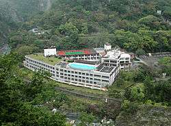
- Leader Village, 231-1 Fu Shih Village, Hsiulin, ☎ +886 3 861-0111, e-mail: blw@leaderhotel.com. Located in the Pulowan park and run by charming aboriginals. Three meals available, and dance and music shows on certain nights. NT$3,500.
Splurge
- 🌍 Silks Place (晶英酒店), 18 Tienhsiang Rd, Hsiulin, ☎ +886 3 869-1155, fax: +886 3-869-1160. NT$9,000.
Camping
- Lyushui Heliu Campground (17 km into the gorge on the left side of the road.). There are about 10 parking spaces. A cold water shower and restroom, and drinking water are available. Reservations are not accepted. The campground is a semi-developed terrace with access and good views of the river. It is very close to the road, but since there is hardly any traffic at night, that should not be a problem. NT$200.
Backcountry
Backcountry hiking is technical and requires permits from the authorities.
Stay safe
- Rock fall. In May 2004, the Hualien area experienced a strong earthquake resulting in the mountain-sides becoming unstable in many areas. Therefore, it is strongly advised not enter the gorge during or just after periods of prolonged heavy rainfall. There are several signs in English marking the more dangerous areas and hard hats are provided at the Tunnel of Nine Turns.
- River activities. The river that passes through the gorge is extremely swift and dangerous. Care is especially required after heavy rainfall.
- Snakes. There are numerous signs up warning visitors of poisonous snakes. Whilst snake sightings in the gorge are uncommon some of Taiwan's snakes can be deadly and hence all unrecognised snakes should be treated with caution. Most snakes are shy so to minimise the likelihood of encountering a snake make plenty of noise whilst walking to alert them of your approach.
Go next
- Hualien - The biggest city in East Taiwan.
- Hualien Ocean Park - Hualien's biggest man-made tourist attraction.