Taal Volcano
Taal Volcano is a complex stratovolcano in the province of Batangas, Philippines. The nearest town, and the usual base for trips to the volcano, is Tagatay in Cavite province.
The volcano proper forms Taal Volcano Natural Park, while the lake forms the Taal Volcano Protected Landscape, which includes areas within the lake's coastline.
Understand

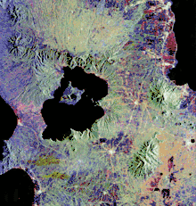
Taal Volcano is best known as the world's smallest volcano, and one known example of "a lake with a volcano with a lake". It is an active volcano, with a history of 33 destructive eruptions. It is the second most active volcano in the Philippines, next after Mount Mayon, and also one of the "Decade Volcanoes".
Taal Volcano forms a chain of volcanoes in the Philippines from prehistoric times, resulting from the subduction of the Eurasian Plate and Pacific Plate.
The volcano is most viewed from the Tagaytay, a highland city in Cavite, and considered one of the picturesque landscapes of the Philippines. Package tours to Taal Volcano are available from the city. Taal Volcano is also one of the provincial symbols of Batangas, appearing on the new provincial seal and flag.
The volcano and the lake form the large Taal Volcano Protected Landscape (TVPL) designated as a national park since 1967.
History
Taal Volcano is an active volcano, with its earliest recorded eruption in 1572. The lake and the volcano were first named as Bonbon (or Bombón), which also gave the historical names of the present-day town of Taal and the province of Batangas.
Taal Volcano's most destructive eruptions occurred in 1755 and 1910. The very destructive 1755 eruption destroyed the original downtown of Taal, now part of the little town of San Nicolas, as well as the original town center of present-day Lipa, now part of the town of Mataasnakahoy, and is well recorded in an account by a Spanish priest. Ash and mud from the 1755 eruption has also been carried by storms into the village of Caysasay (present-day Taal) and as far Balayan.
Landscape

The volcano proper forms the Volcano Island, composed of seven volcanic cones and the caldera lake. Taal Lake also forms the volcano, making the system complex. Volcanic activity can be noticed through changes in Taal Lake; some fish kill incidents on the lake are blamed on volcanic activity, though overcrowded fish pens (baklad) are often the cause.
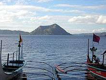
From Tagaytay, Taal Volcano, alongside Taal Lake, dominate the landscape, with the dormant cone Binintiang Malaki being the most prominent. The volcano is covered by vegetation up to the tree line at the crater lake. On the base are some villages relying on fishing in Taal Lake and agriculture in the fertile soil of Volcano Island.
Flora and fauna
Taal Lake is home to the tawilis (Sardinella tawilis), a species of sardine endemic to the lake. It is often served as a local dish in the surrounding area, but overfishing is threatening the tawilis population, so it is designated an endangered species in 2019 by the International Union for the Conservation of Nature (IUCN), and a closed season is implemented to allow the fish to increase in number.
Get in
To Volcano Island

The city of Tagaytay nearby is used as the starting point, but some may travel directly to the boat launching point in Talisay. Another launching point can be found to the west of the volcano, in barangay Buso-Buso in Laurel town.
Access to the actual volcanic area is by boat. Boats leave anywhere from the lakeside, and competition is fierce. The prices are fixed at ₱2000 per boat, for up to 6 people but you can reduce it to ₱1200-1500 if you bargain. Operators may tell you that you are not allowed to share with other travellers, but this is not true.
You can take a 15-min outrigger boat ride to the volcano that is within the lake. As you head from Tagaytay city toward the lake, many touts may jump in front of your vehicle offering boat rides - they take a commission. If you know where to go, however, you can catch a boat directly from the boat owners.
Fees and permits
Get around
Once on the island, the boat guides will herd you to a point where you can go horseback riding to the volcano. It takes about 30-45 minutes and is quite bumpy. The guides with the horses take you to the top which is very spectacular and you can explore the top for as long as you want.
Another option is hiking which will take 50 to 90 minutes, though the hills and terrain may put some people off.
When up at the volcano, watch out for guides trying to show groups of tourists heating tricks. These consist of getting a can of soft drink or water, cutting the can or bottle in half and watching the ground heat boil the water or liquid which is pretty cool to see, and you can boil an egg if you bring one with you!
See
Do
Buy
Eat
Drink
Sleep
There are no accommodations available on Volcano Island, even in the barangays. The nearest places to sleep can be found at Talisay, Tagaytay, Lipa and Taal. Backcountry camping is not allowed for volcano safety reasons.
Stay safe
Taal Volcano is an active volcano: volcano safety advice applies when visiting.