Shenandoah National Park
Shenandoah National Park is a United States National Park in the state of Virginia. The park is one of the most popular touristic destinations in the eastern part of the USA visited by well over one million people a year. Although hundreds of thousands drive along Skyline Drive in mid-late October to admire vibrant fall foliage, the park is no less spectacular (and a lot less crowded) in spring when the wildflowers and trees are in full bloom.
Understand
History
The oldest rocks in the Blue Ridge Mountains were created over a billion years ago as magma deep within the earth's crust moved upward. Over eons it cooled, fractured, and was joined by younger metamorphic rocks formed from sedimentary deposits. All were altered and eroded to shape today's granite peaks and sylvan hollows.
Around 8,000-9,000 years ago, but seconds in geologic time, the first traces of humans were recorded on the land that would become the park. Native Americans seasonally visited the area to hunt, to gather nuts and berries, and to find sources for and to make their stone tools.
Europeans first experienced the beauty of these mountains less than 300 years ago. First came hunters and trappers, and soon after 1750 the first settlers moved into the lower hollows near springs and streams. Over the next 150 years many hundreds of families built homesteads, mills and stores and planted orchards and crops. The mountains were logged and minerals were mined. Vacation resorts were established to allow guests to experience the mountain views, healthy water, and cool breezes. American society became urban, industrial, and yearned for special places for recreation and refuge.
In the early 20th century the first calls for national parks in the east were heard in the United States Congress. It would be two decades before Shenandoah National Park was authorized and another ten years before it was established. During that time President Herbert Hoover and his wife Louise Henry Hoover established their Summer White House on the Rapidan River, the construction of Skyline Drive began, the Civilian Conservation Corps was established and moved into the park area, and over 450 families of mountain residents were relocated from the Blue Ridge; many of these families were vehemently opposed to losing their homes and communities.
With the establishment of the park in December 1935, the CCC began to build visitor facilities throughout the mountain, areas that were initially racially segregated. The core of the park's development was completed by the beginning of World War II and, to a great extent, the mountains were released to nature.
Landscape

Shenandoah National Park includes 300 sq mi (780 km2) of the Blue Ridge Mountains in the central Appalachians. The park rises above the Virginia Piedmont to its east and the Shenandoah Valley to its west. Two peaks exceed 4,000 ft (1,200 m). The range of elevation, slopes and aspects of mountain and hillsides, rock and soil types, precipitation conditions, and latitude interact to create a mix of habitats.
The park’s biota and natural features include: well-exposed strata of the Appalachians, one of the oldest mountain ranges in the world; diverse animal and plant populations and habitats; migratory bird stop-over points; and forested watersheds that perpetuate numerous streams flowing from uplands to lowlands.
Shenandoah is the largest fully protected area in the mid-Appalachian region.
Flora and fauna
Shenandoah serves as a refuge for many species of animals otherwise pressured by human activities, development and other land uses. There are over 200 resident and transient bird species, over 50 species of mammals, 51 reptile and amphibian species, and 30 fish species found in the park.
Climate
The Atlantic Ocean, and in particular the Gulf Stream, plays an important role in Virginia’s precipitation regime. Winter storms generally track from the west to the east and in the vicinity of the east coast move to the northeast paralleling the coast and the Gulf Stream. This shift to northeast results partly from the tendency of storms to follow the boundary between the cold land and the warm Gulf Stream. When sufficiently cold air comes into Virginia from the west and northwest, frontal storms can bring heavy snowfall. Thunderstorms occur in all months of the year, with a maximum in September and minimum in February. Storms and high runoff conditions can occur year-round in Shenandoah. Most locations receive 100-150 cm of precipitation per year. The average annual precipitation at Big Meadows is 132 cm, which includes about 94 cm of snow. South to southwest winds predominate, with secondary maximum frequency from the north. Lower elevation areas of the park experience modified continental climate, with mild winters and warm, humid summers. The mean annual temperature in the lowland area at Luray averages 12 degrees C, and average annual precipitation is 91 cm, with about 43 cm of snow.
Higher elevation areas of the park experience winters that are moderately cold and summers that are relatively cool. The mean annual temperature at Big Meadows averages about 9 °C. Mean maximum daily temperatures in July average about 6 °C cooler at Big Meadows than in the lowland areas of the park. Temperatures in January range from about –7 °C to 4 °C and in July from about 14-24 °C. Snow and ice are common in the winter, but they usually melt quickly, leaving the ground bare. Occasional major snow or ice storms can cause considerable damage to the trees within the park.
Get in

There are several ways to get into the park:
- Route 522 - the North (Front Royal)
- Route 211 - crosses the park in the northern part at Thornton Gap.
- Route 33 - crosses in the southern part
- Blue Ridge Parkway & I-64 - the South (not far from Waynesboro)
Fees and permits
Shenandoah National Park is one of the NPS units that charge an entry fee. The following fee types are available:
- 1-7 days per vehicle: $10 Dec-Feb, $15 Mar-Nov
- 1-7 days per motorcycle: $10
- 1-7 day per person (e.g. visiting by bicycle, bus): $5 Dec-Feb, $8 Mar-Nov
- Annual pass (may be signed by up to two people): $30
There are several passes for groups traveling together in a private vehicle or individuals on foot or on bike. These passes provide free entry at national parks and national wildlife refuges, and also cover standard amenity fees at national forests and grasslands, and at lands managed by the Bureau of Land Management and Bureau of Reclamation. These passes are valid at all national parks including Shenandoah National Park:
- The $80 Annual Pass (valid for twelve months from date of issue) can be purchased by anyone. Military personnel can obtain a free annual pass in person at a federal recreation site by showing a Common Access Card (CAC) or Military ID.
- U.S. citizens or permanent residents age 62 or over can obtain a Senior Pass (valid for the life of the holder) in person at a federal recreation site for $80, or through the mail for $90; applicants must provide documentation of citizenship and age. This pass also provides a fifty percent discount on some park amenities. Seniors can also obtain a $20 annual pass.
- U.S. citizens or permanent residents with permanent disabilities can obtain an Access Pass (valid for the life of the holder) in person at a federal recreation site at no charge, or through the mail for $10; applicants must provide documentation of citizenship and permanent disability. This pass also provides a fifty percent discount on some park amenities.
- Individuals who have volunteered 250 or more hours with federal agencies that participate in the Interagency Pass Program can receive a free Volunteer Pass.
- 4th graders can receive an Annual 4th Grade Pass that allows free entry for the duration of the 4th grade school year (September-August) to the bearer and any accompanying passengers in a private non-commercial vehicle. Registration at the Every Kid in a Park website is required.
In 2018 the National Park Service will offer four days on which entry is free for all national parks: January 15 (Martin Luther King Jr. Day), April 21 (1st Day of NPS Week), September 22 (National Public Lands Day), and November 11 (Veterans Day weekend).
Get around
The best way to enjoy the area is by taking any of the numerous hiking trails along the road. There is no public transportation in the area and the only way to get to the trails is by vehicle or by bicycle.
See
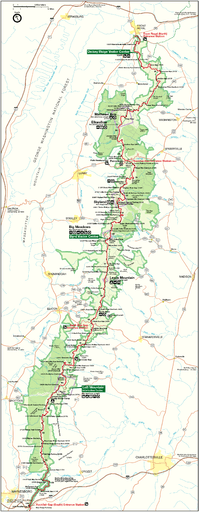
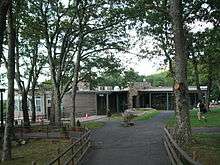
- Dickey Ridge Visitor Center (mile 4.6 on Skyline Drive). Facilities: restrooms, information desk, exhibits, videos, sales, publications, maps, backcountry permits, and first aid.
- Harry F. Byrd, Sr. Visitor Center (mile 51 on Skyline Drive). Facilities: restrooms, information desk, videos, sales, publications, maps, backcountry permits, and first aid.
- Loft Mountain Information Center (mile 79.5 on Skyline Drive).
- 🌍 Rapidan Camp (Camp Hoover), ☎ +1 540 999-3500. Herbert Hoover's cabin, The Brown House, is historically refurnished to the 1929 era with a ranger-guided tour in high season.
Do
Driving the Skyline Drive

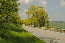
The Skyline Drive, which is designated a National Scenic Byway, runs 105 miles north and south along the crest of the Blue Ridge Mountains and is the only public road through the park. You can enter the drive at four places: Front Royal near Rt. 66 and 340, Thornton Gap at Rt. 211, Swift Run Gap at Rt. 33, and Rockfish Gap at Rt. 64 (where the drive continues south as the Blue Ridge Parkway). The maximum speed limit on the drive is 35 mph and it takes about three hours to travel the entire length of the park. To help drivers locate points of interest in the park, the drive features concrete mileposts on the west side of the road. The mileposts begin with 0 at Front Royal and continue to 105 at the southern end of the park. All park maps and information use these mileposts as a reference. For example, Big Meadows, the largest developed area in the park is located near the center of the park, at milepost 51. The drive features seventy five overlooks with stunning views. The drive also leads through Marys Rock Tunnel (just south of Thornton Gap entrance from Route 211, near milepost 33).
Hiking
With over 500 miles (800 km) of hiking trails, including over 100 miles of the Appalachian Trail, the park is a premier destination for hikers.
- An especially popular hike is Old Rag (6 hours, 7.2 miles; elevation gain: 2,510 feet), a loop that covers forests, hollows, and rocky top. The peak, at 3,291 feet, has great views of the park and the surrounding countryside. The trail is typically traversed by ascending along the Ridge Trail, which is a strenuous trail of approximately 3 miles that includes a rope climb and rock scramble, and then descending along the Saddle Trail and Weakley Hollow Fire Road. Some hikers opt to hike in the opposite direction, which has a longer ascent but may be easier when descending the rock scramble. To reach the trailhead, travel north from Madison about 13 miles on Route 231, and turn left on Nethers Road. The small parking area at the trailhead is now closed, but a much larger parking area is available 0.8 miles from the trailhead.
- Another popular and gentler hike is Stony Man (1.5 hours, 1.6 miles, pets not allowed), one of the most scenic trails in the skyline drive that ends in a cliff with a beautiful overlook. The walk passes over the summit of Stony Man Mountain, at 4,010 feet. The trailhead begins at mile 39.1 of Skyline Drive, just inside the north entrance to Skyland.
- A hike near Stony Man is Little Stony Man (1 hour, 0.9 miles), a climb with breathtaking views. The trailhead begins at mile 41.7 of Skyline Drive. Alternatively you can reach Little Stony Man from Stony Man by using part of the Appalachian Trail, then walk down Little Stony Man, and return to the beginning of the Stony Man walk via the Passamaquody Trail.
- The most popular waterfall trail leads to the Dark Hollow Falls (1.5 hours, 1.4 miles, pets not allowed; elevation gain: 440 feet). The trail descends steeply to the head of the falls and then to the foot. The return trip to the parking may be exhausting to some. The trailhead begins at mile 50.7 of Skyline Drive, just north of the Big Meadows. The hike can be turned into a loop that reaches the Rose River Falls for a 3-hour hike through woods and along several streams with cascades and waterfalls.
Buy
There are maps and books for sale at the visitor centers. There you can also buy bundles of T-shirts and baseball caps with the Park logo and a range of souvenirs of the area.
Eat

The park has 6 picnic grounds and an uncountable number of spots where people can eat their own food, but build fires only in designated areas with grates. There are camp stores at or near all designated camp grounds, and only a few places where food is being served:
- Elkwallow, Mile 24.1, Skyline Dr. Limited range of sandwiches and grilled food. No seating spaces indoor but there are picnic tables outside.
- Skyland, Mile 41.7, Skyline Dr. This is part of the Skyland complex and offers dining with a view.
- Big Meadows Wayside, Mile 51.2, Skyline Dr. Offers eat-in and take-away food. Country food and cakes.
- Big Meadows Lodge, Follow signs from Skyline Drive mile 51.2. Dining room service in a rustic setting.
- Loft Mountain, Mile 79.5, Skyline Dr. Seating inside and outside.
Drink
There are no bars in the area and only a few dining spots (see the Eat section).
Sleep
Lodging
There are three lodges in the park located at Skyland, Big Meadows and Lewis Mountain. These lodges are about the only accommodation in the park and they can be fully booked for months, especially during high season. Be careful about making reservations. There is a company called National Parks Reservation Service that charges a 10% booking fee and a cancellation fee of $15. Reservations should be made with Aramark which runs the park hotels.
- Skyland Resort, Mile 41.7, Skyline Dr, toll-free: +1-888-896-3833. $74-$269.
- Big Meadows Lodge, Mile 51.2, Skyline Dr, toll-free: +1-888-896-3833. $84-$159.
- Lewis Mountain Cabins, Mile 57.5, Skyline Dr, toll-free: +1-888-896-3833. $30-$119.
Camping
There are four campgrounds that offer sites on a first-come, first-serve basis and by reservation at phone number +1-877-444-6777:
- Matthews Arm, Mile 22.1, Skyline Dr. 167 sites, flush toilets, dump station, camp store two miles south at Elkwallow Wayside. $15.
- Big Meadows, Mile 51.2, Skyline Dr. 220 sites, flush toilets, coin showers, coin laundry, dump station, camp store. $20.
- Lewis Mountain, Mile 57.5, Skyline Dr. 31 sites, flush toilets, coin showers, coin laundry, campstore. First-come first-serve only. $15.
- Loft Mountain, Mile 79.5, Skyline Dr. Flush toilets, coin laundry, dump station, campstore. $15.
There are also cabins:
- PATC Cabins, ☎ +1 703 242-0693. Locked primitive cabins maintained by the Potomac Appalachian Trail Club (PATC). There are six of them in the park.
Stay safe

- Bears. The park has a resident colony of black bears. It is important not to feed the bears. A wild bear will run away as soon as it notices there are humans nearby, unless it associates people with food by being fed previously. If you encounter a bear and it approaches you, make loud noises by yelling and clapping your hands so that the bear notices that you are a human. If you see one while you are in a vehicle, remain in the vehicle.
- Snakes. If you see a snake, leave it alone! All wild animals are protected. There are poisonous snakes including copperheads and rattlesnakes so use ordinary precautions, wear shoes and carry a flashlight after dusk.
- Ticks. Several species of ticks are common in the park and there is a risk of tick-borne diseases if one bites you. Take precautions like using tick repellents, wear light colored clothing, long sleeves, and long pants with pant's legs tucked into socks if you are in tick habitat. Always check for ticks afterwards. You may not notice a small tick, so if you feel sick after visiting an area where ticks are common tell your doctor of the possibility of a tick-borne disease.
Go next
Luray Caverns are a short drive from the Thornton Gap Entrance Station. To reach the caverns, drive past Luray and turn right at the sign. The caves are the most extensive of the East Coast and feature large columns of white and pink stalactites, reflection pools, and the Great Stalacpipe Organ that operates by gently striking selected stalactites.