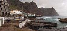
Santo Antão
Santo Antão is the second biggest of the Cape Verde islands.
Understand
Santo Antao is a surprising island. When you land at the ferry port it appears to be dusty and sandy like many of the other islands but in half an hour you can be driving up steep, windy roads and suddenly find yourself in pine forest and skimming the edge of a volcano! Much of the island is unexplored, but the best part to head for is the north east corner where there is great hiking. In Ponto do Sol you can scuba dive, hike or rock climb in a very picturesque setting. Accommodation is inexpensive and would suit all budgets. Santo Antao is the most northern and the most western island of the archipelago, with the area of 779 km², maximum length of 43 km and maximum width of 24 km. The highest point is Topo de Coroa, 1,979 m high.
Get in
By plane
You cannot get to Santo Antão by plane. There used to be an airport near Ponto do Sol, but now it's abandoned.
By ferry
There are 2 or 3 ferries per day between Porto Novo, Santo Antão and Mindelo, São Vicente . The journey takes 60 mins.
Get around
By car
It might be reasonable to rent a car in Porto Novo for 50 euro
See
- Farol de Boi (Farol Fontes Pereira de Mela), Pontinha de Janela. The biggest and the oldest lighthouse of Cape Verde. Built 1886, now abandoned.
- Statue of Santo Antonio, Vila das Pombas.
- Cova (between Porto Novo and Ribeira Grande). A valley in a crater of an extinct volcano
Do

trekking