Saharan Chad
Other destinations
Understand
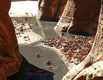
The Saharan region covers roughly the northern third of Chad, including Borkou-Ennedi-Tibesti Prefecture along with the northern parts of Kanem, Batha, and Biltine prefectures. Much of this area receives only traces of rain during the entire year. Scattered small oases and occasional wells provide water for a few date palms or small plots of millet and garden crops. In much of the north, the average daily maximum temperature is about 32 °C during January, the coolest month of the year, and a vicious 45 °C during May, the hottest month.
Get in
Get around
See
Do
Eat
Drink
Stay safe
Go next
gollark: That would be *interesting*.
gollark: This was for redirection to *chat*, though.
gollark: My early attempts at this did some horrible, horrible bodging with `term`.
gollark: You would need to get `write` too. And so many CC programs do direct term stuff.
gollark: HERESY.
This article is issued from Wikivoyage. The text is licensed under Creative Commons - Attribution - Sharealike. Additional terms may apply for the media files.