Åndalsnes and Romsdal valley
Åndalsnes is a town at the mouth of Romsdal valley in the western county Møre og Romsdal. It has attracted some unfavourable comments on travel boards but it's a superbly located transport hub and the Romsdal valley is one of the most monumental and romantic valleys of Norway. Åndalsnes itself is merely a village, but the valley and surrounding mountains and fjords are among the greatest in Norway. Åndalsnes is a centre for mountaineering in Norway and calls itself "alpine town at the fjord". The Romsdal valley and its iconic summits has attracted countless artists since the early 1800s.
Understand
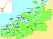
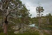
Romsdal is the deep valley stretching some 40 km from the county line near Bjorli to the Romsdal fjord at the small town of Åndalsnes. Romsdal is the valley of the great Rauma river and because of its centrality has given name to the whole county.
Åndalsnes sits at the mouth of Rauma river, opposite the village of Veblungsnes (the former centre), which has a characteristic parish church. Åndalsnes is also the terminal station for the Raumabanen (railway line) running through the valley. Near Åndalsnes the main Romsdal valley converges with the shorter but even more dramatic Isterdal valley, home to famous Trollstigen hairpin road and mountain pass and more wild summits. The lower parts of the two valleys are dominated by the confluence of rivers Rauma and Istra: the delta they create and the meanders through which they flow. The valley floor is surprisingly flat and even between these wild mountains. About 2/3 of the area is above the treeline.
The Romsdal valley allows easy connection to the inland counties of Oppland and Hedmark, and is in fact a western continuation of the great eastern valley Gudbrandsdalen. Lesjaskogsvatnet lake is exactly at the watershed and water from the lake flows both east and west. Åndalsnes' central location made it a transport hub and old trading post. Most visitors by car, train or bus will eventually drive through the valley. The valley has given its name to the district surrounding the Moldefjord/Romsdalsfjord, as well as the entire county.
The Romsdal valley begins around the county line in the highlands where the valley and the river quickly descends through gorges (with lovely rapids and waterfalls) to the relatively even and low valley floor. The road and the railway then runs between some of the highest cliffs and highest waterfalls in Europe. Nearby Eikesdalen valley (as well as Sunndalen) are also home to some of the highest waterfalls in Europe. All waterfalls in Romsdal valley are easily accessible and visible from the car window and from the train (Mongefossen is perhaps the tallest waterfall visible from a train).
Åndalsnes and Romsdal valley were early key tourist destinations in Western Norway. In particular affluent English gentlemen were attracted by the salmon angling in the great landscape. Properties were purchased and hotels established by the English. The alpine pioneer William Cecil Slingsby visited Romsdal, in addition to the Sunnmøre alps (around Hjørundfjord) and Jotunheimen.
Romsdal alps
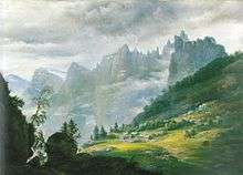
Romsdal with Isterdalen and nearby Isfjorden and Eikesdalen valleys are home to the Romsdal alps, a group of breathtaking alpine summits. These are the most accessible of Norway's alpine peaks, easily viewed from the main road and railway the runs close. The iconic Romsdalshorn stands opposite the 1000-metre vertical rock face Trollveggen, famous among climbers and BASE jumpers (now forbidden). Trollveggen is in turn surrounded by sharp peaks and more forbidding rock faces. The Isterdalen valley and Trollstigen (on Trollveggens rear) is home to peaks aptly named Bishop, King and Queen, as well as the Troll's claws. Eikesdalen valley is also a hidden gem of imposing mountains around the lovely lake.
Raumabanen
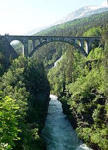
Raumabanen or the Rauma Railway runs between Dombås and Åndalsnes, the name "Rauma" refers to the river along which the line runs. The rail line runs parallel to road E136 and mostly offers the same views. The railway was an engineering achievement in the 1910-20s, particularly the double horseshoe curve (including Kylling bridge) system at Verma - the system was constructed to allow the train climb the steep, narrow valley and cross the gorges at Verma where the high valley (Bjorli/Lesja at upper part of Gudbrandsdalen) plunges into the low valley (Romsdal valley proper). There are several great masonry arc bridges on the line: one crossing a river gorge at Dombås, one crossing the gorge and waterfall at Verma, and a somewhat smaller crossing the river near the county line. All bridges are visible from or within a short walk from the main road. Raumabanen is 110 km and construction lasted about 14 years. The complicated construction of Kylling bridge lasted about 9 years. 600 men worked 15 years to complete the line.
History
Åndalsnes played a key role in the dramatic days following the German invasion April 9, 1940. British troops landed at Åndalsnes to support the Norwegian Army and the town was totally destroyed by the subsequent German bombing. The British troops landed at Åndalsnes (as well as Namsos) were engaged in the first Allied direct combat with German troops during the war. The King, cabinet and Bank of Norway's gold and cash holdings were evacuated through Åndalsnes amidst heavy fighting in a bold and legendary operation. The Raumabanen railway was then strategically important as it connected Oslo and East Norway to the protected harbour at Åndalsnes. Later during the war the railway was the target of sabotage intended to interrupt German transport of troops and supplies.
More than 300 years earlier, Scottish mercenary troops landed in the Åndalsnes and Romsdal valley en route to join the war in Sweden. The Scottish troops marched through the valley and passed Otta in Gudbrandsdalen where they were slaughtered by local militia in a legendary ambush.
Towns
- Åndalsnes - where valley and fjord meet, end station for the railway, regional centre
- Bjorli - highest point of the valley, tipping point between Gudbrandsdal and Romsdal valleys
Get in
- Buses from Ålesund, Molde, Kristiansund and, in summer, Geiranger via Valldal. Note: Bus to/from Valldal via Trollstigen from around June 20th.
- By car


- Road 63 from Geiranger via Valldal and Trollstigen (summer only). Note: Trollstigen mountain pass usually opens late May (between May 10 and June 10), closes late October
- Road 64 from Molde, Kristiansund, Eikesdalen and Trondheim
- There is no airport in the area. The nearest airports are Ålesund (122 km) and Molde (67 km plus a ferry). Oslo international airport at Gardermoen (403 km) has good connections by rail or road. The given distances are by road from Åndalsnes.
By rail
The Rauma railway terminates at Åndalsnes and runs parallel to road E136, and are connected to both Oslo, Oslo airport and Trondheim via Dombås junction. This is also a very scenic piece of railway. Trains from Oslo or Trondheim via Dombås go along the Romsdal, one of Norway's most scenic lines. This is the only railway line in Møre og Romsdal and Åndalsnes is the line's endstation. A Minipris (Non refundable discount) ticket from Oslo to Åndalsnes can be purchased from as low as 199 kr at www.nsb.no
Get around
Åndalsnes itself is only a village, and can be covered on foot. Outside the village, distances are long and transport is essentially the same as Get in.
Bus or 10 minute ferry to Molde, ferry from there to Vikebukt and return by bus (from Ålesund) makes a great day out. A return trip to Geiranger with ferry from there to Hellesylt and back is easily done in a day - given an early start if you are going by bus.
See
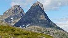
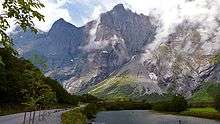
- 🌍 King and Bishop summits, Road 63 (Trollstigen) (Drive road 63). Mountains named after chess pieces, the 'Bishop' being a perfect example, can be seen early on the scenic drive to Geiranger. Free.
- 🌍 Trollstigen mountain pass, Åndalsnes-Valldal (Road 63). summer only (late May - October). The Trollstigen, a mountain road climbing the pass between Isterdalen valley in the North and Valldal valley in the South. This road is the major attraction in this area and one of the most visited destinations in Norway, frequently named the most scenic drive in Norway. It is a elegant road and engineering achievement amidst iconic mountains and wild waterfalls. Part of road 63 between Åndalsnes and Geiranger, designated as one of Norway's national tourist routes. During high season the traffic load is high at noon (11 to 14 o'clock), traffic jams occur, try to drive early morning or evening. Free.
- 🌍 Trollveggen. The Trollveggen, Europe's highest vertical and overhanging rock face can be seen to the right of the railway as you leave Åndalsnes. Road E136 also passes the panorama point. Panorama also includes countless peaks (Trolltindane) and other great walls.
- 🌍 Kylling railway bridge (Kylling bru), Verma (Rauma railway or road E136). Elegant mason arc bridge across river Rauma Free..
- 🌍 Romsdal valley (Rauma railway or road E136). The impressive Romsdal valley is a 1500-metre deep canyon in the bedrock, stretching some 40 km from Bjorli to Åndalsnes. The wonderful Rauma river alternates between wild waterfalls and tranquil salmon pools. The entire Romsdalen valley stretching from Åndalsnes to Bjorli on Road E136. Waterfalls at Monge, Verma and Sletta. Mountains Trolltindane (including Trollveggen), Romsdalshorn, and Mongegjura.
- 🌍 Grytten church (Grytten kirke). Red painted octagonal wooden church at Veblungsnes, close to road E136.
- 🌍 Eikesdalen (valley) (Route 64 and 660). Eikesdalen valley with the famous Mardøla waterfall, the lovely lake, the wild summits and the great canyon is worth the detour from Åndalsnes.
Do
Drive,or go by bus, up Trollstigen road which is located some 15 kilometres outside Åndalsnes. Trollstigen is a road that is encircled by enormous mountains and goes in sharp curves up the mountain side. The road is normally closed from October to May, but is open during the summer months. On the top one has a spectacular view over the valley and the Trollstigen road. Route 63 through Trollstigen is Åndalsnes-Geiranger is a national scenic road.
Outdoor
- Åndalsnes with its valleys (Romsdalen and Isterdalen) is the centre for Norwegian alpine sport, rock face climbing and mountaineering. There are also endless opportunities for pleasant walks on paths in the mountain vallies as well as challenging scrambles to impressive summits. Warning: Do not walk on glaciers without proper equipment and experience.
- Non-climbers can visit the top of Trollveggen, a six hour hike from Trollstigen. You can also hike along the Romsdalseggen, a seven hours popular trip along the ridges over Romsdal. Warning: Experience and solid boots needed, contact a local guide if you do not know the route or are not familiar with Norwegian mountains.
- 🌍 Åndalsnes Golf Course (Rauma Golfbane), Setnesmoen Åndalsnes/Veblungsnes (3 km from Åndalsnes centre). May-October. This hilly 9-hole course lies in beautiful surroundings at Setnesmoen near Åndalsnes. This was where golf started in Norway. The English salmon lords held golf tournaments in Åndalsnes as early as 1905, on the site of the current golf course. 250 kr.
- 🌍 Rauma Ski Resort (Rauma skisenter) (Skorgedalen right across the fjord from Åndalsnes, drive via Isfjorden). A small and nice alpine skiing hill and lift.
- 🌍 Bjorli ski reosrt, Bjorli (Dombås-Åndalsnes along E136 or Rauma railway). Bjorli ski resort does not have big and very steep hills, but plenty of snow and long season. The highest village in Romsdalen valley, at the county border.
Eat
Drink
Sleep
- 🌍 Åndalsnes Camping (Located on the riverside about 2.5 kilometres upstream from the village. When on foot stick to the northern shore of the river and cross the footbridge to end up near the campings reception), ☎ +47 71 22 16 29, e-mail: epost@andalsnes-camping.no. Tent: kr 130, Cabin: kr 395-950.
- 🌍 Grand Hotel Bellevue (Near the station), ☎ +47 71 22 75 00, e-mail: booking@grandhotel.no. The hotel has excellent views over the wide Moldefjord - and fine meals, buffet and set in different restaurants.
- 🌍 Hotel Aak (5 kilometers outside the centre, south along main road), ☎ +47 71 22 17 00, e-mail: booking@hotelaak.no. This small hotel has an interesting history which dates back from 1850, but it was fully renovated in 1998. The hotel has only 16 rooms and a small restaurant.
- 🌍 Åndalsnes Vandrerhjem, Setnes, ☎ +47 71 22 13 82, e-mail: andalsnes@hihostels.no. Youth hostel located across the river direction Ålesund. Dorm: kr 290 including breakfast (10% discount with HI membership), Bed linen: kr 60.
Connect
Go next
- Visit Valldal via the Trollstigen. Trollstigen ("The Troll Pathway") is a mountain road on national highway 63 between Åndalsnes and Valldal in West Norway. It is one of Norway's major attractions due to its steep incline and eleven hairpin bends climbing cliffs and steep hills until the mountain pass. Trollstigen is closed during the fall and winter months. A normal opening season stretches from the mid of May to October. Road 63 Åndalsnes-Valldal-Geiranger was named National Tourist Route by the government.
- From Valldal continue to Geiranger.
- Continue by rail towards Dombås, Lillehammer and Oslo on the scenic Raumabanen line.
| Routes through Åndalsnes and Romsdal valley |
| Dombås ← Bjorli ← | E |
→ Åndalsnes → Ålesund |