Quetico Provincial Park
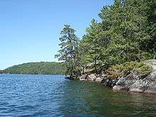
Quetico Provincial Park is a vast wilderness area in northern Ontario, adjoining Minnesota's Boundary Waters Canoe Area. It is famous for its array of small- to medium-sized lakes and the wildlife they provide a home for.
Understand


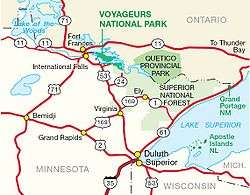
It is known for its excellent canoeing and fishing. This 4,760-km² (1,180,000-acre) park shares its southern border with Minnesota's Boundary Waters Canoe Area Wilderness, which is part of the larger Superior National Forest. These large wilderness parks are often collectively referred to as the Boundary Waters or the Quetico-Superior Country.
The Dawson Trail Heritage Pavillion contains exhibits about the past of Quetico. Downstairs, the John B. Ridley Research Library, which is open the public, provides resources for the study of biology, geology, history, culture, archaeology, and wilderness management of Quetico and environs. The collection includes books, articles, pamphlets, maps, slides, photographs, and oral history tapes. There are also index card files on topics such as chronological history, biography, lake names and birds.
History
In 1909, the Government of Ontario established the Quetico Forest Reserve. Early the same year, the United States federal government established the adjacent Superior National Forest and Superior Game Refuge, which eventually became the Boundary Waters Canoe Area Wilderness. Quetico Provincial Park was created by the Ontario Legislature in 1913, but road access wasn't built until 1954.
The creation of the park created a conflict with the Lac La Croix First Nation who had a reserve in the park. In 1915, the province cancelled the band's right to the reserve and relocated the people on the reserve. The grievances of the band were not addressed until 1991 when the Minister of Natural Resources made an apology in the Legislature for the move. Wildman also addressed one of the band's request to allow mechanized boats in the park for the purposes of guiding.
The origin of the park's name is a mystery. Locals say the park is named after the "Quebec Timber Company"; however, no such company existed. The name may also be a version of the French words quête de la côte, which means "search for the coast". It may also be from an Ojibwe name for a benevolent spirit who resides in places of great beauty.
Landscape
Quetico is near the southern edge of the Canadian Shield, an exposed 1600-km expanse of ancient Precambrian rock, some of which is among the oldest exposed rock in the world. The park consists of a large number of "young" lakes (only tens of thousands of years old) contained by this ancient bedrock. Due to its proximity to the Laurentian Divide, the park can be considered to be in the headwaters of the Hudson Bay watershed. This helps to make it, along with the adjacent Boundary Waters Canoe Area Wilderness, the most popular canoe area in the world. The southern part of the park is drained by the Basswood River, the central and eastern parts of the park by the Maligne River, and the northern part of the park by the Quetico River. All of these rivers flow into the Namakan River west of the park, which then flows into the Rainy River, Winnipeg River, Nelson River and finally into Hudson Bay.
Fauna
Because of Quetico’s strict regulations for keeping the habitat of animals unchanged, there are a wide variety of animals that will be seen during a visit to Quetico. A majority of the animals include small mammals. These small mammals include, squirrels, chipmunks, raccoons, groundhogs, rabbits, minks, gophers, weasels, and porcupines. Other small animals that live in Quetico are otters, muskrats, beavers, and fishers. Besides small mammals, the wildlife in Quetico makes a perfect home for larger mammals. While visiting, one may see moose, wolves, coyotes, lynxes, bobcats, cougars, white-tailed deer, foxes, and black bears. Due to the risk of bear attacks, it is important to see how to handle bear encounters.
There are also a wide variety of birds living in the park. Some of the common birds seen in Quetico include common loons, bald eagles, herring gulls, Canada geese and red-tailed hawks. Quetico is known for its excellent fishing. The four most popular fish in Quetico’s water are smallmouth bass, northern pike, walleye and lake trout.
Flora
- White pine is a common tree in the area, these trees are home to bald eagles and other large birds.
- Red pines are different from white pines in that the red pine has long clusters of two needles with red bark. The white pine has five soft thin needles.
- Other trees include cedar, birch, trembling aspen, red osier dogwood.
.jpg)
- Because of all the wet marsh areas, there are many wetlands in Quetico. Labrador Tea is a shrub that can be found in some of these wetlands. Labrador Tea has a leathery texture with a soft green color. This plant was commonly used by Aboriginal people and voyageurs (Europeans trading by canoe) for tobacco and tea. Bunchberry plants have four or six leaves. The plant has white flowers in the spring and red berries in the summer.
Although there are many plants in the park with berries, it is important to learn which berries are edible before eating them.
Climate
Get in
- From Atikokan: 45 km south on Highway 11B and east on the Trans-Canada Highway to Dawson Trail.
- From Fort Frances: 185 km east the Trans-Canada Highway to Dawson Trail.
- From Thunder Bay: 165 km west on the Trans-Canada Highway to Dawson Trail.
Fees and permits
Daily vehicle permit:
- Regular $11-20
- Ontario Senior $9.00-16
- Ontarian with Disabilities $5.50-10
Get around
See

Since the most of the park is only accessible by canoe, you are going to have to plan what you want to see ahead of time. There is a number of pictographs throughout the park and a majority can be seen right from your canoe on the water. You will need to purchase a map to help find them.
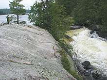
There are a lot of falls in the park. Louisa Falls is one of the more common destinations for the southern part of the park.
McAree Lake is the most convenient of the four entry points accessible from Lac La Croix. From here, it is only 5 km to Quetico’s interior. Beyond is some of the most beautiful scenery in the Quetico-Superior region. Argo and Crooked Lakes, Curtain Falls, the Siobhan and Darkwater rivers and the pictographs of Darkwater Lake are among the not-too-distant attractions.
Do
Swimming, hiking, wildlife viewing, fishing, canoeing, kayaking, and picnicking at one of the day-use areas are available at the campgrounds during the summer. The winter months offer groomed cross-country ski trails, snowshoeing and ice-fishing.
Buy
A small Park Store selling Quetico souvenirs can be found at each entry station, and at the Dawson Trail Heritage Pavilion.
Eat and drink
Bring food and drinking water with you from Atikokan or Thunder Bay.
Can-op Quetico Restaurant, Gas & Convenience Store is on the Trans-Canada Highway 5 km west of Dawson Trail.
Sleep
Lodging
- Rustic cabins. Check-in: 3PM, check-out: 11AM. Quetico offers three rustic cabins with kitchens and drinking water (but not utensils, plates, pots). Each cabin sleeps 4 people: the Log Cabin at Dawson Trail Campground, and the Art Studio Winter Retreat (open Oct-Apr) and the Ojibway Cabin at Ojibway Campground. Ski and snowshoe or swim and canoe from your front door. An outhouse toilet is nearby. Shower facilities (comfort stations open throughout summer months). No pets or smoking in the cabins.
Camping
- Dawson Trail Campground (on French Lake in the northeast corner of the park), ☎ +1 519-826-5290 (outside of Canada & U.S.), toll-free: +1-888-668-7275. There are over 100 campsites are in two campground loops: Chippewa and Ojibwa, both on Dawson Trail Road. There are 35 km of hiking trails. Both campgrounds have electrical campsites and can accommodate trailers and tents. Vault toilets, flush toilets, showers, laundry and water taps are all nearby. Many campsites are lakefront with direct access to water. Open mid-May to early October. 2018 rates per night per camping site: $41-51 for electrical sites ($33-41 for Ontario seniors, $21-26 for Ontarians with disabilities; $36-45 for non-electrical sites ($29-36 for Ontario seniors, $18-23 for Ontarians with disabilities).
Backcountry
Quetico is known for its wilderness canoeing. If you plan on going, you need a canoe. The majority of the park is only accessible by a canoe. The backcountry has over 2000 primitive camping spots in some of the most beautiful scenic views in the area. You are limited to a maximum of 9 people in your group and no more than 4 canoes. Since the majority of the park is primitive, you have to plan accordingly. Everything you take in has to be packed out.
There are six access points into the park where you can obtain permits for the backcountry: Cache Bay and Prairie Portage ranger stations for those entering from the United States in Minnesota, Dawson Trail Ranger Station and Atikokan Ranger Station accessible by car in Canada and finally, the Lac La Croix and Beaverhouse stations. For those entering Canada from the United States, you must obtain a Remote Area Board Crossing permit from Canadian immigration or by mail.
Stay safe
As Quetico is a wilderness park there are restrictions that users must be aware of. Group size may not exceed 9 members. Containers of fuel, insect repellent, medicines, personal toilet articles, and other items that are not food or beverage are the only cans or bottles that may be brought into Quetico. It is an offence to possess non-burnable and non-reusable food or beverage containers. Mechanized devices such as power saws, generators, ice augers, or portage wheels are prohibited. It is furthermore illegal to damage live trees and other plants.
Fishing regulations regulations state that only barbless hooks and artificial bait are permitted in the park. "This means that no live or dead organic bait can be used in the park, including but not limited to leeches, worms, and salted minnows." Barbed hooks may be in a tackle box but must not be on the fishing line. Barbed hooks must be pinched before being attached to a fishing line. It is recommended that park users only use lead-free tackle when fishing within the park.
Hunting or molesting wildlife or possession of a firearm or fireworks is not allowed.
Go next
- Adjacent the southwest corner of Quetico is the Anishinabe community of Lac La Croix. The lac La Croix Park Entry Station is here. This small community hosts a traditional Pow Wow and other public events throughout the summer.