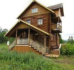
Nalychevo Nature Park
Nalychevo Nature Park is in the Kamchatka peninsula in the Russian Far East.

Understand
Established in 1995 the park covers 287,000 hectares of the Nalychev river valley which borders two chains of mountains and volcanos. The territory comprises a host of sources of hot and cold mineral water qualified for medical cure. The rich variety of plants and animals, many of them in the Red Book, provided the Park to become a UNESCO Heritage object.
History
The valley was used by local population from long time ago. In the middle of the 19th century Carl von Ditmar discovered a multitude of debris of abandoned native huts. Till 1952 there was a settlement here.
In 1929 scientists found out the medical qualities of the water.
On 18 August 1995 the governor of Kamchatka issued an order for organization of the park, supported by 1130 signatures of Kamchatka people. Experts of UNESCO agreed on status of Nature Park on 6 December 1996.
Landscape
Flora and fauna
Climate
Get in
You'll need an automobile connection to the village Pinachevo 20 km away from Yelizovo or 25 km away from Petropavlovsk-Kamchatsky. The hiking trail is 40-km-long and takes 2-3 days.
The other option is helicopter that will fly you to the center of the Park.
Fees and permits
Get around
Getting out of the Arc the trail runs on the hilly terrain and crosses small rivers and springs covered with shilly-shally bridges. At the 18th km there is the Semenovsky Camp with a house for 15 persons to stay overnight and a shelter to prepare food. But know that you may be not the only tourists there. Further on the road climbs onto the Pinachevo Pass (1160 km) and descends in the birch forest on the plain. Each 15 km the route is marked with a sign post showing air-line distance. There are also places for fire-camps along the trail.
See
Do
Buy
Eat
Drink
Sleep
Lodging
Camping
Backcountry
Stay safe
Go next