Landmannalaugar
Understand
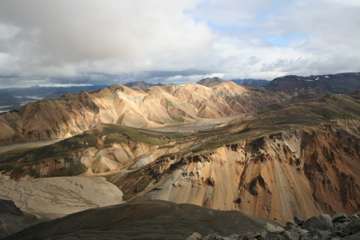
A remote encampment consisting of a campsite, and accommodation hut as well as basic amenity huts including an excellent shower block and a small shop. The camp is surrounded by mountains and is backed by a massive rhyolite (volcanic rock) cliff which shelters it (although it is still very exposed - take heed of the piles of rocks for anchoring tents that are kept in large wooden boxes or "rock corrals"). Many volcanic phenomena can be seen in the area. Landmannalaugar is part of the Fjallabak Nature Reserve.
Get in
In summer, from about late June, there is a daily bus service from Reykjavík which lasts several hours but takes you through some of the most stunning landscapes you are likely to encounter in a bus. You start off in the coastal lowlands but quickly move to dirt roads and eventually barely discernible tracks across the pitted lava and ash plains in the shadow of Hekla, one of Icelands more active volcanoes. In high season (July and August), bus services are also available to/from Akureyri, Myvatn and Skaftafell.
You can also attempt to reach Landmannalaugar by sturdy car, although a 4x4 is strongly advised (check your hire car insurance - it may specifically exclude the "highlands" of the interior). There are three roads to Landmannalaugar. The most easily passable road is from the north, via the paved road to Hrauneyjar, and passes through desert scenery typical of the deep interior. The road from the west has several fords which may be passable in an ordinary car depending upon the water level. The road from the east is the roughest and has the most fords. There is a deep ford immediately before the Landmannalaugar site which is not normally crossable in an ordinary car, but you can park before it and arrive on foot.
Landmannalaugar is only accessible in summer. The dates that the roads open vary from year to year. Typically the road from the north opens earliest, sometimes as early as late May, more usually by mid-June. The western approach usually opens in June, and the eastern approach usually by the end of June. The roads usually remain open through September, and road access may finally be lost any time from late September to early November.
Get around
The landscape is fairly rough, so four-wheel drive and high-clearance is a must.
See

The star attraction is the hot spring which runs right past the campsite. It can get busy at peak times so an early morning visit just after sun up is highly recommended. Don't miss the steaming sulphur pots in the hills behind the camp but watch out for the stench, it can be quite overpowering.
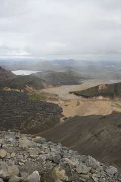
Hiking the nearby mountains is essential. A quick jaunt up the steep peak Bláhnúkur takes a few hours, but offers stunning views of the surrounding mountains in their distinctive orange and green hues. A long day walk might take in the ice-caves at Hrafntinnusker, a few hours along the marked Laugurvegurinn trail.
The weather at Landmannalaugur is frequently poor, with persistent light rain and low cloud, or worse, blocking views. Fortunately Icelandic weather is generally changeable, and when the sun does come out, the views are unmatched.
Do
Plenty of trails criss-cross the region, but only a few of these are marked or visible on the ground. In particular, this is the starting (or ending, depending on your direction of travel) point of Laugavegurinn, the Landmannalaugar - Þórsmörk trail - a demanding 2-4 day hike with huts and campsites on route. It can also be extended by 1-2 days by continuing to Skógar.
Laugavegurinn is by far the most famous and most walked hiking trail in the country, regularly listed as one of the top hiking trails on the planet. As a result, demand for use of the huts is high, and in high season they should be booked many months in advance. The alternative is to camp, which is not subject to reservation. You should bring food with you since, aside from a small and very expensive shop present at Landmannalaugar during high season, there is no opportunity to buy food on the route, neither at the huts nor at Þórsmörk. You should also be prepared for unpleasant weather - low temperatures, high winds, heavy rain, occasionally some snow, even in summer.
Laugavegurinn is regularly marked with clearly visible marker sticks every 200m or so. Further, during high season (end June to late August), it is heavily walked, so there is little risk of getting lost. In the early part of the high season, some parts of the trail are likely still to have snow cover, which may make navigation more difficult, and presents risks of falling through snow bridges.
Outside high season, the amount of snow cover is increased, and the number of walkers greatly reduced. This increases the difficulty of navigation, and also the risk that you will not be discovered if you get into difficulties. There is no GSM coverage in the area. A small number of off-season hikers have died of hypothermia as a result of such incidents. Off-season hikers should also take account of the period during which there is road access to Landmannalaugar.
Horseback riding is also available, for shorter or longer rides. The horse riding trips visit places which can often be difficult to access on foot and are not accessible by car as there are no official roads, as an example into Jökulgil (Glacier Valley). No reservations are needed. The horse rental is open from 1st July.
Buy
The mountain hut may have some information leaflets available for sale. Aside from this, there is nothing available to buy at Landmannalaugar, except at the small food-store mentioned below.
Eat
In high season, there is a "Mountain Supermarket", a converted schoolbus, which doubles as a cafe and a small food store, with very high prices. Occasionally locally caught fresh fish, usually Arctic Charr, is available for sale. Make sure you take enough food with you in case this is closed or out of stock!
Drink
It's advised to drink plenty of fluids whenever hiking or on an outdoor trip. Making sure you're hydrated is essential to enjoying your trip! The streams you find are generally safe to drink. Take a look at the rocks in the riverbed, if they are colored more strongly red/orange/yellow than the riverbank there are probably some sediments in the water so it might taste a little weird. Still, you can generally assume that the water is safe to drink. There is plenty of water around, except on a 5-6 km stretch just north of Þórsmörk. Most people will get away with carrying a 1 L bottle and refilling it whenever possible.
Sleep
The mountain huts are operated by Ferðafélag Íslands, The Iceland Touring Association, and it is advised to book well in advance in high season. Otherwise camping is unreserved.
