Jurmo
Jurmo is an island in the southern part of the Archipelago Sea, in the outer archipelago, with rich bird life and special nature. It is the furthest off-coast island in the Archipelago Sea you can explore within a day trip from the mainland with a ferry.
Understand

Jurmo is a remote barren island with special nature, regarded as a "must" for those boating in the outer archipelago between Nagu and Utö. The island has a chapel due to the remoteness, although traditionally inhabited by only four families (down to one person living there alone in the 1980s). Most of the island belongs to strict nature reserves or to the Archipelago Sea National Park, the latter providing some services, in addition to those of the locals.
According to a popular story, back in the 1500s the villagers lured passing cargo ships to run aground by lighting bonfires and then robbing the cargo from the shipwreck. When king Gustav I of Sweden heard about this he ordered the whole island and its residents to be burned down. Legend or not, such fire would actually explain the lack of woods and top soil on the island.
The island had no safe harbour until modern times, so more than once most boats were destroyed when the villagers did not manage to move them around the island in time. On the other hand the storms also quite often brought goods from shipwrecks – with or without bonfires. At least one rescued seaman stayed on the island long enough to marry here, and to make the votive ship in the chapel.
Nature
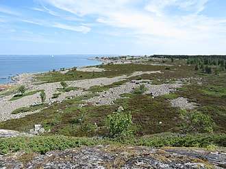
The island is geologically part of Salpausselkä, the terminal moraine system separating the Finnish Lakeland from the Gulf of Finland. This makes the landscape very different from the rest of the archipelago. The shores look like sandy beaches from a distance, only that the "sand" is such only for giants. Walking on the shores is surprisingly heavy as the round pebbles move under your feet.
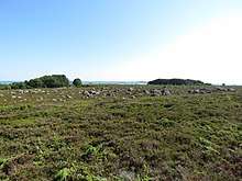
Jurmo is a fairly flat island and almost completely covered by a treeless heath, the heather and juniper being the most visible species. The juniper grows mostly horizontally here, just like on the fells in northernmost Lapland. In the southeast part of the island there is a small but very lush forest where European alder is the main tree. As the next strip of land south from Jurmo is actually Poland the storms are usually severe here. In the 1930s, a pine forest was planted south of the village to protect the village from strong south winds.
Get in
The ferry m/s Eivor from Pärnäs, in Nagu, to Utö, calls at the island and is free of charge. You can find the timetables online. The arrivals and departures highlighted in yellow have a coach connection from/to Turku. The ferry will wait for the coach in Pärnäs.
A day trip to Jurmo is possible during summer months on Mondays, Tuesdays, and Wednesdays but there is no connection back to Turku on Wednesdays (when the return is later). The coach leaves Turku bus station at 06:45 and tickets cost €13,70/adult. You will have 2½ hours to explore the island, which you will probably find to be a very short time. For pedestrians that time will be enough to reach the village and see the views from Högberget but to reach the munkringar you probably wish to ride a bike. The departure time is an estimate, don't gamble on it. Other days the ferry arrives late and departs early, so you probably want to stay two nights.
You could use a taxi boat, but the distance makes such trips expensive. Tours for groups are arranged from Nagu and Kasnäs.
For those with own or chartered yacht there is a large guest harbour with limited service. Jurmo is in the outer archipelago, so if you are coming by yacht, and especially if you are coming with a smaller boat, you should check the maritime weather forecasts.
- m/s Eivor, ☏ +358 44-500-0503. Year round, more or less daily. From Pärnäs via a few other islands. Coach stop and parking in Pärnäs. Some food and drinks served on board. Hint: If you want to eat their lunch, mention that you are leaving at Jurmo. They probably can prepare your meal a little bit in advance so you'll have more time to eat. Free, lunch €12.
- 🌍 The harbour. Large harbour with good breakwaters and limited service. This is where you arrive with ferry or yacht.
Get around

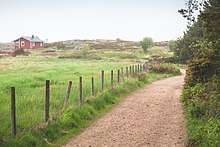
Walk. You may be able to get transport by ATV, at least for your luggage if you are staying in the village. A bike may be useful for getting between the harbour and the village. Otherwise you will walk. The island is 6 kilometres (4 mi) from end to end, although the ends are just long reefs. There are trails, use them where reasonable, to avoid erosion.
Distance between the harbor and the chapel is 1.4 kilometers. The nearest Munkring is 700 meters from the chapel.
The western part of the island is off limits during bird nesting time, i.e. from April 1st until July 31th. Check rules for the nature reserves, probably venturing off trails is disallowed in them. They cover most of the heath and some minor other areas.
See

Traditionally there were three landmarks: the hill (🌍 Högberget), 🌍 the wood, and the tree, a lonely pine which unfortunately died during an autumn storm in 2001. That is not all there is to see, though.
Being one of the outermost islands on the Baltic Sea, Jurmo is a remarkable resting place for migrating birds. Over 300 species have been observed here! Try to spot some. Jurmo is also home to some very rare plants.
There are two guides among the locals:
- Aino Mattsson, ☏ +358 2 4647 137
- Agneta Andersson, ☏ +358 2 4647 166
Sights
- 🌍 Nature hut (by the harbour). always open. An exhibition by the national park. Vast amount of information about the odd nature and rare species on the island. Also some history. No staff. Maintained by Metsähalllitus/Forststyrelsen, the Finnish Forest Administration. Free.
- 🌍 The chapel. The current chapel is from 1846. The votive ship was made by a shipwrecked sailor. Until 1960s the graveyard was used also to bury deceased from "neighbouring" Utö.
- The alpacas and cows. There is small group of alpacas wandering freely in the village. A herd of cows is grazing in the eastern part of the island. To keep the animals where they should be, always close any gate you open.
- 🌍 The beaches. Beaches with cobblestone posing as sand. The one between the harbor and Högberget is most popular.
- 🌍 Old windmill. Old windmill in the village.
Archaelogical findings

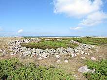
- 🌍 Munkringar. The Munkringar (Swedish for "monk rings") are four stone circles in the eastern part of the island. It isn't known who made these circles, when they were made and why. They resemble tomtnings which are known from elsewhere by the Baltic Sea and assumed to be foundations for temporary dwellings... except that tomtnings are always rectangular while these munkrings are circular. These remains are completely unique. The four circles are located about 200 meters apart from each other by the northern shore of the island.
- 🌍 Very old chapel ruins. About 250 meters east from the easternmost Munkring there is a rectangular stone structure surrounding another, smaller rectangular stone structure. This remnant is believed to be the first chapel on the island, but no one knows it for sure.
Do

Walk around, admire the landscapes and contemplate the tough life of yore.
The island is a good place for bird watching, during the migration in spring and autumn one of the best in the Archipelago Sea. There is an ornithological station maintained by the Ornithological Society of Turku.
Buy
There may be fish or handicraft for sale in the harbour.
Eat and drink
There is a café and a tiny grocery store in the harbour, open in summer. Ask for their freshly smoked fish! If you rent a cottage, check whether meals can be arranged or whether you have to use the cottage kitchen. If you are camping, have a camping stove.
Drinking water is available only from the 🌍 well with hand pump in the harbor or from a tap at the pier in the harbor. The well in the village is locked. Another option is to buy some from the store.
- 🌍 Café and grocery store.
- 🌍 Jurmo Inn, ☏ +358 40-172-1665, ✉ jurmoinn@jurmoinn.fi. lunch 12-18, à la carte 18-21. Lunch daily in July, otherwise by request. À la carte in the evenings. Breakfast available by request. Contact preferably by SMS or e-mail.
Sleep
There is a water point, 🌍 dry toilets and a recycling point in the harbour.
Jurmo Inn (see above) has three rooms for accommodation. During the season they will be fully booked well in advance.
Camping
- 🌍 Moringharu camping site (by the harbour bay, opposite to the quay). Camping site of the national park and the only place where you are allowed to pitch your tent. Moringharu is a rocky islet connected to the main island by a narrow isthmus. The terrain is rocky but there are many patches of soft, flat ground large enough for a tent. You are free to select any place. Campfire site with firewood but no other services. Moringharu is about 900 meters by feet from the harbour (and thus from the toilets as well).
Cottages
- 🌍 Norrgrannas, Jurmo byväg 152, ☏ +358 400-424-261, ✉ jurmo@jurmo.com. Cottages in the village. Sauna and WC. €55–95/night for 2–7 persons, depending on cottage.
Stay safe
Jurmo is definitely a summer destination so for most visitors summer by the sea safety instructions apply. Beware of sunburns. Jurmo is mostly treeless so there is very little shelter available from the sun and the wind. Especially when camping, your tent might get quite hot during a sunny day (and the day starts early in the Nordic summer).
Make sure you have sufficient water resources. There is no drinking water available after you left the harbor. Sea water is too salty to drink this far off coast (only 0.5%, but it still tastes undrinkable).
There are ticks like elsewhere in the archipelago. Both Borreliosis and TBE are nasty, so do your checks.
Do not irritate those cows and make sure you close every gate you open.
Connect

Go next
- Utö, even farther out, with a lighthouse, pilot station and a little more inhabitants (the first relocated there from Jurmo by the crown, as pilots).
- Örö off Kimitoön, accessible by tour boat via Aspö (check!) as well as via Kasnäs.
- Bengtskär, if Jurmo is not barren enough for you: a cliff with a lighthouse, among the last islets towards the Gulf of Finland.