Huanglongsi National Park
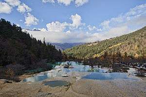
Huanglong (黄龙) is a mountain with natural mineral pools and lakes forming on it. It is in the northern part of Sichuan province near Jiuzhaigou in China.

Understand
Huanglongsi National Park is a component of Huanglongsi-Jiuzhaigou National Park.
History
Landscape
Huanglong is a mountain that is relatively easy to climb, and the mountain is covered with trees and plants and also many mineral pools and small water falls.
Flora and fauna
There is many types of plants and trees on the mountain, some are rare and may be endangered so take time to enjoy and see it! Animal life is of course existent but the chance of seeing one going up the mountain is very slim (except you might see a few squirrels).
Climate
The weather at the bottom of the mountain is similar to the surrounding areas, although the weather on the mountain can be cool in the summer and cold in the winter. Bring a sweater.
Get in
Buses leave regularly from Chengdu so that will be your best bet.
A bus leaves Jiuzhaigou Bus Station at 07:00 (takes 3-4 hours, ¥40) The same bus returns to Jiuzhaigou at 15:00, and is the only public way to go out.
You can hire a taxi for the Jiuzhaigou-Huanglong roundtrip or the Jiuzhaigou-Huanglong-JZH airport trip for ¥400. The most efficient way to visit Huang Long is to do it on the last day of your Jiuzhaigou visit and return to the airport directly. If you do this by private car, with a 07:30 departure from Jiuzhaigou you will be able to enjoy the park completely and get to the airport by 17:30.
Fees and permits
- ¥200 per person (1 Apr-15 Nov),
- ¥60 per person (16 Nov- 31March).
The price does not include a ticket for the cable car, which must be bought separately and costs ¥80 for a one way trip either up or down; most people use it to go up, but if you then decide to go down on the cable car it will cost a further ¥40.
Discounted tickets at ¥100 are available for students with ID and seniors over 60 years of age with proof of age (as of July 2013).
Get around
There is a moderately steep (average 10% incline) 4.2-km wooden boardwalk up the valley from the entrance to the colourful limestone pools and temple at the apex of the path. Some alternative trails are available for the return walk down the valley. This round trip generally takes around 4 hours, but schedule at least 6 if you want to do it really comfortably.
During the peak season (Apr-Nov) a cable car operates which takes visitors from near the entrance up to a high elevation equal to the highest points of the path. This then leaves a flat walk along the side of valley for several kilometres where it joins the main walking trails at the apex of limestone pools and temple. One can then walk down the boardwalk instead of taking the cable car back, and enjoy the forest, limestone formation and waterfall views on the way back to the entrance
See
The mineral pools and lakes are very fascinating as they are very colorful and pretty. Some small waterfalls that are almost horizontal. There is also a temple on the top of the mountain so check that out.
Do
Take pictures! The sceneries are beautiful and photographers will enjoy it. There is a temple on the top of the mountain so you can go and check that out. Most of the time just take time climb the mountain and enjoy the beautiful scenery.
Buy
There is not much to buy except food and water.
Eat
There is small shops along the mountain paths and on top of the mountain. The food and the water are expensive so be sure to bring some of your own.
Drink
Bring your own drink as the price of water and beverages increase dramatically as you ascend.
Sleep
Huanglong is intended to be climbed up and down in a single day so there is no lodging on the mountain.
Camping
There is no camping.
Stay safe
Use common sense, if something seems dangerous, don't do it. Watch your step as you climb and remember that: If you climb don't look at the sceneries, if you look at the sceneries don't climb!
Also note the high altitude. The park entrance is about 10,000 ft (3,000 m) above sea level and the Five Colored Pool is nearly 12,000 ft (3,700 m) above sea level. Since the air is thinner, pace yourself as you make the hike up.