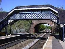
Hagley
Understand
The name Hagley refers to the area of the original village, near Hagley Hall. The majority of what is today known as Hagley is strictly West Hagley. This area grew up in the late 19th century near the railway station and contains the shopping area and schools. The precise dividing line between the two areas is undefined and is therefore debatable. Nevertheless, both settlements lie within the parish of Hagley.
Hagley is essentially a dormitory village. The population of Hagley greatly increased after the arrival of the railway in 1862, which enabled people to commute into Birmingham or the adjacent Black Country.
Get in
🌍 Hagley station is served on the Kidderminster to Birmingham line.
It is situated on the A456 Birmingham to Kidderminster road, which is known as the Hagley Road in Birmingham, because it was once administered by a turnpike trust, whose responsibilities ended at the former boundary of the parish (now in Blakedown).
Get around
See
- 🌍 Hagley Hall. the home for several centuries of the Lyttelton family, whose head is Viscount Cobham.
- 🌍 Wychbury Hill. with its 'monument' (an obelisk). The body of "Bella" was believed to be found in a wood near the hill, sparking the murder mystery "Who put Bella in the Witch Elm?" about which a play was written by the local drama society. However contrary to the urban myth the body was found in Hagley Wood off a lane on the side of nearby Clent Hill.
- St. Saviour's Church. a stone-built church near the centre of West Hagley, dedicated in 1908 and consecrated in 1957. The church consists of a nave and chancel without a tower.It has a series of windows by Francis Skeat.
Do
- 🌍 Clent Hills. popular hillwalking hill in the range
Buy
Eat
Drink
Sleep
- 🌍 Premier Inn Hagley, Birmingham Rd, DY9 9JS, ☎ +44 871 527 8484.
