Great Escarpment (Angola)
Understand

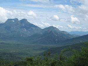
The Great Escarpment's northermnost reaches extend into Angola, but it is an enormous geographic feature throughout the whole of Southern Africa. It ranges southwards through Namibia, cuts through South Africa, and then extends north along the border of Mozambique and Zimbabwe. It surrounds the Central Southern African Plateau (sitting at over 2,000 m above sea level), with steep mountains descending towards Angola's coastal regions.
History
The Escarpment is old, having formed along with the formation of the Atlantic Ocean some 160 million years ago. The steep mountains you see today have been shaped by the gradual rising of the plateau over the past 20 million years, and the very slow accompanying process of erosion from coastal winds.
Landscape
The Escarpment is the zone right between Angola's central plateau (which includes Lubango), home to the country's savanna landscapes, and the steep mountains and hills descending towards the flat coastal regions. The immediate mountainous drop from the plateau is steepest in this region, with the Serra da Chela mountains being the country's steepest and most dramatic. The highest point in Angola, however, is Mount Moco, in the Huambo Province.
Flora and fauna

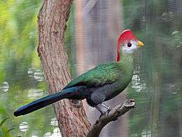
The mountain regions are rocky, with patches of dry woodlands. The low forest was once home to elephants, lions, and cheetahs, but as with most of the Angolan wild, these were hunted and poached into oblivion during the 30 year civil war. The largest species remaining are small antelopes known as duikers, with nocturnal tree pangolins being another interesting one to try and spot (good luck). Of the many birds endemic to Angola, this region's most unusual and beautiful is the red-crested turaco, which is quite common in this region, and is the national bird.
Climate
As with most of Southwest Angola, the climate is relatively dry, though not nearly as arid as the Namib desert.
Get in
You will need your own 4x4 vehicle to drive here from Lubango or Namibe, or you will need to go with a tour agency.
See
The mountain ranges of most interest to 4x4 travelers are the Serra da Chela and the Serra da Leba. The Tundavala Gap in the latter is where you'll find one of the most beautiful views in the whole country.
The 🌍 Serra da Chela is a beautiful but fairly inaccessible mountain range in the Great Escarpment. The easiest way to get into these mountains is from Lubango or Namibe, on the road between Capangombe to Humpata.
The 🌍 Serra da Leba is also near Lubango, with opportunities for hiking, and including the really spectacular 🌍 Tundavala Gap.
Do
4x4 drives and hiking are really all there is to do, and you're on your own!
Buy
Eat & drink
There may be roadside street vendors near the villages on either side of the mountains.
Sleep
As with much of Angola, there are not tourist facilities of any kind in these mountains. You can daytrip from Lubango and Namibe, or try your hand at wilderness camping.
Stay safe
Certainly don't go alone. If you are, say, hiking, and get hurt, you could die. There will be no one to help you get back to town, and the nearest reputable medical facilities are in South Africa.
Go next
Presumably any visitors here are interested in the wilderness areas of Angola. The most obvious other backcountry sights in this part of the country lie to the west and south of Namibe in the desert.