Great Eastern Highway
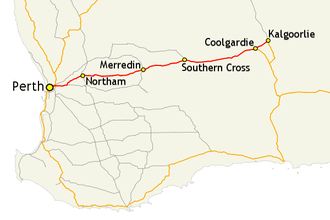
The Great Eastern Highway is in Western Australia and runs from Perth to Kalgoorlie in the eastern goldfields.
- This article is an itinerary.
Understand

Great Eastern Highway is a 590-kilometre-long (370 mi) road linking the Western Australian capital of Perth with the city of Kalgoorlie. A key route for vehicles accessing the eastern Wheatbelt and the Goldfields, it is the western portion of the main road link between Perth and the eastern states of Australia. Many people commute along this highway, and the traffic is quite heavy in certain parts, however the stopping places and locations near this highway make the journey a real adventure. It is intimately linked with the old railway that used to go to Kalgoorlie, as well as the well marked Golden Pipeline set of locations that follow the water pipeline to Kalgoorlie.
Prepare
Although not as isolated as other Western Australian country highways, services are limited between Merredin and Southern Cross, and Southern Cross and Coolgardie. It is worth having extra water and being prepared for issues.
If travelling with children, the Merredin to Coolgardie stretch has monotonous landscape and limited facilities, so being well stocked with entertainment or spare drinks and food is well worth preparing for.
Sunrise and sunset on the more isolated stretches are prone to have wildlife close to the road, having headlights on is one thing, but it is better to travel outside of these times. Emus and Kangaroos will come to road drains to drink after any rainfall, specially at those times.
Get in
The end points of the highway are in Perth and Kalgoorlie. From the western end in Perth, the highway can be accessed from numerous intersections with other highways and main roads – including Canning, Albany, Tonkin and Roe Highways, and Graham Farmer Freeway – as well as numerous arterial roads and suburban streets. From Kalgoorlie at the other end of the highway, it continues west from Hannan Street, the city's main east–west road.
There are also two rural highways that connect to the highway: Coolgardie–Esperance Highway terminates at Great Eastern Highway in Coolgardie, 40 km (25 mi) west of Kalgoorlie, bringing along interstate traffic from South Australia. Great Southern Highway, one of the highway routes from Albany, ends at Great Eastern Highway at The Lakes, a locality on Perth's eastern fringe. Other road connections are possible, generally at the towns on the highway.
If travelling from the eastern states of Australia, access to the highway is via Eyre Highway, west from state border to Norseman, and then north along Coolgardie–Esperance Highway, from Norseman to Coolgardie.
Drive
- Clackline
- Northam
- Meckering
- Cunderdin
- Tammin
- Kellerberrin
- Merredin
- Westonia
- Southern Cross
- Coolgardie
Golden Pipeline Heritage Trail
The highway runs mostly parallel to the Mundaring to Kalgoorlie water pipeline, which supplies the Goldfields with water from Mundaring Weir in the eastern part of Perth. The Golden Pipeline Heritage Trail is a tourist drive alongside the pipeline, with large sections of the trail following Great Eastern Highway.
Break up the long journey to Kalgoorlie by following the white-on-brown pentagonal heritage trail markers, and stopping by the pumping stations and other historic sites along the way.
Stay safe
The highway has monotonous sections where drivers fall asleep at the wheel - be vigilant in your own wakefulness, as well as watching other vehicles movements and behaviour. Near the goldfields region there can be heavy traffic, large road trains and trucks must be considered a hazard. Never try to overtake large trucks on narrow roads.
Go next
- Return to Perth along the coastal route via Esperance and Albany
- Go north into goldfields
- At Coolgardie, turn south to Norseman, and then on to the Eyre Highway to travel across the Nullarbor to South Australia