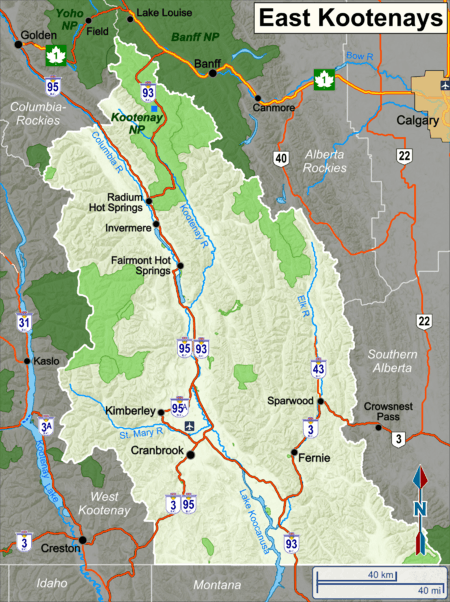
East Kootenays
The East Kootenays is a region in south-eastern British Columbia, generally taken to include the valley of the Columbia and Kootenay Rivers south of Golden to the USA border Canada. The valley is bordered to the east by the Rocky Mountains and to the west by the Purcell Mountains.

Cities and towns
- 🌍 Cranbrook - anchoring the south end of the East Kootenays and the largest city in this region with all the facilities travelers could need.
- 🌍 Fairmont Hot Springs
- 🌍 Fernie - renowned for great skiing and close enough to Calgary to be a weekend destination.
- 🌍 Invermere - a small community on the north end of Lake Windermere, popular as a summer and weekend destination when its population may increase dramatically with visitors from neighbouring Alberta.
- 🌍 Kimberley - the Barvarian-styled town just north of Cranbrook, a former mining town and excellent ski destination.
- 🌍 Radium Hot Springs
- 🌍 Sparwood
Other destinations
Understand
The East Kootenay valley is generally wider, drier and has greater extremes of temperatures than the West Kootenays, with which it is often compared. The valley is only a few hours drive from Calgary and other points in southern Alberta, and many people from those areas own property and/or visit during the summer for boating, fishing and golf and in the winter for skiing.
From Canal Flats, about 30 minutes north of Cranbrook, the Kootenay River enters the valley from the Rockies and flows south; the Columbia River starts its journey north from its headwaters in Columbia Lake.
Early in the 1900s, there was a plan to join the Columbia and Kootenay Rivers at Canal Flats, how that community got its name. Perhaps fortunately, that project did not succeed. Traces of the attempted canal are still visible.
Get in
The most common and convenient way into this area is by private vehicle. There is little in the way of scheduled public transportation.
Tour buses are numerous, bringing visitors to places like Radium Hot Springs.
Cranbrook has an airport with a limited number of scheduled airline connections, mainly Jazz Air and Pacific Coastal.
The smaller communities have landing strips for private airplanes.
The valley is accessed from the north at Golden from the Trans Canada Highway Rte 1, from the east through Kootenay National Park to Radium Hot Springs or, in the south, from southern Alberta on Rte 3 via Fernie. Highway 3 is the only east/west route in the south and links this valley to the West Kootenays starting at Creston, an hour west of Cranbrook.
Get around
See
Do
Eat
Drink
Stay safe
Go next