East Antarctica
East Antarctica is a region of Antarctica. Although the term is a bit counterintuitive for a continent straddling the South Pole as one could continue traveling eastward indefinitely on the continent, it refers to the region's location in the "eastern" hemisphere as defined by the Prime Meridian and the 180th meridian, thus the region nearest Australia.
Regions
- Adélie Land — The portion of Antarctica claimed by France, is home to the France Dumont d'Urville Station.
- Enderby Land — Most interesting for the Enderby Land Coast Range of mountains up to 2830 meters tall, readily viewable from the Indian Ocean. The Southern Pole of Inaccessibility is in Enderby Land.
- Mac. Robertson Land — Home to the Prince Charles Mountains, forming a ridge along some 260 miles
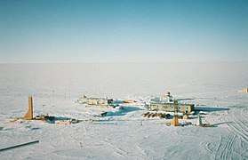
- Princess Elizabeth Land — Housing a cluster of old research stations, as well as current stations operated by Australia (Davis Station), Romania (Law-Racoviță Station) and Russia (Vostok Station, the coldest place on Earth)
- Queen Mary Land — Home of the Shackleton Ice Shelf
- Queen Maud Land — A huge swath of Antarctic coastline, most of it bounded by impressive ice cliffs, containing a long list of research stations, including two of claimant Norway's; the unending Antarctic Plateau in the south of the region includes the highest ice formations on the continent, including Dome Argus.
- Victoria Land — The land just west of the Ross Sea, with a good share of the beautiful and enormous Transantarctic Mountains.
- Wilkes Land — East of Victoria land is Wilkes Land, and you might be interested to know that Wilkes Land was the fictional setting for much of the X Files movie.
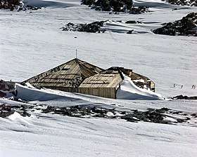
- George V Land — An area east of Adélie Land and is home to Mawson's Huts, in Commonwealth Bay.
Bases

- Dumont d'Urville — Research Station (France)
- Vostok — Antarctica's most isolated station, operated by Russia near the Southern Geomagnetic Pole; this is the main stop for expeditions crazy enough to try and reach the Southern Pole of Inaccessibility, and is the site of the lowest recorded temperature on Earth
Other destinations
- Cape Denison - Commonwealth Bay (Mawson's Hut)
- Mertz and Ninnis Glaciers
- Southern Pole of Inaccessibility
Understand

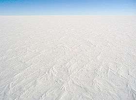
Like West Antarctica, East Antarctica is extremely remote. But the east's location almost completely on the high Antarctic Plateau makes it probably even more remote than the west.
The only well-known point of interest in East Antarctica is Vostok, which has the reputation of extremely cold weather. Underneath Vostok station there is an underwater lake that would be in the top ten by surface area and water volume if it were on the surface. Little is known about this lake and whether its waters are connected to other bodies of water on Antarctica or the surface and there are plans to take sample to analyze whatever lies down there.
Get in
The Antarctic Company operates 3 day excursions from Cape Town to Schirmacher Oasis in Queen Maud Land, East Antarctica.
Get around
See

- 🌍 Dome Argus (Dome A). Antarctica's highest ice formation, located in Queen Maud Land on the Antarctic Plateau. Given its height, extreme continental climate, and proximity to both the South Pole and the Vostok Research Station (where the coldest temperature on Earth was recorded), its peak is suspected to be the coldest place in the world.
- 🌍 Isachsen Mountain. The highest mountain of the East Antarctica Ranges, near the coast of Queen Maud Land.
- 🌍 Mawson's Huts. Built during the Australasian Antarctic Expedition in 1912. It is one of few surviving structures from the early exploration of Antarctica. The huts have been managed by a preservation foundation since 1997.
- 🌍 Mount Kirkpatrick. Best climbed in April. The highest of Antarctica's mountains is terribly hard to reach, but is climbable on extremely expensive expeditions. 4528m.
- 🌍 Shackleton Ice Shelf.
- 🌍 Vostok Research Station.
Of interest to explorers and adventurers is the pole of inaccessibility marking the furthest point from any easily-reached geographic feature. The Southern pole of inaccessibility is the furthest point in Antarctica from any coastline, although the exact location is disputed due to the difficulty in defining Antarctica's coastline—whether to consider the "solid" coastline where rock/soil reaches sea level or factor in the massive, but ever-changing ice sheets. A modern calculation puts its location at 85°50′S 65°47′E. The British Antarctic Survey has calculated its position as 82°53′14″S 55°4′30″E when accounting only for the Antarctic land surface proper or at 83°50′37″S 65°43′30″E when ice sheets are taken into account. The Soviet Union built the Pole of Inaccessibility station at 82°06′S 54°58′E, 878 km (546 mi) from the geographical South Pole, and at an elevation of 3,800 m (12,467 ft). However, the station was only occupied from 14–26 December 1958 before it was suspended indefinitely because of safety concerns that it was too far from other Soviet stations. While the Soviets planned to use the station afterwards for short visits, only a handful of people ever since have visited the site, which is now buried by snow except for a bust of Vladimir Lenin perched atop its roof. The Soviet station and other calculated coordinates for the pole of accessibility are all unremarkable and, as the name suggests, difficult to reach. Only the most extreme adventurers itching to cross "I've been to the most inaccessible corner of Antarctica" off their dream list are likely to be interested in visiting the pole of inaccessibility.