Diving in the United Kingdom
This article is intended to provide the already qualified Scuba diver with information which will help to plan dives in the waters of the United Kingdom, whether as a local resident or a visitor. Information is provided without prejudice, and is not guaranteed accurate or complete. Use it at your own risk.
Understand
General topography
Climate, weather and sea conditions
Marine ecology
Equipment
Although wet suits are used by many divers, and the coastal waters of the west coast are kept relatively warm for their latitude by the Gulf stream, dry suits are recommended for most sites.
Dive sites
The UK has a large number of dive sites, both inland and coastal, and many of these are wreck dives. The inland dives include a number of lakes, quarries and caves.
Marine dive sites
- Chesil Cove is a shoreline shoreline dive site in Dorset, England.
 Chesil Cove from West Cliff
Location: The most southerly part of the 18-mile (29 km) long Chesil Beach
Access: Shore dive
Most dives will not exceed 10 to 15m.
Topography: Beach shoreline
Ecology: South coast marine life, including nudibranch, dogfish, spider crabs, lobster, cuttle fish, pipefish and John Dory.
Features: Although there have been several shipwrecks in the cove, there is not much diveable wreckage near the shore
Special skills required: No special skills recommended, the site is popular for diver training. - The Eddystone, (also known as Eddystone Rocks) is an offshore rocky reef dive site in Cornwall
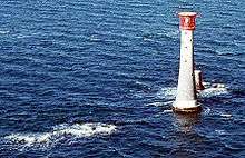 The Eddystone, with current lighthouse and stub of previous tower
Location: A seaswept group of rocks some 9 miles (14 kilometres) south west of Rame Head
Access: Day boat.
Topography: Gneissic outcrop of the Cornubian batholith supporting one of the world's iconic lighthouses.
Hazards: Can get very rough. - The Farne Islands is an offshore dive site in a group of islands off the coast of Northumberland, England
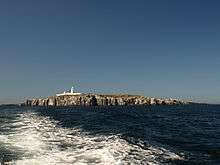 Inner Farne and its lighthouse.
Topography: There are between 15 and 20 islands and several tidal rocks from 2.5 to 7.5 km from the mainland, The main islands in the Inner Group are Inner Farne, Knoxes Reef and the East and West Wideopens, which are all connected at very low tide, and the Megstone a bit further away. The Outer Group, beyond Staple Sound, comprises Staple Island, the Brownsman, North and South Wamses, Big Harcar and the Longstone. The Farnes are Dolerite outcrops, which forms resistant columns, giving the islands their steep cliffs, and the stacks scattered around the sea around the islands. Many of the small islands are bare rock, but the larger islands have a layer of soil supporting vegetation. The strata slope slightly down to the north, so the highest cliffs are to the south and some beaches to the north.
Ecology: Birds and seals. Some sites may provide an opportunity to combine diving and bird watching — at the Pinnacles, Guillemots may be seen fishing at safety stop depth.
Features: Wrecks:
Wreck of the Danish steamer Chris Christenson, close to the reef off the south tip of Longstone, Outer Farnes in about 30-35m at N55°38.397' W001°36.182'
Wreck of the German SS Abessinia, at Knifestone, Outer Farnes, at N55°38.9' W001°36.12', in 9-20m of water.
Wreck of the British cargo and passenger steamer Brittania, on the Callers, Outer Farnes.
Wreck of the French steamship St Andre at Staple island.
Special skills required: There are sites suitable for all levels of diver.
It is usually possible to dive at the Farnes regardless of wind direction, as there is always shelter somewhere. - Fort Bovisand is a shoreline dive site in Bovisand harbour in Devon
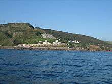 Fort Bovisand from the south
Location: A fort built at to defend the entrance of Plymouth Sound, at the narrows opposite the east end of Plymouth Breakwater.
Since mid 2008, Fort Bovisand has been the base of Discovery Divers - Hand Deeps is an offshore dive site in Cornwall
Location: an area of the English Channel 8 nm south-west of Rame Head
Access: Boat dive only
Directions: 3.5 nm north-west of the Eddystone.
Maximum depth at the site is 55 m and minimum depth is Top of pinnacles between 7 and 19 m.
Visibility is likely to be Frequent good visibility
Topography: The pinnacles are within a rectangle about 1 nm north-south and 0.5 nm west-east, and are shown on Admiralty Chart 1613. The central pinnacle rises from more than 40 m to 7 m.
Ecology: Anemone-covered walls make it a popular dive site.
It is named for a group of 5 pinnacles which rise from the seabed to between 7 and 19 m from the surface. - Hillsea Point Rock is a dive site
Location: a group of seven or eight pinnacles in the English Channel 0.5 nm south-east of Hillsea Point, Devon. see Admiralty Chart 1613
Access: Boat dive only
Maximum depth at the site is 25 m on the sea bed and minimum depth is 2 m depth at the top.
Topography: One of the pinnacles is split from top to bottom from north to south. The gap is narrow at the top, increasing to a 15 m long swim-through about 1 m wide at 23 m depth. - Holy Island is a dive site in an island on the western side of the larger Isle of Anglesey, North Wales
- The Manacles is an offshore rocky reef dive site in A group of rocks off The Lizard peninsula in Cornwall close to Porthoustock
 The Manacles (Carn-dhu and Maen Voes) looking south west towards Coverack
Location:
Directions: The rocks extend about 1 nm east and south east of Manacle Point
Topography: There are many submerged rocks and several groups of rocks that break the surface, although some are tidal. The Middle Manacles in the north consist of Maen Chynoweth or Morah, Chyronos, Maen Gerrick and the Gwinges, the eastern group has Vase Rock and Pen Vin, the large group in the centre include the Minstrel Rock, Carn-dhu, Maen Voes (the Voices) and the Quants and Maen Land is in the south-west.
Features: Many of the well-known wrecks are in the central group where depths are less than 6 metres over an area of about 300 m by 200 m. These wrecks include:
HMS Primrose, an 18-gun Cruizer class brig-sloop.
SS Mohegan
Greek steamer Spyridon Vagliano
The John, sank on the Maen Land.
A popular spot for diving due to the shipwrecks around them. The name is derived from the Cornish meyn eglos (church stones). - Martin's Haven is a dive site in A small bay in Pembrokeshire, Wales, on the Dale Peninsula.
Location:
Ecology: Grey Seals can be seen basking on the rocks.
Martin's Haven is in the Skomer Marine Nature Reserve and is popular for scuba diving. - Scapa Flow is a dive site in a body of water in the Orkney Islands, Scotland, United Kingdom, sheltered by the islands of Mainland, Graemsay, Burray, South Ronaldsay and Hoy.
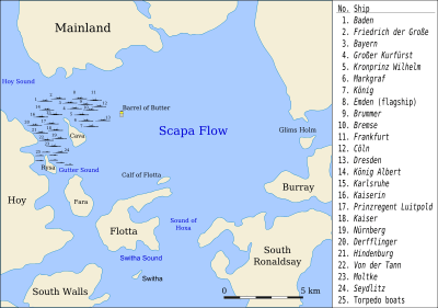 Map of the scuttled German ships at Scapa Flow
Location:
Access: As of 2010, at least twelve "live aboard" boats—mostly converted trawlers with bunk rooms in their former holds—take recreational divers out to the main sites, primarily from the main harbour at Stromness.
Maximum depth at the site is The wrecks are mostly at bottom depths of 35 to 50 m..
Visibility is likely to be very variable, from 2 to 20 m, and water temperature The water is cold
Topography: Scapa flow has an area of about 312 km2. It has a sand bottom with maximum depth of about 60 m, but mostly about 30 m, and is one of the great natural harbours of the world.
Features: There are very few sites which can offer such an abundance of large, historic wrecks lying in close proximity and shallow, relatively benign diving conditions. The wreckage of the remaining seven ships of the German fleet and some other sites such as the blockships is regularly listed in dive magazines and internet forums among the top dive sites in the UK, Europe, and even the world.
The wrecks include:
The three sister battleships of the König class, the SMS König, SMS Kronprinz and SMS Markgraf lie upside down with around 25m of water over them. They are impressive dives, because of their large size.
The four light cruisers SMS Dresden, SMS Karlsruhe, SMS Brummer, and SMS Cöln lie on their sides with around 16–20 metres of water over them. With the exception of the shallower Karlsruhe, they have been less heavily salvaged than the battleships and are much more accessible for divers.
Additional sites of interest include the destroyer V 83, which was raised and used as a working boat during salvage operations, and later abandoned; the Churchill blockships, such as the Tabarka, the Gobernador Bories, and the Doyle in Burra Sound; the U-boat UB 116; and the trawler James Barrie.
Hazards: It is possible to enter a wreck inadvertently in poor visibility and light. This could be disastrous if you can't find your way out again.
Recommended equipment: A surface marker buoy will provide a guideline to the surface in conditions of poor visibility, which mitigates the risk of getting lost inside a wreck after unintentionally entering in the dark.
Permits: Divers must first obtain a permit from the Island Harbour Authorities, which is available through diving shops and centres. Divers are permitted to enter the wrecks, but not to retrieve artefacts located within 100 metres of any wreck. However, broken pieces of ships' pottery and glass bottles have been washed into shallow waters and onto beaches.
The wrecks of HMS Royal Oak and the dreadnought HMS Vanguard, which exploded at anchor during the First World War, are war graves protected under the Protection of Military Remains Act 1986. Only divers of the British armed forces are permitted to visit them. Scapa Flow was the United Kingdom's main naval base during World War I and World War II, but was closed in 1956. - The Isles of Scilly is a dive site in an archipelago off the southwestern tip of the Cornish peninsula
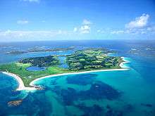 Looking across Tresco, one of the 5 inhabited islands of the Isles of Scilly
Location:
Directions: about 45 km off Land's End.
Topography: The archipelago consists of five inhabited islands and about 140 small rocky islets. They are all early Permian granite of the Cornubian batholith. - St. Abbs, (also known as historically known as Coldingham Shore) is a dive site in a small fishing village located on the south east coast of Scotland, in the Berwickshire area of Scottish Borders
Location:
Access: Shore diving to a depth of about 15 metres is possible from the rocks on the outside of the harbour wall.
Visibility is likely to be The sea around the village is unusually clear, in contrast to the more silt-laden coastal waters further to the north or south.
Features: The double archway at "Cathedral Rock" is just 50 metres from the shore.
Special skills required: This is a popular site for trainees to do initial sea dives.
These clear waters and the spectacular underwater scenery resulted in Britain's first Voluntary Marine Reserve being established at St. Abbs. Several small, nearby rocky islands, such as "Big Green Carr", "Broad Craig" and "Little Carr" are near to the harbour and easily can be circumnavigated underwater. - Swanage Pier is a dive site in at the southern end of Swanage Bay near Swanage, a small town in the south east of Dorset, England.
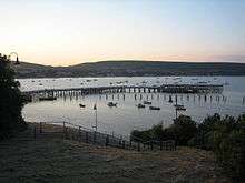 Swanage Pier at dusk
Location:
Access: Shore dive with easy access from adjacent car parks
Maximum depth at the site is About 5 m.
Ecology: Used for marine identification and underwater photography courses due to the wide range of marine life found under the pier.
Features: The Victorian pier is over 100 years old.
Special skills required: No special skills recommended. The pier is a popular training site for new and qualified divers.
One of the few sheltered sea diving sites on the south coast
Wreck sites
Wreck sites are plentiful and popular and include:
- HMS A1 is a wreck dive site
Location: at Bracklesham Bay
Features: Wreck of A-class submarine - HMS A3 is a wreck dive site in Dorset
Location: near Portland Bill
Features: Wreck of A-class submarine - SS Abessinia is a wreck dive site in the Farne Islands
Location: the Knivestone Rock in Farne Islands
Maximum depth at the site is 17 m.
Topography: The wreckage lies with a boiler clear of a jumble of wreckage - MV Aeolian Sky is a wreck dive site in Dorset
Location: 12 miles from Portland
Access: By boat from Swanage, Weymouth and Isle of Portland.
Directions: 5 miles south of St Aldhelm's Head
Most dives will not exceed 18 to 30 m.
Topography: The wreck lies on its port side in 30 metres of water with its bows facing south. The bows were blown off during salvage work, and are separate from the rest of the vesel.
Diver Magazine has produced a tour of the wreck. - Albert C. Field is a wreck dive site
Location: off St. Catherine's Point
Most dives will not exceed 30 to 34 m.
Topography: Gravel bottom.
Features: The wreck is broken up: The machinery is aft, with the boilers the highest point at 30 m depth, and the bridge forward with cargo space between. - HMS Boadicea (H65) is an offshore wreck dive site in Dorset
Location: 16 nm (26 km) south west of the Isle of Portland
Access: Boat dive.
Maximum depth at the site is 53m.
Features: The bows of the ship were blown off forward of the engine rooms. The stern section is upright and reasonably intact.
The wreck site is designated as a protected place under the Protection of Military Remains Act 1986 HMS Boadicea was a Royal Navy destroyer that was sunk on 13 June 1944 while supporting the invasion of Normandy. - SS Breda is a wreck dive site in Oban
Location: at the mouth of Loch Etive, just north of Oban.
Directions: The position is marked with buoys.
Most dives will not exceed about 26 m.
Dutch cargo-passenger ship sunk during World War II - SMS Dresden is a wreck dive site in Scapa Flow
_scuttled_17_June_1919.jpg) SMS Dresden in Scapa Flow
SMS Dresden in Scapa Flow
Location: to the south east of the island of Cava
Most dives will not exceed 27 to 38 m.
Features: Wreck of a Cöln class German light cruiser of World War II - SS Eastfield is a wreck dive site in Cornwall
Location: off Mevagissey
Maximum depth at the site is 50 m.
Features: The wreckage of a substantially intact 2,150 ton armed steamship, and the cargo of coal, which is scattered around the bottom nearby.
Recommended equipment: Equipment and breathing gas suitable for the depth.
Special skills required: Skills appropriate to the depth are required - HMS Elk is a wreck dive site in Devon
Location: off Plymouth
Most dives will not exceed 30 m (98 ft) of water with a drop-off in excess of 40 m (130 ft).
Topography: The wreck lies upright on a sandy bottom.
Features: Wreck of a 181 ton fishing trawler - HMS Falmouth is a wreck dive site
Location:
Most dives will not exceed 15 m.
Features: Wreck of a Town class light cruiser - HMS Ghurka is a wreck dive site in Kent
Location: off Dungeness
Most dives will not exceed 30 m.
Features: Wreck of a Tribal class destroyer
designated as a "protected place" under the Protection of Military Remains Act 1986. - Glen Strathallen is a wreck dive site in Devon
Location: south of the Plymouth break water
Topography: Broken up, but the boilers are still largely intact, and are a home for conger eels - Barque Herzogin Cecilie is a wreck dive site in south Devon
_-_SLV_H2009.45-753.jpg) Wreck of the Herzogin Cecilie
Wreck of the Herzogin Cecilie
Location: at Starhole (Starehole) Bay at the mouth of the Kingsbridge Estuary near Salcombe - SS Hispania is a wreck dive site in the northern part of the Sound of Mull
Location: facing the shore and close to a red channel buoy near Oban
Access: day boat
Most dives will not exceed 25 m.
Visibility is likely to be Water can be clear., and water temperature from 14°C in summer to as low as 5°C in winter
Topography: The wreck is substantially intact and upright. In 1999 a scallop dredger pulled down one of the masts and caused minor scrape damage. A scour pit on one side of the ship is causing the ship to slowly list into the depression.
Features: Wreck of 72 m Swedish steamer built in 1912 and sunk in 1954
Hazards: Strong tidal currents. The wreck can only be dived during slack water, about 1 to 2 hours before high or low water. In the summer the tentacles of migrating stinging jellyfish that pass over the wreck often get caught on the shot line and are dangerous to divers.
In November 2002 the wreck of the Hispania was purchased by the Puffin Dive Centre, Oban - HMS Hood is a wreck dive site in Portland harbour
.jpg) HMS Hood in the 1890s
HMS Hood in the 1890s
Location: scuttled in Portland harbour to block the Southern Ship Channel, a potential access route for U-boats or for torpedoes fired from outside of the harbour. The wreck is known as "Old Hole in the Wall"
Features: Wreck of a Royal Sovereign-class battleship - SS James Eagan Layne is a wreck dive site in Cornwall
Location: off Whitsand Bay, 540m east of the wreck of HMS Scylla
Maximum depth at the site is 22 m.
Features: Wreck of a World War II Liberty ship - SMS König is a wreck dive site in Scapa Flow
Location: The König is said to be between the Markgraf and Dresden and not where it is shown on the map.
Access: boat dive
Maximum depth at the site is 37m and minimum depth is 30m.
Topography: lying on port side, partly broken up.
Features: Wreck of a König class battleship of the German Imperial Navy - SMS Kronprinz Wilhelm is a wreck dive site in Scapa Flow
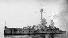 SMS Kronprinz Wilhelm in Scapa Flow 1919
Location:
Topography: Kronprinz Wilhelm was never raised for scrapping, unlike most of the other capital ships that were scuttled. The Kronprinz Wilhelm and two of her sisters ships sank in deeper water than the other capital ships, which made salvage more difficult.
Features: Wreck of a König class battleship of the German Imperial Navy
The vessels on the bottom of Scapa Flow are a popular dive site, and are protected by a policy barring divers from recovering items from the wrecks. - Kyarra is a wreck dive site in Swanage
Location: 1 mile off Anvil Point
Access: boat dive only
Maximum depth at the site is 31m and minimum depth is 25.
Ecology: Mussel beds adjacent to wreck
Hazards: Strong tidal currents, particularly at springs
Recommended equipment: DSMB recommended in case you can't ascend on the shotline
Special skills required: Ability to dive in a fairly strong current and to find your way back to the shotline recommended, Also ability to deploy and ascend on a DSMB.
Dive at slack tide (neaps best) as currents up to 3-4 knots. Can also be drift dived. Visibility variable from 15m to less than 2m. This wreck was discovered in the late 1960s by a member of the Kingston and Elmbridge British Sub-Aqua Club, and was later bought by the group. - HMS Laforey is a wreck dive site
Location: - SS Louis Shead is a wreck dive site in Devon
Location: off Leas Foot beach, Thurlestone
Access: Shore or boat dive
Maximum depth at the site is 8m.
Features: wreckage of 6,057 ton Belgian steamer - USS LST-507 is a wreck dive site in Dorset
Location: near Lyme Bay
Maximum depth at the site is 50 m.
Features: Wreck of a LST-491-class tank landing ship of the United States Navy - HMS M2 is a wreck dive site in Dorset
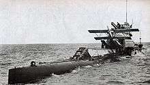 HMS M2 retrieving her seaplane
Location: in Lyme Bay
Maximum depth at the site is 30 m and minimum depth is 20m. Most dives will not exceed The keel is about 30 m below the surface at low tide, and the top of the conning tower is at about 20 m..
Topography: The wreck lies upright on the sea bed
Features: Wreck of a Royal Navy aircraft-carrying submarine
The wreck is designated as a "protected place" under the Protection of Military Remains Act 1986. - SS Maine is a wreck dive site in Devon
Location: about 10 miles off Dartmouth
Maximum depth at the site is 36 m.
Topography: The wreck is upright and on an even keel on a shingle bottom
Features: Wreck of a British cargo steamer torpedoed in World War I - Marguerite, (also known as also known locally as Benny's Wreck) is a wreck dive site in Dorset
Location: in Lyme Bay
Maximum depth at the site is 24 m and minimum depth is about 7.5 m off the sea bed (about 16 m).
Visibility is likely to be bad.
Topography: The wreck is now a twisted pile of metal lying on soft silt. Two boilers are visible, and the engine lies on its side. Most of the wreck is broken plate and frames standing up to a metre and a half off the bottom.
Ecology: lots of fish
Features: Wreck of a French cargo ship sunk in World War I
Hazards: Local boats regularly fish in the area, look out for net and line snags. - SS Mendi is a wreck dive site in off the Isle of Wight
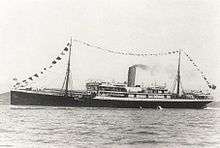 SS Mendi
Location: 11.3 nm from Saint Catherine's Light
Visibility is likely to be poor
Topography: The ship lies upright on the seabed, but has started to break up, exposing the boilers and engine. Parts of the bow and stern are quite well preserved but the hull is broken open in the middle.
Features: Wreck of a passenger ship - SS Mohegan is a wreck dive site in Cornwall
 SS Mohegan
Location: The Manacles, off the coast of the Lizard Peninsula
Access: boat dive
Features: Wreck of passenger steamship - RMS Moldavia is a wreck dive site in the English Channel
Location: off Beachy Head
Features: Wreck of a passenger steamer - HMS Montagu is a wreck dive site in Devon
_Heavy_Fittings_Removed_1906.jpg) HMS Montagu with many fittings removed during salvage attempts in the summer of 1906
HMS Montagu with many fittings removed during salvage attempts in the summer of 1906
Location: Lundy Island
Topography: all that remains is armor plate and a few unexploded 12-inch shells on the sea bed
Features: wreckage of a "Duncan" class pre-Dreadnaught battleship - RMS Mulheim is a wreck dive site in Cornwall
Location: Land's End
Features: Wreckage of large container ship. - MS Oslofjord is a wreck dive site
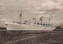 MS Oslofjord
Location:
Maximum depth at the site is 15 m.
Features: wreckage of a passenger liner - SS Persier is a wreck dive site
Location: - MS Piłsudski is a wreck dive site in Yorkshire
Location: off the River Humber - MV Pool Fisher is a wreck dive site in Isle of Wight
Location: off the Isle of Wight - HMS Port Napier is a wreck dive site in the Kyle of Loch Alsh
- Preussen is a wreck dive site
Location: Crab Bay - Radaas is a wreck dive site
Location: west of Portland Bill - Rondo is a wreck dive site in the Sound of Mull off the west coast of Scotland
- Rosehill is a wreck dive site
Location: in Whitsand Bay - Royal Adelaide is a wreck dive site
Location: at Chesil Beach - Royal Charter is a wreck dive site in Anglesey
Location: off the beach of Porth Alerth in Dulas Bay on the north-east coast of Anglesey - HMS Safari is a wreck dive site
- HMS Scylla is a wreck dive site in Cornwall
Location: off Whitsand Bay
scuttled - HMS Sidon is a wreck dive site
- SS Stanwood is a wreck dive site
- Stanegarth is a wreck dive site
Location: scuttled at Stoney Cove - SS Stella is a wreck dive site
Location: south of the Casquets, a group of rocks 13 km northwest of Alderney
SS Stella on Wikipedia - SS Thesis is a wreck dive site in Scotland
Location: in the Sound of Mull - Torrey Canyon is a wreck dive site in the western coast of Cornwall
- U-40 is a wreck dive site
- U-1195 is a wreck dive site
Location: to the south east of the Isle of Wight - SS Varvassi is a wreck dive site in Isle of Wight
Location: just off the Needles lighthouse - SS Walter L M Russ is a wreck dive site in the Bristol Channel
Location: at Grassholm
Inland dive sites
Quarries and lakes
Dive sites of the United Kingdom include a number of inland sites at disused quarries. These include:
- Dorothea quarry is a quarry dive site in Gwynedd, north Wales
Location: Nantlle Valley - Eccleston Quarry, (also known as Eccleston Delph and Eccy Delph) is a quarry dive site in Lancashire
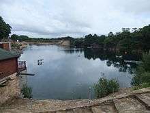 View along length of Eccleston quarry from the car park
Location: a mile south of Eccleston
Access: Shore dive. There are several entry and exit points including concrete slipways and sturdy steel deep water entry points with fin friendly steps. Most have railings with chain linkages.
Maximum depth at the site is slightly more than 20m.
Visibility is likely to be generally very poor
Topography: Flooded stone quarry, prepared for diving by removing garbage and sinking a number of items of interest for divers
Ecology: There are several kinds of fish, including Koi carp, roach, rudd, sturgeon and trout
Features: Items sunk to provide interest for divers include speedboats, a Jet Provost aircraft, armoured personnel carriers, a light tank, containers, a concrete tube, garden gnomes and a playground. There are also training platforms at various depths from 3m to 9m. These objects are marked by permanent buoys, and guidelines have been laid between the underwater feature to aid navigationin low visibility.
Hazards: No site specific hazards reported
Recommended equipment: No special equipment recommended
Special skills required: No special skills recommended, the site is used for entry level training.
Delph watersports centre, Parking, cafe, dive shop, changing facilities with hot showers, swimming pool, training room, equipment hire and 300 bar double filtered air filling station. - National Diving and Activity Centre is a quarry dive site in Gloucestershire, England, near to the border with Wales at Chepstow
Location: at Tidenham
Access: Shore dive. several entry points, including a ramp and pontoon jetty.
Maximum depth at the site is about 80 m maximum depth.
Topography: Large flooded limestone quarry
Features: There are several objects to entertain divers in depths ranging from 6 m to 76 m. These include motor vehicles, aircraft, platforms, large bore pipes, shotlines, decompression trapezes, an old diving bell, and garden gnomes.
Hazards: No site specific hazards reported
Recommended equipment: No special equipment recommended. Equipment should be appropriate to the dive plan.
Special skills required: No special skills recommended the site is used for diver training from entry level. Skills should be appropriate to the dive plan.
National Diving and Activity Centre, accommodation, parking, dive school, dive shop, equipment rental, air, nitrox and trimix fills, equipment rental, licenced cafe bar. - Slickstones Quarry is a quarry dive site in South Gloucestershire
Location: near the village of Cromhall
Access: Shore entry from old road at beach or pontoon jetty
Directions: 1.5 miles from J14 of the M5
Maximum depth at the site is 17 m.
Visibility is likely to be about 5 to 6m, but may be better in summer, and water temperature 4 to 12°C, varying seasonally
Topography: Flooded fossiliferous limestone quarry with slightly undulating rock bottom which slopes up to the former road entry
Ecology: Great Crested Newts
Features: Water features include two shipping containers for use as training platforms with the tops in approximately 7 and 10 metres of water, an aircraft cockpit, a racing catamaran powerboat, several cabin cruisers, a mine, a torpedo, two telephone boxes and the "buoyancy gym"
Hazards: No site specific hazards reported
Recommended equipment: No special equipment recommended.
Special skills required: No special skills recommended, the site is suitable for entry level training.
Cromhall diving centre, double filtered Air is available to 232 bar, continuous blend Nitrox, Trimix & 100% O2. Tea, coffee, and snacks at the Dive Centre - Stoney Cove is a quarry dive site in Leicestershire
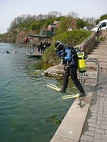 Diving at Stoney Cove
Location: between Stoney Stanton and Sapcote
Access: Shore dive
Maximum depth at the site is around 36 metres.
Topography: Large flooded granite quarry
Features: Several objects have been provided to entertain divers, including a Viscount aircraft cockpit, "Nautilus" submarine, archways beneath the pub, a Wessex helicopter, a bus, the "monster", the "galleon", a small aircraft wreck,, a deep hydrobox, submerged trees, a tower, a blow-off preventer, a 4-metre block house, a wooden boat, the wreck of the Stanegarth (the largest inland wreck in the UK) and an armoured personnel carrier.
Hazards: No site specific hazards reported
Recommended equipment: No special equipment recommended
Special skills required: No special skills recommended, the site is used for recreational and training dives.
Stoney cove dive centre, dive shop, gas filling station and scuba diving school. Nemo's pub and a function room for private events. - Wast Water, (also known as Wastwater) is a lake dive site
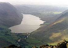 Wast Water seen from the summit of Great Gable, 4.5 km to the NE.
Location: in Wasdale valley in the western part of the Lake District National Park
Maximum depth at the site is 79 metres (258 feet).
Visibility is likely to be quite clear at the bottom, but there's nothing much to see.
Topography: The lake is approximately 4.6 kilometres long and 600 metres wide and is the deepest lake in England. It is a glacially 'over-deepened' valley. The surface of the lake is about 60 m above sea level, while its bottom is over 15 m below sea level.
Features: A "gnome garden" complete with picket fence was placed in the lake at 48 m as a point of interest for divers to explore. It was removed from the bottom of Wastwater by police divers after three divers died in the late 1990s, but it is rumoured that the garden has been replaced at a depth greater than 50 m, which is the limit beyond which the police are not allowed to dive
Hazards: No site specific hazards reported
Recommended equipment: equipment appropriate to the dive plan.
Special skills required: skills appropriate to the planned depth of dive and equipment to be used.
Owned by the National Trust.
Cave diving sites
Respect
Several of the wreck diving sites are archaeological sites or war graves.
Get help
Emergency services
- . Police.
- . Ambulance service
- . Sea rescue
- . Recompression chamber
- . DAN hotline
Get service
The UK has an extensive range of service organisations for recreational and technical diving, and is one of the world centres for commercial diving.
Learn
Recreational and technical diving schools can be found in many centres, and the British Sub-Aqua Club (BSAC) trains members at many of their branches
Buy
The full range of diving equipment can be found at UK retail outlets, and a significant number of diving equipment manufacturers are based in the country.
Rent
Do
Cave diving and wreck diving
Fix
Service details
Get around
Stay safe
UK diving conditions require a relatively high level of competence and fitness compared to the tropical scuba destinations.