Diving in South Africa/HMS Birkenhead wreck
The dive site HMS Birkenhead or just The Birkenhead is an offshore historical wreck on the rocky reef at Birkenhead Rock to the south west of Danger Point, near Gansbaai in the Western Cape province of South Africa.
Understand


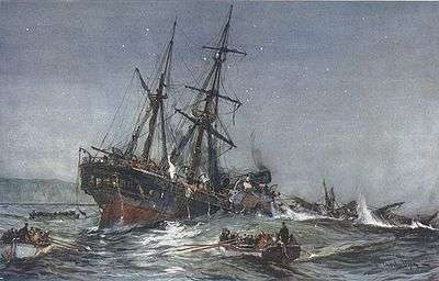
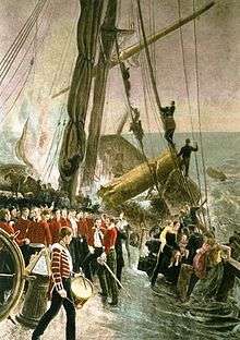
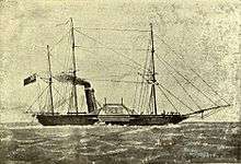
This is an important historical wreck for both engineering and cultural reasons. The vessel was one of the earliest iron steamships, one of the last paddle steamers of the Royal Navy, and the epic story of the wreck is a significant item of British and South African history and folklore. The wreck of the Birkenhead is famed for the story of the soldiers who stood by while the women and children were loaded into the few boats that were seaworthy. There are various tales of heroism and stupidity, and a large number of apocryphal anecdotes about shark attacks and bodies being eaten by huge red steenbras. The engines are still in fairly intact condition, and differ considerably from later triple expansion steam engines which were more or less standardised in general layout for a long time.
Position
- S34°38.654' E019°17.155' (boiler)
- S34°38.660' E019°17.146' (starboard paddle hub)
- S34°38.657' E019°17.163' (port paddle hub)
- S34°38.674' E019°17.148’ (engine)
This site is in a Marine Protected Area (2004) and a closed area. A special permit is required.
Name
The name "HMS Birkenhead" is the name of the ship wrecked on 26 February 1852 at this site.
| Designed displacement | 1918 | tons | |
| Loaded displacement | 2000 | tons | |
| Length | 64 | .0 | m |
| Beam | 11 | .4 | m |
| Draught | 4 | .8 | m |
| Rig | Built as a brig, later rerigged as a barquentine | ||
| Masts | 3 | ||
| Crew | 125 | ||
| Date of launch | 30 | December 1845 | |
| Construction | Iron | ||
| Ship class | Designed as a Frigate, but served as a troopship | ||
| Propulsion | Sail, plus 2 x Forrester & Co side lever steam engines driving 6m paddle wheels | ||
| Speed | 10 | kt as troopship | |
| Armament | 2 | 96-pounder pivot guns | |
| 4 | 68-pounder broadside guns | ||
| Builder | John Laird shipyard, Birkenhead |
Depth
Maximum depth is about 28m, and the adjacent reef slopes gradually up to the blinder, which is shallow enough for the ship to have hit it. Average depth on the wreckage is likely to be about 26m, and the highest part of the wreckage, on top of the engines, is at about 24m.
Visibility
Visibility will vary, but may exceed 15m on a good day. Visibility at depth may differ considerably from nearer the surface, but you will not know until you dive. Lighting will also vary, and will be better on a sunny day, though the amount of light that penetrates to the bottom is very much dependent on the surface visibility, and depth of the thermocline. The sand bottom reflects light, so those parts of the wreck near the sand may be better illuminated that parts on the darker reef areas.
Topography
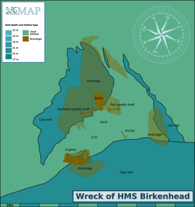
The large sandstone reef to the south east of the wreckage with a pinnacle at the blinder known as Birkenhead Rock slopes down to about 27m at the edge of the sand, which runs roughly east-west magnetic. The slope of this reef is quite steep to the east, but flattens out a bit where the engines of the wreck lie stacked at the edge of the sand.
The bottom is fairly flat to the north of this reef, and is sandy patches and low rock reef with scattered wreckage. To the north the reef starts flat but gets a bit more profile further north, but never more than about a metre. To the west the reef is low and sandy, with odd chunks of wreckage as the highest points. Reef to the east is scattered boulders with sand between.
The ship ran aground while travelling roughly south-east, and the wreckage is aligned more or less north west to south east, with the stern to the north west.
Much of the wreckage is on or around a patch of white sand, and is concentrated in two main areas:
- The engines are lying on their sides at the edge of the high reef to the south, with the tops facing north, and one engine lying fairly flat on the bottom with some components under the sand. The other engine is partly on top of the first, with the large cylinder propped on top of the first engine at the east side, furthest from the equivalent cylinder of the first engine. At first glance the engines appear to have only one cylinder, at the extreme end, but on closer inspection there appears to be a smaller cylinder in line and closer to the output end. These appear to have been double expansion side lever type engines, similar in principle to the beam engines which were popular at that time for stationary work, but how the second cylinder is linked in is unclear (some similar engines have an air pump cylinder). The engines appear to be based on substantial foundations, and are held together by an open structure of pillars and beams, with assorted diagonal bracing. Most of this is well covered by invertebrate growth and is not easy to identify. However, there appears to be a long beam (the side lever) on the lower side of the engines, roughly parallel to the base structure, which may be the side lever which transfers piston movement to the paddle wheel drive shaft. To the south of the engines, slightly up the reef, is a large section of flat structure, which comprises closely spaced parallel frames, almost like a grating, but only in one direction. There are also some odd bits of machinery and piping on the reef.
- The paddle wheels and shafts are clustered several metres to the north of the engines in much the same alignment as when on the ship, with a boiler between them. Each paddle wheel had its own shaft and engine, and they could be rotated at different speeds, which could be used to maneuver the vessel. The paddle hubs are three parallel discs near the outboard end of the shafts, connected to each other by bars, and having a few short stumps of the paddle spokes remaining. At the inboard end of each shaft there is a large disc, which may have carried an eccentric stub shaft to act as the connection to the connecting rod. The port paddle shaft has what may be the remains of a shaft bearing close against the inboard disc.
- The boiler is on top of a large mound of wreckage which includes what might be a spare low pressure piston, as it is a large flat iron disc about 150mm thick with a deep square groove round the edge which could be for a ring, and a hole in the centre which could be for a piston rod. Just north of this piston there is a structure with a lot of parallel pipes and three rounded edged castings in a neat row which could be firebox openings.
There are also other groups of parallel large diameter tubes to the west of this boiler which could be fireboxes from another boiler, and assorted bits of hull structure around this area, but most is not easily identifiable.
- An iron anchor lies in the sand to the east of the engines, near the reef edge, One fluke is buried and the other sticks almost straight up, with the shank on the sand. No stock is visible.
Geology: Ordovician sandstones of the Peninsula formation.
Conditions
More information is needed on what weather conditions are best for diving this site.
Good conditions have been experienced in December and April, but then again on other occasions in the same months, conditions have been bad.
The site is exposed to wind and swells from south west through to south east, so should be dived when the forecast is for low swell and light winds, as the boat trip will be uncomfortable in a chop.
The site is reasonably protected from northerly winds, but they may produce an unpleasant chop. It is not clear which season is more likely to have good conditions.
Water temperature may range from about 17°C at the surface to 12°C at the bottom, with a strong thermocline.
Get in
This is a boat dive, as it is about 1.5km from the nearest shore. The usual access is from Gansbaai harbour at S34°35.041'S E019°20.807'E', where there is a good commercial slipway available to the public.
The alternative launch site at Kleinbaai at S34°36.951' E019°21.348'E on the other side of the Danger Point peninsula is slightly closer, but a less protected slipway.
The site is about 10.5km from Gansbaai harbour, or 8.5km from Kleinbaai slipway.
Parking at the harbour slipway is adequate, and reasonably close to the water. Boats would normally be loaded in the parking area before launching, and unloaded at the same place. The parking area at Kleinbaai is more basic, and has a dirt surface, which can be muddy if it rains, but it is also close to the slipway, and boats are also usually loaded and unloaded in the parking area. The Kleinbaai slipway is also used by the cage-diving boats which take tourists to Dyer Island to see Great White sharks.
See
Marine life
Marine life in this area includes lots of sponges, colonial ascidians and small sea fans, and there are large numbers of noble corals on the reefs nearby.
Much of the wreck is quite heavily overgrown with benthic invertebrates, but some areas are fairly clean, largely where crustose coralline algae have taken hold, or in a few cases where the wreckage is a copper based alloy. The benthos includes a variety of sponges, mostly fairly small, some small gorgonians, the occasional noble corsl, assorted bryozoans, hydroids, nudibranchs and anemones.
There are large numbers of West coast rock lobster sheltering in the wreckage, and quite a lot of fish. As usual, Hottentot seabream are everywhere, but there are also fair numbers of Red stumpnose, Redfingers, and possibly barred fingerfin. Also seen were Pyjama shark, Janbruin, Roman and Spotted gully shark.
Bryde's whales, jumping Bronze whalers, and gannets may be seen from the boat if you are lucky.
Great white sharks have not been seen recently, but are known to frequent the general area.
Features
Scattered wreckage of a historical wreck of great cultural significance. The wreckage includes remains of the paddle wheels, boiler and engine, which is a very early model and quite interesting in design. There are also a few anchors, cannon and similar generic type artifacts.
Photography
The site is fairly deep, and lighting is likely to be poor. The wreckage is generally fairly large items, which require a wide angle lens to fit them in the picture without losing too much detail, and powerful external strobes are recommended. Natural light photos may be acceptable if the visibility is good and the lighting better than usual, but it is likely that not much detail will be picked up. Macro photography will produce adequate results on small subjects, but these are not why you dive this site. You dive here to see the wreck, so try to get some photos of it. You may be lucky.
Video will produce best results with a wide angle lens, and preferably powerful lights.
Suggested Routes
The wreck site is fairly small, and it is possible to see all the major features on a single dive. The recommended places for dropping the shot are near to the engines, at the edge of the high reef, which is relatively easy to confirm with an echo sounder, and as near as possible to the boiler, which is central and therefore makes it likely that a bit of error will not make you miss the whole site, The route description is based on a shotline position near the engines.
- Descend to the shot, and see if you can spot the engines, or failing that, the high reef to the south. If neither of these can be seen, look around for other wreckage.
- If you land on the sand, head south to the high reef, and if you land on reef shallower than 25m, head north until you get to the sand. When at the border between reef and sand, check for wreckage again. If you see the anchor or large boulders you are likely to the east of the engins, so swim west along the edge of the sand. If the bottom is flat and sandy or just sand north of the reef you are more likely to the west of the engines, so swim east along the reef edge.
- Once at the engines, spend a bit of time looking at them as you may never see this type of engine again. There are two, One lies on its side on the sand with the other lying on its side partly supported by the bottom one. The big cylinders are the low pressure cyinders, and the beam across the top transfers the force and movement of the piston to rods at the sides which move the beams, which are parallel to the base of the engine, and pivoted on a bearing about half way along the base. The far end of the beam was connected to a connecting rod which drove the propeller shaft. This style of engine structure is similar to the original stationary beam engines, but with beams at the bottoms of the sides instead of a single beam on top. There is a second cylinder, which is smaller, next to the big cylinder. This was a high pressure cylinder, and the steam would go through this first, then the low pressure cylinder.
- When you have looked at the engines, swim magnetic morth from the east end of the engines. This will take you across the sand to the paddle shafts. The paddle shafts had the paddle wheels at the outboard ends, and the hubs are still easily recognisable as triple discs near the ends of the shafts. The inboard end of each shaft would be driven by the connecting rod from an engine and there would have been a couple of large bearings supporting the shafts.
- The other shaft is in line with the first one you found, in the direction of the big solid disc at the shaft end furthest from the paddle hub.
- Half way between the shafts you can see the spare piston, and just north of that, the boiler. The fireboxes are on the north side.
- There is an assortment of unidentified wreckage around the boiler, extending about 10m or more in an arc to the north.
- The last item on the tour is the anchor, which is south of the eastern paddle hub, on the sand almost back at the high reef, and to the east of the engines.
Stay safe
Hazards
If a large swell is running, there will be a break at the rock. This could be dangerous to the boat, and it should stay clear, however in those conditions there may also be strong surge on the wreck and poor visibility. Even on a flat day at low tide the pinnacle will break, and on days when there are south-west and south-east components to the swell, both may break at the same time. This may happen sporadically and without warning, so be careful.
The site is near to one of the world hotspots for the Great White shark, the seal colony at Dyer Island. This may be considered a hazard, and the reports of survivors from the wreck indicated that many of the shipwrecked crew and passengers were taken by sharks. Most scuba divers report that they have seen no sharks during the dive, nevertheless this may not be the best place to dive in low visibility. It is also recommended not to spend a long time at the surface, or to plan to do long decompression stops, as the visibility is often worst near the surface.
There may be slight currents, and the biggest hazard from this is not finding the wreck. These may change over a short period, and can be strong enough to require mild effort to remain in place near the bottom. Currents of this strength may be associated with incoming tide and deteriorating visibility, and are known to set east on some occasions.
Skills
Certification appropriate to the depth will be required by most charter boats. The ability to navigate by compass and to deploy a DSMB will be very useful. Wreck diver training is not needed, as the wreckage is very open and there are no penetrations possible.
Equipment
This is a wreck that is not easy to get to, so it is desirable to maximise your dive time by using Nitrox. It is also recommended to carry a compass, and a DSMB to alert the boat that you are surfacing, so it can pick you up without a long delay on the surface.
Back to Diving in South Africa#Gansbaai