County Armagh
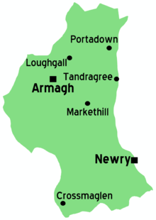
County Armagh is a county in Northern Ireland.
Cities, towns and villages

Cities
- 🌍 Armagh - Historic city with two cathedrals one dating back to 13th century and the oldest library in Northern Ireland.
- 🌍 Newry - split with County Down in south-eastern of Northern Island between the Mourne Mountains and the Ring of Gullion
Towns
Understand
County Armagh's reputation traditionally hinges on its role as the ecclesiastical centre of Ireland since 432 CE (the Primates of All Ireland in both the Church of Ireland and the Catholic Church have their seats in the city of Armagh) and an area marred by conflict during the Troubles, with names like Portadown or Crossmaglen seared into collective memories of that period. County Armagh is nicknamed the Orchard County for its tradition of apple cultivation – and cider making.
Geographically, the northern and central parts of County Armagh are dominated by comparatively flat, pleasant, rolling countryside. In the far north, the county extends to the shore of Lough Neagh. South of the city of Armagh, the land begins to become hillier until, as one approaches the Mourne and Cooley Mountains, the Ring of Gullion Area of Outstanding Natural Beauty rises to the dignity of mountains notably at Slieve Gullion (the highest point in the county).
County Armagh is separated from County Tyrone by the River Blackwater and from County Down by the Newry River, which is partly canalized. Like other counties in Northern Ireland, Armagh is not an administrative unit but rather a widely recognized geographical area. Since the 2015 reorganization of local districts in Northern Ireland, County Armagh has been administratively divided between the districts of Armagh, Banbridge, and Craigavon and of Newry, Mourne, and Down.
Get in
Car is the usual means of travel over medium to long distances. The M1 crosses the northern part of the county, serving communities in the area of Lurgan and Craigavon. A number of primary routes converge at Armagh; these include the A3, A28, and A29. These are relatively good-quality A roads, but not dual carriageway. Newry is a key transportation junction for South Armagh and also the gateway to the Mourne Mountains, Dundalk, and Cooley Peninsula, located on the A1 which (as the M1 and N1) connects Belfast and Dublin.
Get around
Newry's major roads (such as the A1 and A2) are largely inadequate to the volume of traffic passing in, out, and through, so the traveller should be prepared for stoppages at many times of day. Otherwise, the usual caveats about travel in Northern Ireland apply: traffic drives on the left, distances are marked in miles (and speeds in miles per hour), cars entering roundabouts need to yield to vehicles already in the roundabout (and sometimes have a traffic light before entering the roundabout), etc.
See
- Armagh with its Catholic and Anglican cathedrals, Bishop's Palace, county museum, and other points of interest
- Navan Fort just outside Armagh: this is a former royal site, complex of earthworks, and nature centre with a very impressive visitor centre
Do
Slieve Gullion, 89 Drumintee Rd, Meigh, Newry BT35 8SW (Follow the signs for Slieve Gullion Forest Park; you can drive most of the way up the mountain on a zigzagging one-way road till you reach a parking lot near a scenic overlook from where much of South Armagh is visible. The path to the summit is a bit hard to spot, but it begins perhaps 30 m past the parking lot on the right of the one-way road. The ascent would be difficult for a casual stroll, but child's play for a serious mountaineer. A rather steep initial climb leads you to a turnstile, after which the path zigzags on an easy gradient for some distance until you reach a steeper, rockier stretch that is equivalent to roughly 200 steps of a staircase. This leads to a rock shelter with an information panel about the mountain's archaeology and mythology. The path curves at a relatively easy gradient again until you reach the final ascent to the summit, which is steeper, equivalent to roughly 100 stairs). Once at the summit, you will first come to the cairn (set up over a passage tomb) at the southern, highest end of the mountain. From here you can pick up a path that meanders northwards on the crest of the mountain, where the ground in many places is surprisingly marshy, until you reach the beautiful (and by reputation enchanted) little lake at the northern end of the mountain. Just beyond the lake is the other cairn, likewise set over a passage tomb. Views from here include the Mourne Mountains, the Cooley Peninsula, and Carlingford Lough. Free.
Stay safe
Although Northern Ireland is at peace today, Co. Armagh is still one of the more politically and sectarian divided regions of the province. It has seen many terrorist attacks.
Go next
- East to County Down
- North west to County Tyrone
- South west to County Monaghan, Republic of Ireland
- South east to County Louth, Republic of Ireland