Biharinath
Biharinath is in the Rarh region of West Bengal, in India.

Understand
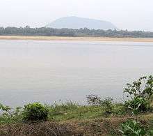
Biharinath is the second highest hill in sub-Himalayan West Bengal. It is 451 m (1,480 ft) high.
It is a place where one can take a break from drudgery and daily monotonous job and simply rejuvenate one's mind and soul. It is part of the wonderful Rarh countryside.
The tourist spot is located at the foot of the hill, near Biharinath temple. There are small villages in the area. Saltora and Tiluri are comparatively more populous places.
Get in
Biharinath is 16km from Madhukunda, a railway station on the Asansol-Adra track and off the Saltora-Madhukunda road.
One can travel by road from Raniganj via Saltora or across the Damodar River over the bridge near Dishergarh/ Sanctoria, travel a little towards Raghunathpur and turn left for the road to Madhukunda and then on to Biharinath.
There is only one bus from Raniganj station that goes directly to Biharinath, but from Bankura there are more direct buses to Biharinath. From Madhukonda Rail Station there are shuttle services for Biharinath. One can also come from Burnpur/Asansol by two wheeler, crossing the temporary bridge over the river Damodar.
One can also drive down from Kolkata to Biharinath. It will take approximately 5-6 hours. The route (around 230 km) is Kolkata > Dankuni > Bardhaman (NH 2 bypasses the town area) > Durgapur > Raniganj (till here NH2) > Saltora> Biharinath. The drive down NH2 is a pleasure, but after that you are on a rural track, though that drive has its own charm.
Get around
Walk or have your own transport. Alternatively, a hotel can make arrangements for you to use a bullock cart to move around Biharinath.
See
- 🌍 Biharinath Parbat. You can climb, take along a local guide (tip him) in order that you are not lost
- 🌍 Biharinath Temple. This is most famous Shiva temple in the western part of Bengal and for some ways beyond the state. Millions of pilgrims throng there throughout the year.
- Hills and forests all around.
- Temple of Lord Shiva.
Do
Buy
Raniganj and Asansol are the nearest urban shopping centres. Asansol is 16 km by train from Madhukunda railway station and Burnpur and Asansol are just 4-6 km from Biharinath via the newly-opened (2015) bridge.
Eat
Eat at your place of stay. Biharinath Tourist Point is the only place where a full functioning restaurant exists at Biharinath.
Drink
Biharinath Tourist Point also sells packaged water, soft drinks and ice cream.
Sleep
- 🌍 Atithisala, ☎ +91 9635368647. Run by Saltora Block. Car pick up from Raniganj can be arranged. There is hardly any attached toilet room or restaurant. There is no generator or boundary wall. Rooms and toilets are not clean, no standard furniture or television in the room. ₹500 per room, ₹1000per bed in 8-bed dormitory.
- 🌍 Biharinath Tourist Point, ☎ +91 8017745849, +91 8017202499, +91 9732861020. Basic urban-style amenities and eatery with varied menu. Accommodations range from dormitory to A.C. "super deluxe" room. Can also arrange bull cart transport and boating on the Damodar River. ₹800-1600.
Connect
Go next
- Baranti
- Garh Panchakot, historical ruins with a grand view of Panchet Lake
- Joychandi Pahar, popular for picnics and rock-climbing
- Maithon Dam
- Panchet Dam
- Susunia Hill
Those who have their own transport can easily make it to these places.