Zumalai
Zumalai is a city[1] and subdistrict (former Mape-Zumalai) in East Timor. The subdistrict has been part of Cova Lima District since 2003. Before that, it was part of Ainaro District. The Zumalai subdistrict has six main villages: Fatuleto, Raimea, Zulo, Mape, Lour, and Taisilin.[2]
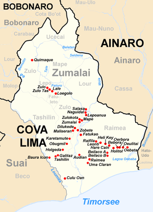
Subdistrict of Zumalai
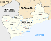
Location of Zumalai city in the east of Cova-Lima district.
Language
There are three main local languages in Zumalai subdistrict, Bunak, Kemak, and Tetun-Terik.
Notes
- Zumalai (Approved) at GEOnet Names Server, United States National Geospatial-Intelligence Agency
- Atambua, Indonesia, Sheet SC 51-08 (topographic map, scale 1:250,000), Series U-502, United States Army Map Service, 1963
gollark: Yet again, SQLite has surprised me with a useful feature nobody seems to know about, `spellfix1`.
gollark: https://www.wikihow.com/Enrich-Uranium
gollark: I sort of vaguely assumed you were German. Because of your mildly German-sounding name.
gollark: Fascinating.
gollark: Hmm, are you in the ÜS?
This article is issued from Wikipedia. The text is licensed under Creative Commons - Attribution - Sharealike. Additional terms may apply for the media files.