Zörnigall
Zörnigall is a village and a former municipality in Wittenberg district in Saxony-Anhalt, Germany. Since 1 January 2011, it is part of the town Zahna-Elster. It belonged to the administrative municipality (Verwaltungsgemeinschaft) of Elbaue-Fläming.
Zörnigall | |
|---|---|
Ortsteil of Zahna-Elster | |
Location of Zörnigall 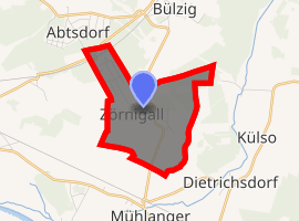
| |
 Zörnigall 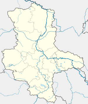 Zörnigall | |
| Coordinates: 51°52′17″N 12°45′23″E | |
| Country | Germany |
| State | Saxony-Anhalt |
| District | Wittenberg |
| Town | Zahna-Elster |
| Area | |
| • Total | 3.57 km2 (1.38 sq mi) |
| Elevation | 76 m (249 ft) |
| Population (2009-12-31) | |
| • Total | 901 |
| • Density | 250/km2 (650/sq mi) |
| Time zone | CET/CEST (UTC+1/+2) |
| Postal codes | 06888 |
| Dialling codes | 034922 |
| Vehicle registration | WB |
Geography
Zörnigall lies about 8 km southeast of Lutherstadt Wittenberg.
Economy and transportation
Federal Highway (Bundesstraße) B 187 between Wittenberg and Jessen is about 1 km to the south.
gollark: Just use the C preprocessor.
gollark: (more easily than the weird regex notation of recursive capture groups)
gollark: I'm sure it lets you define functions.
gollark: As planned.
gollark: Although I actually wrote the regex as```pythonWHITESPACE = r"[\t\n ]*"NUMBER = r"\-?(?:0|[1-9][0-9]*)(?:\.[0-9]+)?(?:[eE][+-]?[0-9]+)?"ARRAY = f"(?:\[{WHITESPACE}(?:|(?R)|(?R)(?:,{WHITESPACE}(?R){WHITESPACE})*){WHITESPACE}])"STRING = r'"(?:[^"\\\n]|\\["\\/bfnrt]|\\u[0-9a-fA-F]{4})*"'TERMINAL = f"(?:true|false|null|{NUMBER}|{STRING})"PAIR = f"(?:{WHITESPACE}{STRING}{WHITESPACE}:{WHITESPACE}(?R){WHITESPACE})"OBJECT = f"(?:{{(?:{WHITESPACE}|{PAIR}|(?:{PAIR}(?:,{PAIR})*))}})"VALUE = f"{WHITESPACE}(?:{ARRAY}|{OBJECT}|{TERMINAL}){WHITESPACE}"```which is much easier.
This article is issued from Wikipedia. The text is licensed under Creative Commons - Attribution - Sharealike. Additional terms may apply for the media files.