Yeongwol County
Yeongwol County (Yeongwol-gun) is a county in Gangwon Province, South Korea.
Yeongwol 영월 | |
|---|---|
County | |
| Korean transcription(s) | |
| • Hangul | 영월군 |
| • Hanja | 寧越郡 |
| • Revised Romanization | Yeongwol-gun |
| • McCune-Reischauer | Yŏngwŏl-gun |
 Emblem of Yeongwol | |
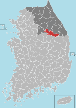
 Location in South Korea | |
| Country | |
| Region | Gwandong |
| Administrative divisions | 2 eup, 7 myeon |
| Area | |
| • Total | 1,127.36 km2 (435.28 sq mi) |
| Population (2014.5) | |
| • Total | 40,178 |
| • Density | 44.6/km2 (116/sq mi) |
| • Dialect | Gangwon |
Well known as the place where King Danjong, the sixth king of Joseon Dynasty, was exiled when he was forced to abdicate by his uncle, who became Sejo of Joseon. It is also where Danjong was buried after he was murdered in 1457, following the attempts by six martyred ministers to restore him to power, after he was perceived to be a continuing threat to the rule of his uncle. It is also where the Joseon Dynasty poet Kim Sat-gat is buried.[1]
Cities
- Gonggiri
Climate
| Climate data for Yeongwol, Yeongwol County (1981–2010, extremes 1995–present) | |||||||||||||
|---|---|---|---|---|---|---|---|---|---|---|---|---|---|
| Month | Jan | Feb | Mar | Apr | May | Jun | Jul | Aug | Sep | Oct | Nov | Dec | Year |
| Record high °C (°F) | 12.3 (54.1) |
20.6 (69.1) |
25.1 (77.2) |
33.3 (91.9) |
35.3 (95.5) |
35.6 (96.1) |
37.2 (99.0) |
38.7 (101.7) |
33.6 (92.5) |
28.4 (83.1) |
25.1 (77.2) |
15.5 (59.9) |
38.7 (101.7) |
| Average high °C (°F) | 2.2 (36.0) |
5.5 (41.9) |
11.1 (52.0) |
18.7 (65.7) |
23.9 (75.0) |
27.5 (81.5) |
28.9 (84.0) |
29.5 (85.1) |
25.5 (77.9) |
20.0 (68.0) |
11.6 (52.9) |
4.4 (39.9) |
17.4 (63.3) |
| Daily mean °C (°F) | −4.0 (24.8) |
−1.2 (29.8) |
4.4 (39.9) |
11.3 (52.3) |
16.6 (61.9) |
20.8 (69.4) |
23.6 (74.5) |
24.0 (75.2) |
19.1 (66.4) |
12.4 (54.3) |
4.7 (40.5) |
−1.9 (28.6) |
10.8 (51.4) |
| Average low °C (°F) | −9.6 (14.7) |
−7.4 (18.7) |
−1.9 (28.6) |
4.0 (39.2) |
9.7 (49.5) |
15.2 (59.4) |
19.8 (67.6) |
20.2 (68.4) |
14.5 (58.1) |
6.8 (44.2) |
−0.9 (30.4) |
−7.2 (19.0) |
5.3 (41.5) |
| Record low °C (°F) | −23.5 (−10.3) |
−23.1 (−9.6) |
−15.5 (4.1) |
−6.9 (19.6) |
1.7 (35.1) |
4.1 (39.4) |
10.8 (51.4) |
11.5 (52.7) |
3.7 (38.7) |
−5.6 (21.9) |
−11.7 (10.9) |
−19.5 (−3.1) |
−23.5 (−10.3) |
| Average precipitation mm (inches) | 21.3 (0.84) |
25.3 (1.00) |
50.0 (1.97) |
70.5 (2.78) |
87.4 (3.44) |
143.9 (5.67) |
292.3 (11.51) |
291.7 (11.48) |
150.3 (5.92) |
40.1 (1.58) |
32.2 (1.27) |
19.3 (0.76) |
1,224.1 (48.19) |
| Average precipitation days (≥ 0.1 mm) | 6.9 | 6.7 | 9.0 | 8.9 | 9.2 | 10.0 | 16.6 | 15.5 | 10.3 | 6.5 | 7.4 | 6.4 | 113.4 |
| Average snowy days | 9.2 | 7.1 | 5.3 | 0.2 | 0.0 | 0.0 | 0.0 | 0.0 | 0.0 | 0.1 | 2.3 | 6.1 | 30.3 |
| Average relative humidity (%) | 63.9 | 60.6 | 58.7 | 55.0 | 63.8 | 70.5 | 79.9 | 79.3 | 76.9 | 73.1 | 68.4 | 66.8 | 68.1 |
| Mean monthly sunshine hours | 178.6 | 173.0 | 192.7 | 207.3 | 213.6 | 187.3 | 133.1 | 149.1 | 154.4 | 175.6 | 153.3 | 172.8 | 2,090.9 |
| Percent possible sunshine | 58.0 | 56.6 | 52.0 | 52.6 | 48.7 | 42.6 | 29.7 | 35.5 | 41.4 | 50.3 | 50.0 | 57.7 | 46.9 |
| Source: Korea Meteorological Administration[2][3][4] (percent sunshine and snowy days)[5] | |||||||||||||
Culture and tourism
- Jangreung [장릉] (Youngwoleup)
- Eorayeon [어라연] (Youngwoleup)
- Gossigul [고씨굴] (Kimsatgat myeon)
- Kimsatgat myeon sites [김삿갓유적지] ( Kimsatgat myeon)
- Cheongryeongpo [청령포] (Youngwoleup)
- Youngwol dahanu Village [다한우마을] (Jucheonmyeon)
- Byeolmaro Observatory [별마로 천문대] (Youngwoleup)
- Donggang Photo Museum [동강사진박물관] (Youngwoleup)
- Bongraesan [봉래산] (Youngwoleup)
- Hanbando terrain (Hanbando myeon)
Festival
DongGang International Photo Festival - This festival is held in Yeongwol every year. It features events such as the DongGang Photography Award Exhibition, International Open Call, Photojournalists Exhibition and Gangwon Province Photographers Exhibition.[6] Although it is held at the Dong River Photo Museum, visitors can find the works throughout Yeongwol County during the photo festival.
Gallery
References
- Lee, Jeong-bong (1 June 2011). "A hamlet rich in history and art". Joongang Daily. Archived from the original on 16 February 2013. Retrieved 27 January 2013.
- "평년값자료(1981–2010), 영월(121)" (in Korean). Korea Meteorological Administration. Retrieved 9 December 2016.
- "기후자료 극값(최대값) 전체년도 일최고기온 (℃) 최고순위, 영월(121)" (in Korean). Korea Meteorological Administration. Retrieved 9 December 2016.
- "기후자료 극값(최대값) 전체년도 일최저기온 (℃) 최고순위, 영월(121)" (in Korean). Korea Meteorological Administration. Retrieved 9 December 2016.
- "Climatological Normals of Korea" (PDF). Korea Meteorological Administration. 2011. p. 499 and 649. Archived from the original (PDF) on 7 December 2016. Retrieved 9 December 2016.
- Herald, The Korea (22 June 2018). "[Travel Bits] Festivals, sights around Korea". Retrieved 23 June 2018.
External links
| Wikimedia Commons has media related to Yeongwol. |

- Yeongwol County tourism office home page
.jpg)
