Wyoming Highway 487
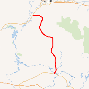
Wyoming Highway 487 (WYO 487) is a 71.56-mile-long (115.16 km) state highway in northeastern Carbon County, Wyoming and southeastern Natrona County, Wyoming that runs from its south end at US 30/US 287 to a north end at WYO 220.
| |||||||
|---|---|---|---|---|---|---|---|
| Shirley Basin Road | |||||||

WYO 487 highlighted in red | |||||||
| Route information | |||||||
| Maintained by WYDOT | |||||||
| Length | 71.56 mi[1] (115.16 km) | ||||||
| Existed | Mid 1970s[1]–present | ||||||
| Major junctions | |||||||
| South end | |||||||
| North end | |||||||
| Location | |||||||
| Counties | Carbon, Natrona | ||||||
| Highway system | |||||||
State highways in Wyoming
| |||||||
Route description
Wyoming Highway 487 begins its south end at US 30/US 287 (Old Lincoln Hwy.) in Medicine Bow. WYO 487 travels north towards Shirley Basin and intersects WYO 77 at 22.1 miles (35.6 km), that route's southern terminus. Again WYO 487 intersects WYO 77 at its north end, but at 45 miles (72 km). WYO 487 travels another 27 miles (43 km) to its north end at Wyoming Highway 220 which is located 11 miles (18 km) NE of Alcova and 19 miles (31 km) SE of Evansville.
History

Wyoming Highway 75 was created during the early 1970s with the inception of the Wyoming secondary state route system. Highway 75 was routed along the path of present day Wyoming Highway 487 between the two junctions of current Wyoming Highway 77 in Shirley Basin. When Wyoming 487 was rerouted over Highway 75, old WYO 487 was recommissioned as WYO 77, and WYO 75 was decommissioned. The renumbering occurred in the mid-1970s.[2]
Major intersections
| County | Location | mi | km | Destinations | Notes |
|---|---|---|---|---|---|
| Carbon | Medicine Bow | 0.00 | 0.00 | Southern Terminus of WYO 487 | |
| | 22.1 | 35.6 | Southern Terminus of WYO 77 | ||
| | 45.0 | 72.4 | Northern Terminus of WYO 77 | ||
| Natrona | | 71.56 | 115.16 | NorthernTerminus of WYO 487 | |
| 1.000 mi = 1.609 km; 1.000 km = 0.621 mi | |||||
References
- Official 2003 State Highway Map of Wyoming
- GoogleMaps
