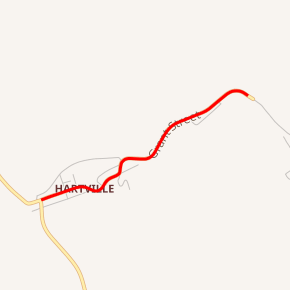
Wyoming Highway 318
Wyoming Highway 318 (WYO 318) is a short east-west 1.09-mile-long (1.75 km) spur route off Wyoming Highway 270 in northeastern Platte County.
| ||||
|---|---|---|---|---|

WYO 318 highlighted in red | ||||
| Route information | ||||
| Maintained by WYDOT | ||||
| Length | 1.09 mi[1] (1.75 km) | |||
| Major junctions | ||||
| West end | ||||
| East end | Dead End in Sunrise | |||
| Location | ||||
| Counties | Platte | |||
| Highway system | ||||
State highways in Wyoming
| ||||
Route description
Wyoming Highway 318 begins at Wyoming Highway 270 in the small Town of Hartville. WYO 318 travels east as Hartville's Main Street for a mile till it reaches the old mining town of Sunrise at 1.09 miles.[2][3] Upon reaching the former town, WYO 318 ends at a road closed sign as the mine property is gated. The Sunrise Mine operated until 1980 and produced 42,457,187 tons of iron ore[4][5]
History
The section of present-day Wyoming Highway 270 from US 26 at Guernsey north to Hartville at present-day Wyoming Highway 318 was formerly designated as Wyoming Highway 318 prior to the 1970s. Highway 318 used to begin as US 26 at Guernsey and end at Sunrise with a 90 degree turn at Hartville. The stretch between Guernsey and Hartville was recommissioned as Wyoming Highway 270 when that road was completed between Manville and Hartville to maintain continuity.[6]
Major intersections
The entire route is in Platte County.
| Location | mi | km | Destinations | Notes | |
|---|---|---|---|---|---|
| Hartville | 0.00 | 0.00 | Western terminus of WYO 318 | ||
| Sunrise | 1.09 | 1.75 | Dead End | Eastern terminus of WYO 318 | |
| 1.000 mi = 1.609 km; 1.000 km = 0.621 mi | |||||
References
- Wyoming Department of Transportation Reference Marker Book - November 2004 (PDF) (Map). WYDOT. Archived from the original (PDF) on July 17, 2011. Retrieved 2011-10-20.
- Google (14 November 2011). "Overview Map of Wyoming Highway 318" (Map). Google Maps. Google. Retrieved 14 November 2011.
- Wyoming @ AARoads.com - Wyoming Routes 300-399
- Wyoming Highway 318
